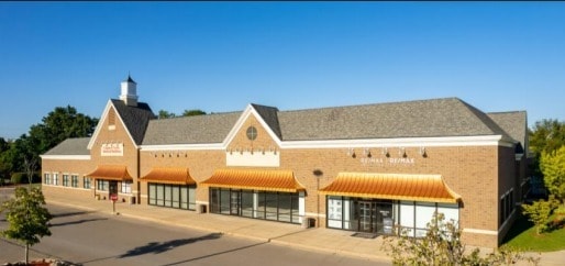
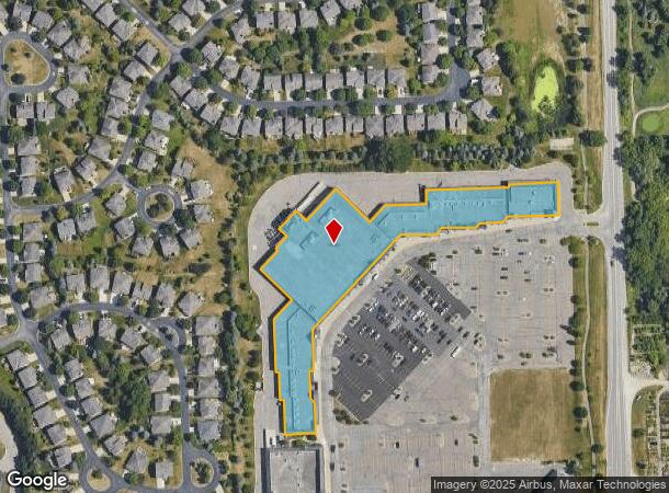
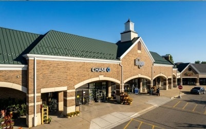
Property Record
4890 N Adams Rd, Rochester, MI 48306
NEARBY LISTINGS FOR SALE OR LEASE
Property Detail
4890 N Adams Rd
10-30-476-008
Oakland County Condominium
Regionalshoppingcenterormallwithanchorstore
T4N, R11E, SEC 30 OAKLAND COUNTY CONDOMINIUM PLAN NO 1670 COUNTRY CREEK COMMONS CONDO UNIT 1 L 34316 P 334 10-29-04 FR 005
X
Oakland
26125C0377F
Michigan
2024
3.09 AC
2025
St Clair & Lapeer Counties
190800
Detroit
133,546 SF
Detroit-Warren-Dearborn, MI
DEMOGRAPHICS near 4890 N Adams Rd
1 Mile
3 Mile
5 Mile
2024 Total Population
5,291
38,227
101,517
2029 Population
5,271
38,068
101,031
Pop Growth 2024-2029
(0.38%)
(0.42%)
(0.48%)
Average Age
41
41
40
2024 Total Households
1,951
13,709
39,419
HH Growth 2024-2029
(0.21%)
(0.28%)
(0.47%)
Median Household Inc
$161,749
$140,742
$104,359
Avg Household Size
2.70
2.70
2.40
2024 Avg HH Vehicles
2.00
2.00
2.00
Median Home Value
$476,895
$438,971
$380,882
Median Year Built
2000
1992
1982
Nearby Places
Map Layers
Map Styles
 Street
 Aerial
- Restaurants
- Banks
- Shops
- Fitness
- Groceries
PUBLIC TRANSPORTATION
AIRPORT
Detroit City
DRIVE
WALK
Distance
Detroit City
46 min
30.0 mi
Freight Ports
Port of Baltimore
DRIVE
WALK
Distance
Port of Baltimore
631 min
557.9 mi
SALE & LEASE HISTORY
LISTING DATE
SALE/LEASE

Sep 25, 2016
For Lease
Nov 29, 2018
For Lease
Nearby Properties
Address
Land Use
TOTAL SIZE
Lot Size
Zoning
Address
Land Use
TOTAL SIZE
Lot Size
Zoning
891,314 SF
60.90 AC
II
Address
Land Use
TOTAL SIZE
Lot Size
Zoning
179,510 SF
8.80 AC
Address
Land Use
TOTAL SIZE
Lot Size
Zoning
347,979 SF
58.38 AC
AI
Address
Land Use
TOTAL SIZE
Lot Size
Zoning
182,960 SF
28.25 AC
Address
Land Use
TOTAL SIZE
Lot Size
Zoning
329,335 SF
17.40 AC
Address
Land Use
TOTAL SIZE
Lot Size
Zoning
156,658 SF
13.61 AC
Address
Land Use
TOTAL SIZE
Lot Size
Zoning
158,978 SF
13.81 AC
Address
Land Use
TOTAL SIZE
Lot Size
Zoning
172,412 SF
9.68 AC
I1
Address
Land Use
TOTAL SIZE
Lot Size
Zoning
236,784 SF
21.50 AC
RM2
Address
Land Use
TOTAL SIZE
Lot Size
Zoning
175,822 SF
8.08 AC
II
Address
Land Use
TOTAL SIZE
Lot Size
Zoning
121,830 SF
9 AC
II
Address
Land Use
TOTAL SIZE
Lot Size
Zoning
116,140 SF
12.82 AC
II
Address
Land Use
TOTAL SIZE
Lot Size
Zoning
80,300 SF
Address
Land Use
TOTAL SIZE
Lot Size
Zoning
79,139 SF
6.55 AC
Address
Land Use
TOTAL SIZE
Lot Size
Zoning
74,557 SF
3.78 AC
IV
Address
Land Use
TOTAL SIZE
Lot Size
Zoning
119,816 SF
9.48 AC
Address
Land Use
TOTAL SIZE
Lot Size
Zoning
101,589 SF
7.44 AC
I1
Address
Land Use
TOTAL SIZE
Lot Size
Zoning
72,870 SF
5.95 AC
Address
Land Use
TOTAL SIZE
Lot Size
Zoning
125,100 SF
9.59 AC
II
Address
Land Use
TOTAL SIZE
Lot Size
Zoning
50,084 SF
15.02 AC
Address
Land Use
TOTAL SIZE
Lot Size
Zoning
89,400 SF
5.56 AC
IV
Address
Land Use
TOTAL SIZE
Lot Size
Zoning
112,634 SF
19.67 AC
BI
Address
Land Use
TOTAL SIZE
Lot Size
Zoning
61,479 SF
3.41 AC
II
Address
Land Use
TOTAL SIZE
Lot Size
Zoning
44,088 SF
6.32 AC
Address
Land Use
TOTAL SIZE
Lot Size
Zoning
Address
Land Use
TOTAL SIZE
Lot Size
Zoning
45,132 SF
10.45 AC
BI
Address
Land Use
TOTAL SIZE
Lot Size
Zoning
48,496 SF
31.34 AC
II
Address
Land Use
TOTAL SIZE
Lot Size
Zoning
167,529 SF
12.04 AC
I2
Address
Land Use
TOTAL SIZE
Lot Size
Zoning
58,748 SF
7.76 AC
TR
The World's #1 Commercial Real Estate Marketplace
Connect with us
© 2026 CoStar Group
The information above has been obtained from sources believed reliable. While we do not doubt its accuracy we have not verified it and make no guarantee, warranty or representation about it. It is your responsibility to independently confirm its accuracy and completeness. Any projections, opinions, assumptions, or estimates used are for example only and do not represent the current or future performance of the property. The value of this transaction to you depends on tax and other factors which should be evaluated by your tax, financial, and legal advisors. You and your advisors should conduct a careful, independent investigation of the property to determine to your satisfaction the suitability of the property for your needs.