Property Record
1163 N 48Th St, Springdale, AR 72762


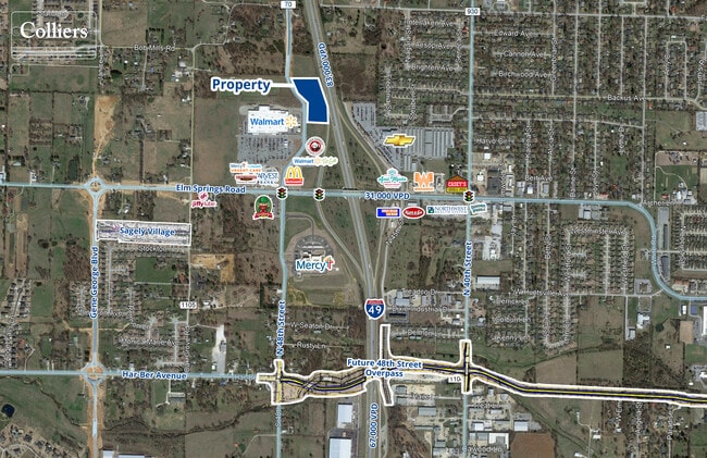
This Property Is For Sale
Property Detail
1163 N 48Th St
815-39272-000
WASHINGTON
Commercialnec
Arkansas
B and X Area of moderate flood hazard, usually the area between the limits of the 100-year and 500-year floods.
9
2025
1.32 AC
2025
Greater Springdale
010518
Fayetteville/Springdale/Rogers
8,184 SF
Fayetteville-Springdale-Rogers, AR
NEARBY LISTINGS FOR SALE OR LEASE
DEMOGRAPHICS near 1163 N 48Th St
1 mile
3 mile
5 mile
2025 Total Population
6,116
46,176
109,361
2030 Population
6,503
49,334
117,612
Pop Growth 2025-2030
+ 6.33%
+ 6.84%
+ 7.54%
Average Age
37
37
36
2025 Total Households
1,966
15,554
36,283
HH Growth 2025-2030
+ 6.51%
+ 7.08%
+ 7.75%
Median Household Inc
$76,350
$69,086
$72,586
Avg Household Size
3.00
2.80
2.90
2025 Avg HH Vehicles
2.00
2.00
2.00
Median Home Value
$274,549
$303,289
$312,641
Median Year Built
1994
1994
1996
Nearby Places
Map Layers
Map Styles
 Street
 Aerial
Transit
 Traffic
 Biking
Places
Listings with unknown addresses are not visible on the map
- Restaurants
- Banks
- Shops
- Fitness
- Groceries
PUBLIC TRANSPORTATION
AIRPORT
Northwest Arkansas Ntl
Drive
Walk
Distance
Northwest Arkansas Ntl
29 min
12.2 mi
Freight Ports
Tulsa Port of Inola
Drive
Walk
Distance
Tulsa Port of Inola
100 min
85.3 mi
Nearby Properties
Address
Land Use
TOTAL SIZE
Lot Size
Zoning
Address
Land Use
TOTAL SIZE
Lot Size
Zoning
58,764 SF
1.56 AC
Address
Land Use
TOTAL SIZE
Lot Size
Zoning
403,089 SF
1.93 AC
Address
Land Use
TOTAL SIZE
Lot Size
Zoning
54,448 SF
19.43 AC
Address
Land Use
TOTAL SIZE
Lot Size
Zoning
75,774 SF
16.49 AC
Address
Land Use
TOTAL SIZE
Lot Size
Zoning
181,734 SF
21.02 AC
Address
Land Use
TOTAL SIZE
Lot Size
Zoning
15,347 SF
6.27 AC
Address
Land Use
TOTAL SIZE
Lot Size
Zoning
437,349 SF
40.29 AC
Address
Land Use
TOTAL SIZE
Lot Size
Zoning
106,141 SF
2.82 AC
Address
Land Use
TOTAL SIZE
Lot Size
Zoning
153,718 SF
Address
Land Use
TOTAL SIZE
Lot Size
Zoning
81,000 SF
7.01 AC
Address
Land Use
TOTAL SIZE
Lot Size
Zoning
78,374 SF
8.79 AC
Address
Land Use
TOTAL SIZE
Lot Size
Zoning
112,817 SF
9.57 AC
Address
Land Use
TOTAL SIZE
Lot Size
Zoning
196,657 SF
18.82 AC
Address
Land Use
TOTAL SIZE
Lot Size
Zoning
117,690 SF
2.38 AC
Address
Land Use
TOTAL SIZE
Lot Size
Zoning
176,204 SF
7.57 AC
Address
Land Use
TOTAL SIZE
Lot Size
Zoning
193,140 SF
21.31 AC
Address
Land Use
TOTAL SIZE
Lot Size
Zoning
89,280 SF
12.22 AC
Address
Land Use
TOTAL SIZE
Lot Size
Zoning
134,342 SF
14.95 AC
Address
Land Use
TOTAL SIZE
Lot Size
Zoning
140,755 SF
14.15 AC
Address
Land Use
TOTAL SIZE
Lot Size
Zoning
16,698 SF
1.11 AC
Address
Land Use
TOTAL SIZE
Lot Size
Zoning
229,158 SF
21.23 AC
C2
Address
Land Use
TOTAL SIZE
Lot Size
Zoning
180,412 SF
13.14 AC
Address
Land Use
TOTAL SIZE
Lot Size
Zoning
167,040 SF
19.98 AC
Address
Land Use
TOTAL SIZE
Lot Size
Zoning
21,208 SF
1.89 AC
C2
Address
Land Use
TOTAL SIZE
Lot Size
Zoning
85,874 SF
2.76 AC
Address
Land Use
TOTAL SIZE
Lot Size
Zoning
16,760 SF
2.96 AC
Address
Land Use
TOTAL SIZE
Lot Size
Zoning
12,882 SF
12.33 AC
Address
Land Use
TOTAL SIZE
Lot Size
Zoning
31,150 SF
3.74 AC
C1
Address
Land Use
TOTAL SIZE
Lot Size
Zoning
80,475 SF
0.45 AC
C3
Address
Land Use
TOTAL SIZE
Lot Size
Zoning
73,711 SF
3.59 AC
The World's #1 Commercial Real Estate Marketplace
Connect with us
© 2026 CoStar Group
The information above has been obtained from sources believed reliable. While we do not doubt its accuracy we have not verified it and make no guarantee, warranty or representation about it. It is your responsibility to independently confirm its accuracy and completeness. Any projections, opinions, assumptions, or estimates used are for example only and do not represent the current or future performance of the property. The value of this transaction to you depends on tax and other factors which should be evaluated by your tax, financial, and legal advisors. You and your advisors should conduct a careful, independent investigation of the property to determine to your satisfaction the suitability of the property for your needs.