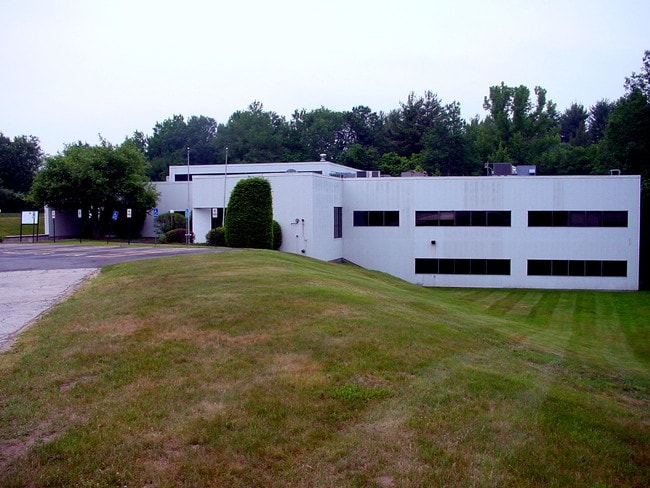
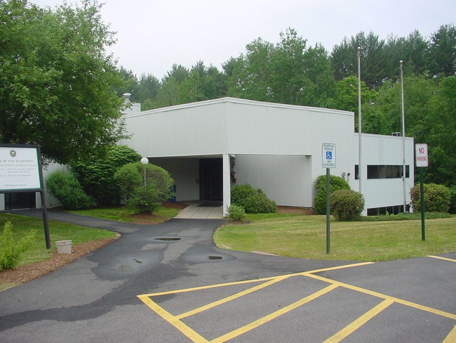
Property Record
49 Donovan St, Concord, NH 03301

Property Detail
49 Donovan St
CNCD-000001-000001-000015
Merrimack
Governmentalpublicusegeneral
New Hampshire
IS
15
A Areas with a 1% annual chance of flooding and a 26% chance of flooding over the life of a 30-year mortgage.
11.80 AC
2023
Concord/New Hampshire North Area
2025
Other Market Areas
032100
Concord, NH
29,403 SF
NEARBY LISTINGS FOR SALE OR LEASE
DEMOGRAPHICS near 49 Donovan St
1 mile
3 mile
5 mile
2025 Total Population
2,633
24,049
42,259
2030 Population
2,652
24,411
42,978
Pop Growth 2025-2030
+ 0.72%
+ 1.51%
+ 1.70%
Average Age
44
43
43
2025 Total Households
1,098
10,221
17,455
HH Growth 2025-2030
+ 0.82%
+ 1.65%
+ 1.78%
Median Household Inc
$114,623
$84,496
$92,662
Avg Household Size
2.30
2.20
2.30
2025 Avg HH Vehicles
2.00
2.00
2.00
Median Home Value
$393,109
$382,743
$388,159
Median Year Built
1948
1958
1970
Nearby Places
Map Layers
Map Styles
 Street
 Aerial
Transit
 Traffic
 Biking
Places
Listings with unknown addresses are not visible on the map
- Restaurants
- Banks
- Shops
- Fitness
- Groceries
PUBLIC TRANSPORTATION
AIRPORT
Manchester Boston Regional
Drive
Walk
Distance
Manchester Boston Regional
35 min
22.1 mi
SALE & LEASE HISTORY
LISTING DATE
SALE/LEASE

Sep 25, 2016
For Lease
Sep 24, 2016
For Sale
Aug 19, 2021
For Sale
Aug 19, 2021
For Lease
Nearby Properties
Address
Land Use
TOTAL SIZE
Lot Size
Zoning
Address
Land Use
TOTAL SIZE
Lot Size
Zoning
181,592 SF
5.53 AC
IS
Address
Land Use
TOTAL SIZE
Lot Size
Zoning
7.22 AC
IS
Address
Land Use
TOTAL SIZE
Lot Size
Zoning
230,929 SF
127 AC
IS
Address
Land Use
TOTAL SIZE
Lot Size
Zoning
283,455 SF
80 AC
LO-A
Address
Land Use
TOTAL SIZE
Lot Size
Zoning
161,715 SF
70 AC
CV
Address
Land Use
TOTAL SIZE
Lot Size
Zoning
128.74 AC
IS
Address
Land Use
TOTAL SIZE
Lot Size
Zoning
15.59 AC
GWP
Address
Land Use
TOTAL SIZE
Lot Size
Zoning
10.48 AC
IS
Address
Land Use
TOTAL SIZE
Lot Size
Zoning
11,576 SF
191 AC
C-1A
Address
Land Use
TOTAL SIZE
Lot Size
Zoning
1.92 AC
IS
Address
Land Use
TOTAL SIZE
Lot Size
Zoning
79,703 SF
2.16 AC
CVP
Address
Land Use
TOTAL SIZE
Lot Size
Zoning
88,452 SF
1.12 AC
IS
Address
Land Use
TOTAL SIZE
Lot Size
Zoning
110 AC
IN
Address
Land Use
TOTAL SIZE
Lot Size
Zoning
75,917 SF
0.30 AC
CBP
Address
Land Use
TOTAL SIZE
Lot Size
Zoning
5 AC
C
Address
Land Use
TOTAL SIZE
Lot Size
Zoning
1.34 AC
CVP
Address
Land Use
TOTAL SIZE
Lot Size
Zoning
25,725 SF
0.22 AC
IS
Address
Land Use
TOTAL SIZE
Lot Size
Zoning
89,791 SF
4.56 AC
IS
Address
Land Use
TOTAL SIZE
Lot Size
Zoning
15.22 AC
OCP
Address
Land Use
TOTAL SIZE
Lot Size
Zoning
81,493 SF
33 AC
CV
Address
Land Use
TOTAL SIZE
Lot Size
Zoning
146,511 SF
19.85 AC
RS
Address
Land Use
TOTAL SIZE
Lot Size
Zoning
11,574 SF
6.57 AC
CV
Address
Land Use
TOTAL SIZE
Lot Size
Zoning
41.95 AC
IN
Address
Land Use
TOTAL SIZE
Lot Size
Zoning
26.72 AC
IN
Address
Land Use
TOTAL SIZE
Lot Size
Zoning
13 AC
IS
Address
Land Use
TOTAL SIZE
Lot Size
Zoning
136,536 SF
17.69 AC
GWP
Address
Land Use
TOTAL SIZE
Lot Size
Zoning
109,643 SF
128.35 AC
IS
Address
Land Use
TOTAL SIZE
Lot Size
Zoning
52,750 SF
3.26 AC
OCP
Address
Land Use
TOTAL SIZE
Lot Size
Zoning
76,966 SF
11.15 AC
RS
Address
Land Use
TOTAL SIZE
Lot Size
Zoning
132,828 SF
1.31 AC
CBP
The World's #1 Commercial Real Estate Marketplace
Connect with us
© 2026 CoStar Group
The information above has been obtained from sources believed reliable. While we do not doubt its accuracy we have not verified it and make no guarantee, warranty or representation about it. It is your responsibility to independently confirm its accuracy and completeness. Any projections, opinions, assumptions, or estimates used are for example only and do not represent the current or future performance of the property. The value of this transaction to you depends on tax and other factors which should be evaluated by your tax, financial, and legal advisors. You and your advisors should conduct a careful, independent investigation of the property to determine to your satisfaction the suitability of the property for your needs.