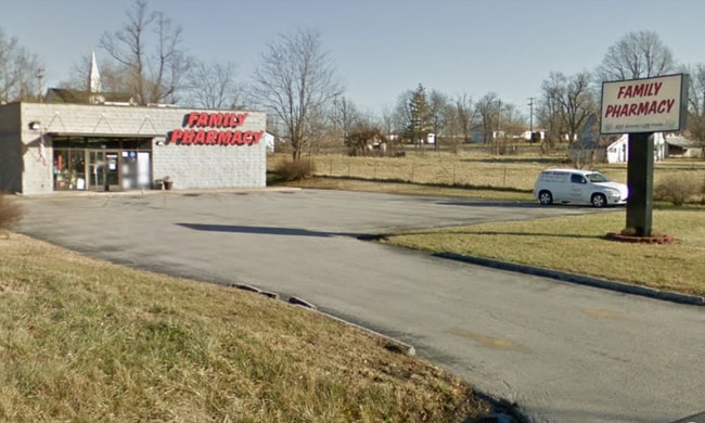
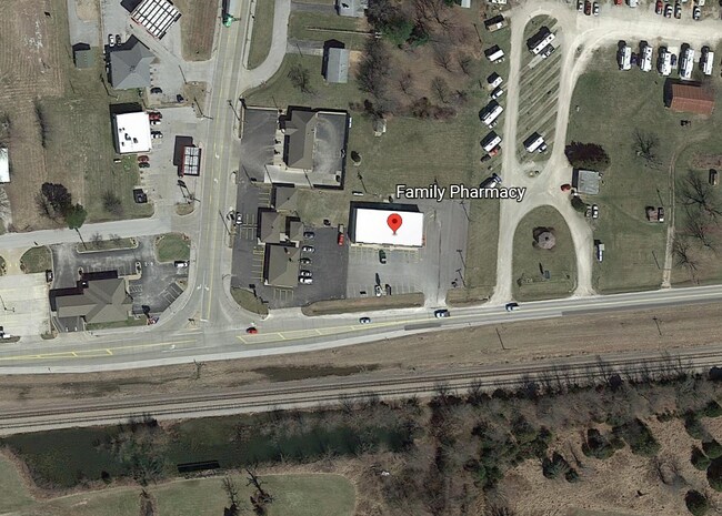
Property Record
49 E Old Mill Rd, Fair Grove, MO 65648

Property Detail
49 E Old Mill Rd
01-29-100-188
FAIR GROVE .42A M/L BEG 26 14/21 RDS (440 FT) E & 33.68 FT N SW COR NE1/4 NE1/4 29/31/20 N 182.79 FT W 100 FT S 181.69 FT E TO BEG
Storebuilding
Greene
INC
Missouri
B and X Area of moderate flood hazard, usually the area between the limits of the 100-year and 500-year floods.
0.42 AC
2025
Outlying Greene County
2025
Springfield
004602
Springfield, MO
2,000 SF
NEARBY LISTINGS FOR SALE OR LEASE
-
-
View all Fair Grove listings for sale on LoopNet.com
DEMOGRAPHICS near 49 E Old Mill Rd
1 mile
3 mile
5 mile
2025 Total Population
1,577
3,000
6,516
2030 Population
1,640
3,110
6,756
Pop Growth 2025-2030
+ 3.99%
+ 3.67%
+ 3.68%
Average Age
40
41
41
2025 Total Households
605
1,146
2,492
HH Growth 2025-2030
+ 4.13%
+ 3.93%
+ 3.85%
Median Household Inc
$81,189
$79,777
$78,937
Avg Household Size
2.60
2.60
2.60
2025 Avg HH Vehicles
2.00
2.00
3.00
Median Home Value
$248,366
$254,761
$271,170
Median Year Built
1990
1991
1991
Nearby Places
Map Layers
Map Styles
 Street
 Aerial
Layers
 Traffic
 Biking
Places
Listings with unknown addresses are not visible on the map
- Restaurants
- Banks
- Shops
- Fitness
- Groceries
PUBLIC TRANSPORTATION
AIRPORT
Springfield-Branson Ntl
Drive
Walk
Distance
Springfield-Branson Ntl
36 min
24.4 mi
SALE & LEASE HISTORY
LISTING DATE
SALE/LEASE

Nov 13, 2020
For Sale
Nearby Properties
Address
Land Use
TOTAL SIZE
Lot Size
Zoning
Address
Land Use
TOTAL SIZE
Lot Size
Zoning
1,635 SF
5.42 AC
INC
Address
Land Use
TOTAL SIZE
Lot Size
Zoning
3,822 SF
1.04 AC
INC
Address
Land Use
TOTAL SIZE
Lot Size
Zoning
14,880 SF
7.49 AC
INC
Address
Land Use
TOTAL SIZE
Lot Size
Zoning
20,592 SF
4 AC
INC
Address
Land Use
TOTAL SIZE
Lot Size
Zoning
4.03 AC
INC
Address
Land Use
TOTAL SIZE
Lot Size
Zoning
4,404 SF
2.03 AC
INC
Address
Land Use
TOTAL SIZE
Lot Size
Zoning
11,670 SF
2 AC
INC
Address
Land Use
TOTAL SIZE
Lot Size
Zoning
12,550 SF
2.22 AC
INC
Address
Land Use
TOTAL SIZE
Lot Size
Zoning
1.97 AC
INC
Address
Land Use
TOTAL SIZE
Lot Size
Zoning
3,209 SF
37.93 AC
A-1
Address
Land Use
TOTAL SIZE
Lot Size
Zoning
1.17 AC
INC.
Address
Land Use
TOTAL SIZE
Lot Size
Zoning
8,050 SF
0.90 AC
INC
Address
Land Use
TOTAL SIZE
Lot Size
Zoning
10,000 SF
3.11 AC
Address
Land Use
TOTAL SIZE
Lot Size
Zoning
6,476 SF
1.30 AC
INC
Address
Land Use
TOTAL SIZE
Lot Size
Zoning
3,770 SF
1.29 AC
INC
Address
Land Use
TOTAL SIZE
Lot Size
Zoning
1,709 SF
112.23 AC
A-1
Address
Land Use
TOTAL SIZE
Lot Size
Zoning
2,205 SF
2 AC
INC
Address
Land Use
TOTAL SIZE
Lot Size
Zoning
8,200 SF
0.80 AC
INC
Address
Land Use
TOTAL SIZE
Lot Size
Zoning
Address
Land Use
TOTAL SIZE
Lot Size
Zoning
7,386 SF
20.11 AC
A-1
Address
Land Use
TOTAL SIZE
Lot Size
Zoning
12,480 SF
3.90 AC
INC
Address
Land Use
TOTAL SIZE
Lot Size
Zoning
0.76 AC
INC
Address
Land Use
TOTAL SIZE
Lot Size
Zoning
7,108 SF
0.61 AC
INC
Address
Land Use
TOTAL SIZE
Lot Size
Zoning
6,280 SF
0.62 AC
INC
Address
Land Use
TOTAL SIZE
Lot Size
Zoning
2,422 SF
78.06 AC
A-1
Address
Land Use
TOTAL SIZE
Lot Size
Zoning
2,319 SF
10.03 AC
A-1
Address
Land Use
TOTAL SIZE
Lot Size
Zoning
6,320 SF
0.74 AC
INC
Address
Land Use
TOTAL SIZE
Lot Size
Zoning
2,715 SF
12 AC
A-1
Address
Land Use
TOTAL SIZE
Lot Size
Zoning
360 SF
4.30 AC
INC
The World's #1 Commercial Real Estate Marketplace
Connect with us
© 2026 CoStar Group
The information above has been obtained from sources believed reliable. While we do not doubt its accuracy we have not verified it and make no guarantee, warranty or representation about it. It is your responsibility to independently confirm its accuracy and completeness. Any projections, opinions, assumptions, or estimates used are for example only and do not represent the current or future performance of the property. The value of this transaction to you depends on tax and other factors which should be evaluated by your tax, financial, and legal advisors. You and your advisors should conduct a careful, independent investigation of the property to determine to your satisfaction the suitability of the property for your needs.