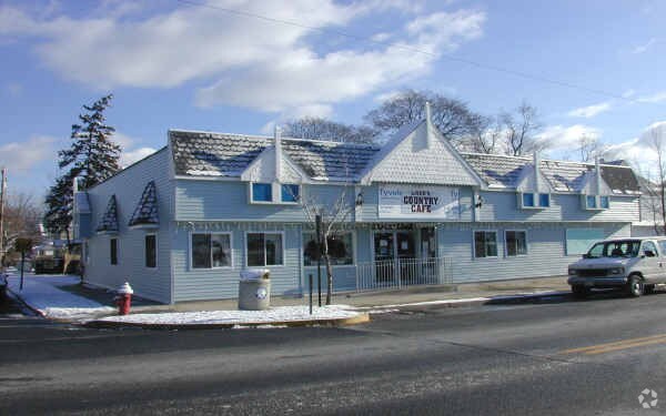
Property Record
49 E Railroad Ave, Jamesburg, NJ 08831

Property Detail
49 E Railroad Ave
Lakewood-New Brunswick, NJ
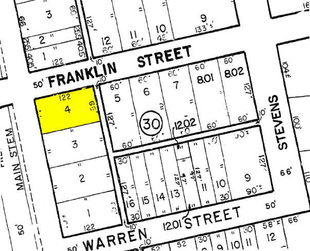
66X122
08-00030-0000-00004
Middlesex
Retailwithmorethanonenonretailuse
New Jersey
CBD
4
B and X Area of moderate flood hazard, usually the area between the limits of the 100-year and 500-year floods.
0.19 AC
2024
Brunswick
2025
Northern New Jersey
008300
NEARBY LISTINGS FOR SALE OR LEASE
DEMOGRAPHICS near 49 E Railroad Ave
1 mile
3 mile
5 mile
2025 Total Population
7,583
37,702
99,885
2030 Population
7,871
39,380
104,654
Pop Growth 2025-2030
+ 3.80%
+ 4.45%
+ 4.77%
Average Age
40
50
47
2025 Total Households
2,674
15,816
38,609
HH Growth 2025-2030
+ 3.74%
+ 4.27%
+ 4.73%
Median Household Inc
$118,771
$97,836
$119,468
Avg Household Size
2.80
2.30
2.50
2025 Avg HH Vehicles
2.00
2.00
2.00
Median Home Value
$434,091
$461,838
$538,895
Median Year Built
1973
1986
1987
Nearby Places
Map Layers
Map Styles
 Street
 Aerial
Layers
 Traffic
 Biking
Places
Listings with unknown addresses are not visible on the map
- Restaurants
- Banks
- Shops
- Fitness
- Groceries
PUBLIC TRANSPORTATION
AIRPORT
Trenton Mercer
Drive
Walk
Distance
Trenton Mercer
41 min
25.8 mi
Newark Liberty International
Drive
Walk
Distance
Newark Liberty International
50 min
37.7 mi
Freight Ports
New York Container Terminal
Drive
Walk
Distance
New York Container Terminal
43 min
32.8 mi
Nearby Properties
Address
Land Use
TOTAL SIZE
Lot Size
Zoning
Address
Land Use
TOTAL SIZE
Lot Size
Zoning
161,447 SF
67.62 AC
R30
Address
Land Use
TOTAL SIZE
Lot Size
Zoning
1,154,372 SF
167.04 AC
LI
Address
Land Use
TOTAL SIZE
Lot Size
Zoning
1,145,608 SF
73.19 AC
LI
Address
Land Use
TOTAL SIZE
Lot Size
Zoning
983,940 SF
62.53 AC
LI
Address
Land Use
TOTAL SIZE
Lot Size
Zoning
382,699 SF
29.60 AC
R30
Address
Land Use
TOTAL SIZE
Lot Size
Zoning
29,951 SF
55.65 AC
R20
Address
Land Use
TOTAL SIZE
Lot Size
Zoning
74.64 AC
LI
Address
Land Use
TOTAL SIZE
Lot Size
Zoning
51.28 AC
LI
Address
Land Use
TOTAL SIZE
Lot Size
Zoning
87.65 AC
LI-4
Address
Land Use
TOTAL SIZE
Lot Size
Zoning
528,314 SF
31.98 AC
LI
Address
Land Use
TOTAL SIZE
Lot Size
Zoning
14,552 SF
484.47 AC
R20
Address
Land Use
TOTAL SIZE
Lot Size
Zoning
29.74 AC
R30
Address
Land Use
TOTAL SIZE
Lot Size
Zoning
79.67 AC
I-3
Address
Land Use
TOTAL SIZE
Lot Size
Zoning
50.73 AC
I-3
Address
Land Use
TOTAL SIZE
Lot Size
Zoning
414,975 SF
37.45 AC
LI
Address
Land Use
TOTAL SIZE
Lot Size
Zoning
68,539 SF
14.40 AC
PRC
Address
Land Use
TOTAL SIZE
Lot Size
Zoning
5.10 AC
Address
Land Use
TOTAL SIZE
Lot Size
Zoning
18.93 AC
R30
Address
Land Use
TOTAL SIZE
Lot Size
Zoning
251,698 SF
0.01 AC
LI
Address
Land Use
TOTAL SIZE
Lot Size
Zoning
44.80 AC
LI-4
Address
Land Use
TOTAL SIZE
Lot Size
Zoning
49.12 AC
LI-4
Address
Land Use
TOTAL SIZE
Lot Size
Zoning
56 AC
LI-4
Address
Land Use
TOTAL SIZE
Lot Size
Zoning
168,226 SF
49.66 AC
R30
Address
Land Use
TOTAL SIZE
Lot Size
Zoning
324,567 SF
17.29 AC
LI
Address
Land Use
TOTAL SIZE
Lot Size
Zoning
299,532 SF
22.35 AC
LI
Address
Land Use
TOTAL SIZE
Lot Size
Zoning
5,660 SF
112.88 AC
HD
Address
Land Use
TOTAL SIZE
Lot Size
Zoning
43.90 AC
I-3
Address
Land Use
TOTAL SIZE
Lot Size
Zoning
413,092 SF
35.48 AC
LI-4
Address
Land Use
TOTAL SIZE
Lot Size
Zoning
227,175 SF
16.43 AC
LI
Address
Land Use
TOTAL SIZE
Lot Size
Zoning
34.73 AC
LI-4
The World's #1 Commercial Real Estate Marketplace
Connect with us
© 2026 CoStar Group
The information above has been obtained from sources believed reliable. While we do not doubt its accuracy we have not verified it and make no guarantee, warranty or representation about it. It is your responsibility to independently confirm its accuracy and completeness. Any projections, opinions, assumptions, or estimates used are for example only and do not represent the current or future performance of the property. The value of this transaction to you depends on tax and other factors which should be evaluated by your tax, financial, and legal advisors. You and your advisors should conduct a careful, independent investigation of the property to determine to your satisfaction the suitability of the property for your needs.