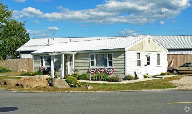
Property Record
49 Main St, New Castle, NH 03854
Save to a Folder
{{folder.Name}}
{{folder.ListingIds.length}} Properties
{{folder.ListingIds.length}} Property
Create a New Folder
Property Detail
49 Main St
Governmentalpublicusegeneral
ROCKINGHAM
MU MI
New Hampshire
B and X Area of moderate flood hazard, usually the area between the limits of the 100-year and 500-year floods.
0.23 AC
2025
Rockingham
2025
Boston
059000
Boston-Cambridge-Newton, MA-NH
3,588 SF
NCAS-000013-000008
NEARBY LISTINGS FOR SALE OR LEASE
DEMOGRAPHICS near 49 Main St
1 mile
3 mile
5 mile
2025 Total Population
2,351
9,265
21,191
2030 Population
2,432
9,459
21,441
Pop Growth 2025-2030
+ 3.45%
+ 2.09%
+ 1.18%
Average Age
42
43
43
2025 Total Households
922
3,478
7,922
HH Growth 2025-2030
+ 3.47%
+ 2.01%
+ 1.09%
Median Household Inc
$96,120
$106,602
$110,651
Avg Household Size
2.50
2.60
2.60
2025 Avg HH Vehicles
2.00
2.00
2.00
Median Home Value
$457,853
$466,586
$473,098
Median Year Built
1993
1992
1990
Nearby Places
Map Layers
Map Styles
 Street
 Aerial
Layers
 Traffic
 Biking
Places
Listings with unknown addresses are not visible on the map
- Restaurants
- Banks
- Shops
- Fitness
- Groceries
PUBLIC TRANSPORTATION
AIRPORT
Portsmouth International at Pease
Drive
Walk
Distance
Portsmouth International at Pease
19 min
6.6 mi
Freight Ports
Portland, ME
Drive
Walk
Distance
Portland, ME
69 min
54.0 mi
Nearby Properties
Address
Land Use
TOTAL SIZE
Lot Size
Zoning
Address
Land Use
TOTAL SIZE
Lot Size
Zoning
54.20 AC
M
Address
Land Use
TOTAL SIZE
Lot Size
Zoning
6.20 AC
G1
Address
Land Use
TOTAL SIZE
Lot Size
Zoning
138,881 SF
7.54 AC
PD PL
Address
Land Use
TOTAL SIZE
Lot Size
Zoning
152,028 SF
CD5
Address
Land Use
TOTAL SIZE
Lot Size
Zoning
144,226 SF
5.72 AC
M
Address
Land Use
TOTAL SIZE
Lot Size
Zoning
22.33 AC
MU-N
Address
Land Use
TOTAL SIZE
Lot Size
Zoning
Address
Land Use
TOTAL SIZE
Lot Size
Zoning
102,617 SF
1.27 AC
CD5
Address
Land Use
TOTAL SIZE
Lot Size
Zoning
136,711 SF
1.94 AC
CD5
Address
Land Use
TOTAL SIZE
Lot Size
Zoning
4.73 AC
CD4-W
Address
Land Use
TOTAL SIZE
Lot Size
Zoning
15,546 SF
137.50 AC
P+C
Address
Land Use
TOTAL SIZE
Lot Size
Zoning
86,293 SF
0.64 AC
CD5
Address
Land Use
TOTAL SIZE
Lot Size
Zoning
98,251 SF
1.49 AC
CD5
Address
Land Use
TOTAL SIZE
Lot Size
Zoning
15.20 AC
G1
Address
Land Use
TOTAL SIZE
Lot Size
Zoning
77,523 SF
CD5
Address
Land Use
TOTAL SIZE
Lot Size
Zoning
69,457 SF
0.98 AC
CD5
Address
Land Use
TOTAL SIZE
Lot Size
Zoning
58,070 SF
0.53 AC
CD4
Address
Land Use
TOTAL SIZE
Lot Size
Zoning
61,496 SF
17.59 AC
M
Address
Land Use
TOTAL SIZE
Lot Size
Zoning
57,711 SF
1.44 AC
CD4
Address
Land Use
TOTAL SIZE
Lot Size
Zoning
92,943 SF
9.55 AC
C-1
Address
Land Use
TOTAL SIZE
Lot Size
Zoning
117,164 SF
5.40 AC
C-3
Address
Land Use
TOTAL SIZE
Lot Size
Zoning
112,872 SF
9.43 AC
G1
Address
Land Use
TOTAL SIZE
Lot Size
Zoning
55,038 SF
0.61 AC
CD5
Address
Land Use
TOTAL SIZE
Lot Size
Zoning
8.04 AC
M
Address
Land Use
TOTAL SIZE
Lot Size
Zoning
64,354 SF
0.61 AC
CD5
Address
Land Use
TOTAL SIZE
Lot Size
Zoning
278,670 SF
1.86 AC
M
Address
Land Use
TOTAL SIZE
Lot Size
Zoning
12,905 SF
32.28 AC
SA S
Address
Land Use
TOTAL SIZE
Lot Size
Zoning
47,573 SF
1.96 AC
C-1
Address
Land Use
TOTAL SIZE
Lot Size
Zoning
57,456 SF
0.31 AC
CD5
Address
Land Use
TOTAL SIZE
Lot Size
Zoning
48,174 SF
CD5
The World's #1 Commercial Real Estate Marketplace
Connect with us
© 2026 CoStar Group
The information above has been obtained from sources believed reliable. While we do not doubt its accuracy we have not verified it and make no guarantee, warranty or representation about it. It is your responsibility to independently confirm its accuracy and completeness. Any projections, opinions, assumptions, or estimates used are for example only and do not represent the current or future performance of the property. The value of this transaction to you depends on tax and other factors which should be evaluated by your tax, financial, and legal advisors. You and your advisors should conduct a careful, independent investigation of the property to determine to your satisfaction the suitability of the property for your needs.