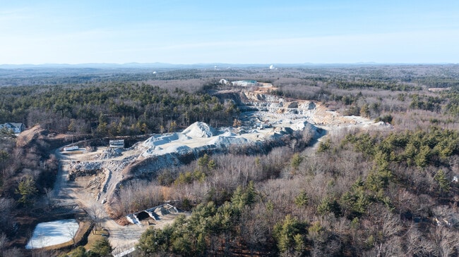
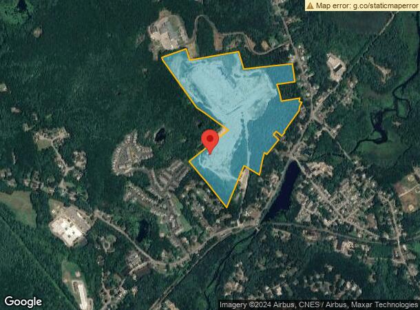
Property Record
49 N Main St, Westford, MA 01886
NEARBY LISTINGS FOR SALE OR LEASE
-
-
View all Westford listings for sale on LoopNet.com
Property Detail
49 N Main St
Industrialgeneral
Middlesex
X
Massachusetts
25017C0226F
63.60 AC
2025
Groton/Townsend
2025
Boston
318200
Boston-Cambridge-Newton, MA-NH
7,229 SF
WFOR-000030-000016
DEMOGRAPHICS near 49 N Main St
1 Mile
3 Mile
5 Mile
2024 Total Population
2,568
22,434
56,409
2029 Population
2,537
22,252
56,000
Pop Growth 2024-2029
(1.21%)
(0.81%)
(0.73%)
Average Age
40
41
42
2024 Total Households
908
7,865
20,470
HH Growth 2024-2029
(1.10%)
(0.90%)
(0.86%)
Median Household Inc
$159,697
$170,991
$154,041
Avg Household Size
2.80
2.80
2.70
2024 Avg HH Vehicles
2.00
2.00
2.00
Median Home Value
$629,381
$677,148
$633,414
Median Year Built
1982
1983
1981
Nearby Places
Map Layers
Map Styles
 Street
 Aerial
- Restaurants
- Banks
- Shops
- Fitness
- Groceries
PUBLIC TRANSPORTATION
COMMUTER RAIL
Ayer (Fitchburg/South Acton Line - Massachusetts Bay Transportation Authority Commuter Rail (Purple Line))
DRIVE
WALK
Distance
Ayer (Fitchburg/South Acton Line - Massachusetts Bay Transportation Authority Commuter Rail (Purple Line))
18 min
7.9 mi
Littleton/Route 495 (Fitchburg/South Acton Line - Massachusetts Bay Transportation Authority Commuter Rail (Purple Line))
DRIVE
WALK
Distance
Littleton/Route 495 (Fitchburg/South Acton Line - Massachusetts Bay Transportation Authority Commuter Rail (Purple Line))
17 min
8.3 mi
AIRPORT
Manchester Boston Regional
DRIVE
WALK
Distance
Manchester Boston Regional
46 min
29.4 mi
General Edward Lawrence Logan International
DRIVE
WALK
Distance
General Edward Lawrence Logan International
58 min
42.5 mi
Freight Ports
Port of Boston
DRIVE
WALK
Distance
Port of Boston
59 min
42.2 mi
SALE & LEASE HISTORY
LISTING DATE
SALE/LEASE

Mar 23, 2022
For Sale
Nearby Properties
Address
Land Use
TOTAL SIZE
Lot Size
Zoning
Address
Land Use
TOTAL SIZE
Lot Size
Zoning
279,042 SF
37.90 AC
RA
Address
Land Use
TOTAL SIZE
Lot Size
Zoning
171,661 SF
5.46 AC
IB
Address
Land Use
TOTAL SIZE
Lot Size
Zoning
137,558 SF
68.80 AC
RA
Address
Land Use
TOTAL SIZE
Lot Size
Zoning
109,556 SF
85.62 AC
RA
Address
Land Use
TOTAL SIZE
Lot Size
Zoning
125,642 SF
5.77 AC
IB
Address
Land Use
TOTAL SIZE
Lot Size
Zoning
119,130 SF
22.36 AC
RA
Address
Land Use
TOTAL SIZE
Lot Size
Zoning
85,450 SF
32.07 AC
RA
Address
Land Use
TOTAL SIZE
Lot Size
Zoning
63,420 SF
40.10 AC
RA
Address
Land Use
TOTAL SIZE
Lot Size
Zoning
58,766 SF
21.98 AC
RA
Address
Land Use
TOTAL SIZE
Lot Size
Zoning
44,417 SF
2.29 AC
RA
Address
Land Use
TOTAL SIZE
Lot Size
Zoning
41,635 SF
5.33 AC
RA
Address
Land Use
TOTAL SIZE
Lot Size
Zoning
60,552 SF
12.74 AC
IA
Address
Land Use
TOTAL SIZE
Lot Size
Zoning
42,332 SF
IA
Address
Land Use
TOTAL SIZE
Lot Size
Zoning
12,352 SF
4.81 AC
RA
Address
Land Use
TOTAL SIZE
Lot Size
Zoning
16 AC
IA
Address
Land Use
TOTAL SIZE
Lot Size
Zoning
23,668 SF
30 AC
RA
Address
Land Use
TOTAL SIZE
Lot Size
Zoning
26,426 SF
1.59 AC
RA
Address
Land Use
TOTAL SIZE
Lot Size
Zoning
4.27 AC
IA
Address
Land Use
TOTAL SIZE
Lot Size
Zoning
41,562 SF
25.57 AC
RA
Address
Land Use
TOTAL SIZE
Lot Size
Zoning
68,200 SF
6.43 AC
B1
Address
Land Use
TOTAL SIZE
Lot Size
Zoning
176,400 SF
28.50 AC
IB
Address
Land Use
TOTAL SIZE
Lot Size
Zoning
17,216 SF
1.47 AC
RB
Address
Land Use
TOTAL SIZE
Lot Size
Zoning
22,554 SF
5.20 AC
RA
Address
Land Use
TOTAL SIZE
Lot Size
Zoning
14,743 SF
1.09 AC
RA
Address
Land Use
TOTAL SIZE
Lot Size
Zoning
80 AC
R1
Address
Land Use
TOTAL SIZE
Lot Size
Zoning
12,347 SF
44 AC
RA
Address
Land Use
TOTAL SIZE
Lot Size
Zoning
14.31 AC
IA
Address
Land Use
TOTAL SIZE
Lot Size
Zoning
11,292 SF
0.50 AC
RA
Address
Land Use
TOTAL SIZE
Lot Size
Zoning
8,044 SF
4.43 AC
B1
Address
Land Use
TOTAL SIZE
Lot Size
Zoning
16,741 SF
1.75 AC
RA
The World's #1 Commercial Real Estate Marketplace
Connect with us
© 2025 CoStar Group
The information above has been obtained from sources believed reliable. While we do not doubt its accuracy we have not verified it and make no guarantee, warranty or representation about it. It is your responsibility to independently confirm its accuracy and completeness. Any projections, opinions, assumptions, or estimates used are for example only and do not represent the current or future performance of the property. The value of this transaction to you depends on tax and other factors which should be evaluated by your tax, financial, and legal advisors. You and your advisors should conduct a careful, independent investigation of the property to determine to your satisfaction the suitability of the property for your needs.