Property Record
49 Plain St, North Attleboro, MA 02760
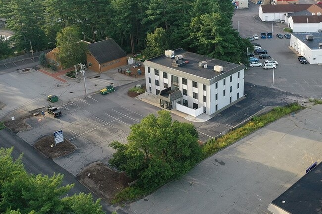


This Property Is For Sale
Current Lease Availabilities
Property Detail
49 Plain St
Officebuilding
Bristol
I60
Massachusetts
B and X Area of moderate flood hazard, usually the area between the limits of the 100-year and 500-year floods.
0.68 AC
2025
Attleboro/New Bedford
2025
Boston
630201
Providence-Warwick, RI-MA
9,200 SF
37 273 C
NEARBY LISTINGS FOR SALE OR LEASE
-
-
-
-
-
-
No Photo
-
-
View all North Attleboro listings for sale on LoopNet.com
DEMOGRAPHICS near 49 Plain St
1 mile
3 mile
5 mile
2025 Total Population
4,869
39,984
92,312
2030 Population
4,998
40,919
94,467
Pop Growth 2025-2030
+ 2.65%
+ 2.34%
+ 2.33%
Average Age
42
42
42
2025 Total Households
1,944
15,802
36,746
HH Growth 2025-2030
+ 2.73%
+ 2.39%
+ 2.41%
Median Household Inc
$105,565
$108,366
$106,695
Avg Household Size
2.50
2.50
2.50
2025 Avg HH Vehicles
2.00
2.00
2.00
Median Home Value
$499,510
$519,112
$559,582
Median Year Built
1981
1976
1974
Nearby Places
Map Layers
Map Styles
 Street
 Aerial
Layers
 Traffic
 Biking
Places
Listings with unknown addresses are not visible on the map
- Restaurants
- Banks
- Shops
- Fitness
- Groceries
PUBLIC TRANSPORTATION
COMMUTER RAIL
Drive
Walk
Distance
11 min
5.4 mi
Mansfield (Foxboro Line (Special Events Only) - Massachusetts Bay Transportation Authority Commuter Rail (Purple Line), Providence/Stoughton Line - Massachusetts Bay Transportation Authority Commuter Rail (Purple Line))
Drive
Walk
Distance
Mansfield (Foxboro Line (Special Events Only) - Massachusetts Bay Transportation Authority Commuter Rail (Purple Line), Providence/Stoughton Line - Massachusetts Bay Transportation Authority Commuter Rail (Purple Line))
13 min
5.6 mi
AIRPORT
Rhode Island Tf Green International
Drive
Walk
Distance
Rhode Island Tf Green International
42 min
25.3 mi
General Edward Lawrence Logan International
Drive
Walk
Distance
General Edward Lawrence Logan International
53 min
36.4 mi
Worcester Regional
Drive
Walk
Distance
Worcester Regional
64 min
44.2 mi
Nearby Properties
Address
Land Use
TOTAL SIZE
Lot Size
Zoning
Address
Land Use
TOTAL SIZE
Lot Size
Zoning
52,064 SF
87.51 AC
CI
Address
Land Use
TOTAL SIZE
Lot Size
Zoning
65.21 AC
Address
Land Use
TOTAL SIZE
Lot Size
Zoning
663,031 SF
44.44 AC
IB
Address
Land Use
TOTAL SIZE
Lot Size
Zoning
96,596 SF
17.01 AC
C-2 80
Address
Land Use
TOTAL SIZE
Lot Size
Zoning
98,369 SF
5.53 AC
IC30
Address
Land Use
TOTAL SIZE
Lot Size
Zoning
5,022 SF
22.90 AC
RB
Address
Land Use
TOTAL SIZE
Lot Size
Zoning
25.68 AC
Address
Land Use
TOTAL SIZE
Lot Size
Zoning
13.93 AC
CB
Address
Land Use
TOTAL SIZE
Lot Size
Zoning
28.55 AC
CC
Address
Land Use
TOTAL SIZE
Lot Size
Zoning
142,040 SF
18.16 AC
CI
Address
Land Use
TOTAL SIZE
Lot Size
Zoning
Address
Land Use
TOTAL SIZE
Lot Size
Zoning
22 AC
CI
Address
Land Use
TOTAL SIZE
Lot Size
Zoning
93,685 SF
8 AC
Address
Land Use
TOTAL SIZE
Lot Size
Zoning
105,166 SF
5.93 AC
Address
Land Use
TOTAL SIZE
Lot Size
Zoning
8.29 AC
R10
Address
Land Use
TOTAL SIZE
Lot Size
Zoning
79,322 SF
12.54 AC
R15
Address
Land Use
TOTAL SIZE
Lot Size
Zoning
186,200 SF
20.27 AC
Address
Land Use
TOTAL SIZE
Lot Size
Zoning
24.29 AC
Address
Land Use
TOTAL SIZE
Lot Size
Zoning
16.82 AC
C60
Address
Land Use
TOTAL SIZE
Lot Size
Zoning
9.52 AC
C7.5
Address
Land Use
TOTAL SIZE
Lot Size
Zoning
89,052 SF
17 AC
Address
Land Use
TOTAL SIZE
Lot Size
Zoning
72,331 SF
22.50 AC
Address
Land Use
TOTAL SIZE
Lot Size
Zoning
6.88 AC
CA
Address
Land Use
TOTAL SIZE
Lot Size
Zoning
83,651 SF
5.60 AC
Address
Land Use
TOTAL SIZE
Lot Size
Zoning
141,049 SF
22.77 AC
CI
Address
Land Use
TOTAL SIZE
Lot Size
Zoning
81,000 SF
4.76 AC
Address
Land Use
TOTAL SIZE
Lot Size
Zoning
12,958 SF
5.50 AC
Address
Land Use
TOTAL SIZE
Lot Size
Zoning
91,126 SF
9.71 AC
I60
Address
Land Use
TOTAL SIZE
Lot Size
Zoning
36,424 SF
1.18 AC
IC3
Address
Land Use
TOTAL SIZE
Lot Size
Zoning
77,304 SF
5.60 AC
The World's #1 Commercial Real Estate Marketplace
Connect with us
© 2026 CoStar Group
The information above has been obtained from sources believed reliable. While we do not doubt its accuracy we have not verified it and make no guarantee, warranty or representation about it. It is your responsibility to independently confirm its accuracy and completeness. Any projections, opinions, assumptions, or estimates used are for example only and do not represent the current or future performance of the property. The value of this transaction to you depends on tax and other factors which should be evaluated by your tax, financial, and legal advisors. You and your advisors should conduct a careful, independent investigation of the property to determine to your satisfaction the suitability of the property for your needs.