Property Record
49 S Main St, Centerville, OH 45458


Save to a Folder
{{folder.Name}}
{{folder.ListingIds.length}} Properties
{{folder.ListingIds.length}} Property
Create a New Folder
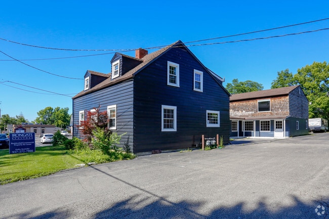
Property Detail
49 S Main St
Dayton, OH
5-6 PTS 1-5-22
O68-00105-0021
Montgomery
Storebuilding
Ohio
B and X Area of moderate flood hazard, usually the area between the limits of the 100-year and 500-year floods.
21
2025
0.05 AC
2025
South Dayton
040103
Cincinnati/Dayton
5,239 SF
NEARBY LISTINGS FOR SALE OR LEASE
DEMOGRAPHICS near 49 S Main St
1 mile
3 mile
5 mile
2025 Total Population
7,687
56,791
148,642
2030 Population
7,524
56,107
148,414
Pop Growth 2025-2030
(2.12%)
(1.20%)
(0.15%)
Average Age
41
44
42
2025 Total Households
3,443
24,755
63,319
HH Growth 2025-2030
(2.09%)
(1.18%)
(0.33%)
Median Household Inc
$66,989
$90,825
$89,549
Avg Household Size
2.20
2.20
2.30
2025 Avg HH Vehicles
2.00
2.00
2.00
Median Home Value
$270,443
$320,821
$305,544
Median Year Built
1974
1979
1979
Nearby Places
Map Layers
Map Styles
 Street
 Aerial
Layers
 Traffic
 Biking
Places
Listings with unknown addresses are not visible on the map
- Restaurants
- Banks
- Shops
- Fitness
- Groceries
PUBLIC TRANSPORTATION
AIRPORT
James M Cox Dayton International
Drive
Walk
Distance
James M Cox Dayton International
38 min
22.5 mi
Freight Ports
Port of Toledo
Drive
Walk
Distance
Port of Toledo
194 min
162.7 mi
Nearby Properties
Address
Land Use
TOTAL SIZE
Lot Size
Zoning
Address
Land Use
TOTAL SIZE
Lot Size
Zoning
508,366 SF
114.86 AC
Address
Land Use
TOTAL SIZE
Lot Size
Zoning
25,715 SF
23.28 AC
Address
Land Use
TOTAL SIZE
Lot Size
Zoning
42.40 AC
Address
Land Use
TOTAL SIZE
Lot Size
Zoning
462,864 SF
38.86 AC
Address
Land Use
TOTAL SIZE
Lot Size
Zoning
191,667 SF
35.98 AC
Address
Land Use
TOTAL SIZE
Lot Size
Zoning
490,354 SF
60 AC
Address
Land Use
TOTAL SIZE
Lot Size
Zoning
59,658 SF
74.94 AC
Address
Land Use
TOTAL SIZE
Lot Size
Zoning
5,461 SF
10.35 AC
Address
Land Use
TOTAL SIZE
Lot Size
Zoning
47,552 SF
47.55 AC
Address
Land Use
TOTAL SIZE
Lot Size
Zoning
203,122 SF
4.63 AC
Address
Land Use
TOTAL SIZE
Lot Size
Zoning
160,885 SF
22.44 AC
Address
Land Use
TOTAL SIZE
Lot Size
Zoning
318,347 SF
26.75 AC
Address
Land Use
TOTAL SIZE
Lot Size
Zoning
162,036 SF
9.81 AC
Address
Land Use
TOTAL SIZE
Lot Size
Zoning
122,173 SF
15.25 AC
Address
Land Use
TOTAL SIZE
Lot Size
Zoning
272,855 SF
29.01 AC
Address
Land Use
TOTAL SIZE
Lot Size
Zoning
81,787 SF
45.38 AC
Address
Land Use
TOTAL SIZE
Lot Size
Zoning
198,030 SF
22.32 AC
Address
Land Use
TOTAL SIZE
Lot Size
Zoning
89,683 SF
33.45 AC
Address
Land Use
TOTAL SIZE
Lot Size
Zoning
138,484 SF
23.04 AC
Address
Land Use
TOTAL SIZE
Lot Size
Zoning
24,928 SF
13.67 AC
Address
Land Use
TOTAL SIZE
Lot Size
Zoning
10.33 AC
Address
Land Use
TOTAL SIZE
Lot Size
Zoning
137,948 SF
4.60 AC
Address
Land Use
TOTAL SIZE
Lot Size
Zoning
279,833 SF
19.41 AC
Address
Land Use
TOTAL SIZE
Lot Size
Zoning
Address
Land Use
TOTAL SIZE
Lot Size
Zoning
10,912 SF
15.28 AC
Address
Land Use
TOTAL SIZE
Lot Size
Zoning
109,775 SF
1.25 AC
Address
Land Use
TOTAL SIZE
Lot Size
Zoning
148,369 SF
14.69 AC
Address
Land Use
TOTAL SIZE
Lot Size
Zoning
88,556 SF
23.94 AC
Address
Land Use
TOTAL SIZE
Lot Size
Zoning
44,736 SF
18.32 AC
Address
Land Use
TOTAL SIZE
Lot Size
Zoning
54,664 SF
19.37 AC
The World's #1 Commercial Real Estate Marketplace
Connect with us
© 2026 CoStar Group
The information above has been obtained from sources believed reliable. While we do not doubt its accuracy we have not verified it and make no guarantee, warranty or representation about it. It is your responsibility to independently confirm its accuracy and completeness. Any projections, opinions, assumptions, or estimates used are for example only and do not represent the current or future performance of the property. The value of this transaction to you depends on tax and other factors which should be evaluated by your tax, financial, and legal advisors. You and your advisors should conduct a careful, independent investigation of the property to determine to your satisfaction the suitability of the property for your needs.