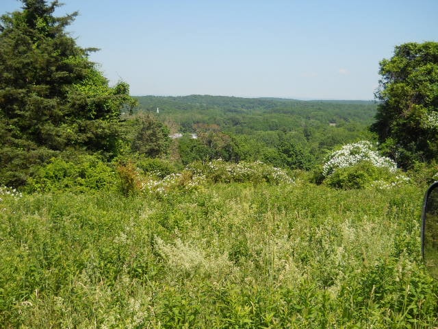
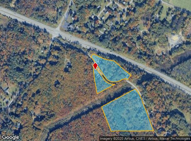
Property Record
49 Vedder Rd, Catskill, NY 12414
NEARBY LISTINGS FOR SALE OR LEASE
-
-
View all Catskill listings for sale on LoopNet.com
Property Detail
49 Vedder Rd
192689-138-001-0003-001-000-0000
L 874-P 110
Mobilehomepark
Greene
X
New York
36039C0268F
1.000
2025
18 AC
2024
Greene County
081101
Albany/Schenectady/Troy
1,620 SF
DEMOGRAPHICS near 49 Vedder Rd
1 Mile
3 Mile
5 Mile
2024 Total Population
555
4,945
13,078
2029 Population
559
5,029
13,298
Pop Growth 2024-2029
+ 0.72%
+ 1.70%
+ 1.68%
Average Age
45
46
45
2024 Total Households
253
2,109
5,827
HH Growth 2024-2029
+ 0.40%
+ 1.66%
+ 1.58%
Median Household Inc
$67,500
$62,799
$57,391
Avg Household Size
2.10
2.20
2.20
2024 Avg HH Vehicles
2.00
2.00
2.00
Median Home Value
$246,376
$202,818
$189,825
Median Year Built
1972
1970
1959
Nearby Places
Map Layers
Map Styles
 Street
 Aerial
- Restaurants
- Banks
- Shops
- Fitness
- Groceries
PUBLIC TRANSPORTATION
COMMUTER RAIL
Hudson Amtrak Station (Adirondack - Amtrak, Empire Service - Amtrak, Ethan Allen Express - Amtrak, Maple Leaf - Amtrak)
DRIVE
WALK
Distance
Hudson Amtrak Station (Adirondack - Amtrak, Empire Service - Amtrak, Ethan Allen Express - Amtrak, Maple Leaf - Amtrak)
16 min
9.1 mi
Hudson (Toronto - New York - VIA Rail)
DRIVE
WALK
Distance
Hudson (Toronto - New York - VIA Rail)
17 min
9.4 mi
Freight Ports
Albany, NY Port
DRIVE
WALK
Distance
Albany, NY Port
41 min
31.7 mi
Nearby Properties
Address
Land Use
TOTAL SIZE
Lot Size
Zoning
Address
Land Use
TOTAL SIZE
Lot Size
Zoning
120,765 SF
5.34 AC
05 - COMME
Address
Land Use
TOTAL SIZE
Lot Size
Zoning
15,750 SF
77.20 AC
02 - SINGL
Address
Land Use
TOTAL SIZE
Lot Size
Zoning
Address
Land Use
TOTAL SIZE
Lot Size
Zoning
103,792 SF
25.84 AC
02 - SINGL
Address
Land Use
TOTAL SIZE
Lot Size
Zoning
Address
Land Use
TOTAL SIZE
Lot Size
Zoning
22,954 SF
144.64 AC
02 - SINGL
Address
Land Use
TOTAL SIZE
Lot Size
Zoning
Address
Land Use
TOTAL SIZE
Lot Size
Zoning
Address
Land Use
TOTAL SIZE
Lot Size
Zoning
Address
Land Use
TOTAL SIZE
Lot Size
Zoning
770 SF
99.10 AC
08 - GOVER
Address
Land Use
TOTAL SIZE
Lot Size
Zoning
3,666 SF
7 AC
01 - NOT Z
Address
Land Use
TOTAL SIZE
Lot Size
Zoning
4,524 SF
156.66 AC
04 - FARM
Address
Land Use
TOTAL SIZE
Lot Size
Zoning
21,921 SF
95.10 AC
08 - GOVER
Address
Land Use
TOTAL SIZE
Lot Size
Zoning
23,103 SF
3.63 AC
05 - COMME
Address
Land Use
TOTAL SIZE
Lot Size
Zoning
1,106 SF
20.51 AC
07 - MIXED
Address
Land Use
TOTAL SIZE
Lot Size
Zoning
960 SF
57.60 AC
99
Address
Land Use
TOTAL SIZE
Lot Size
Zoning
Address
Land Use
TOTAL SIZE
Lot Size
Zoning
Address
Land Use
TOTAL SIZE
Lot Size
Zoning
4,098 SF
14.22 AC
02 - SINGL
Address
Land Use
TOTAL SIZE
Lot Size
Zoning
Address
Land Use
TOTAL SIZE
Lot Size
Zoning
4,627 SF
248.60 AC
04 - FARM
Address
Land Use
TOTAL SIZE
Lot Size
Zoning
Address
Land Use
TOTAL SIZE
Lot Size
Zoning
8,250 SF
7.96 AC
03 - MULTI
Address
Land Use
TOTAL SIZE
Lot Size
Zoning
2,978 SF
175.50 AC
RR
Address
Land Use
TOTAL SIZE
Lot Size
Zoning
Address
Land Use
TOTAL SIZE
Lot Size
Zoning
600 SF
4.30 AC
03 - MULTI
Address
Land Use
TOTAL SIZE
Lot Size
Zoning
6.91 AC
02 - SINGL
Address
Land Use
TOTAL SIZE
Lot Size
Zoning
114.23 AC
08 - GOVER
Address
Land Use
TOTAL SIZE
Lot Size
Zoning
4,156 SF
137.40 AC
08 - GOVER
Address
Land Use
TOTAL SIZE
Lot Size
Zoning
3,446 SF
119.60 AC
08 - GOVER
The World's #1 Commercial Real Estate Marketplace
Connect with us
© 2026 CoStar Group
The information above has been obtained from sources believed reliable. While we do not doubt its accuracy we have not verified it and make no guarantee, warranty or representation about it. It is your responsibility to independently confirm its accuracy and completeness. Any projections, opinions, assumptions, or estimates used are for example only and do not represent the current or future performance of the property. The value of this transaction to you depends on tax and other factors which should be evaluated by your tax, financial, and legal advisors. You and your advisors should conduct a careful, independent investigation of the property to determine to your satisfaction the suitability of the property for your needs.