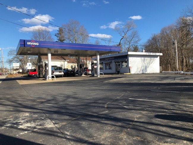
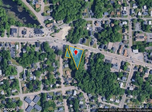
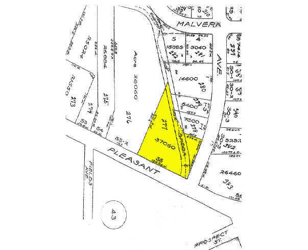
Property Record
490 Pleasant St, Brockton, MA 02301
NEARBY LISTINGS FOR SALE OR LEASE
Property Detail
490 Pleasant St
Servicestation
Plymouth
AE
Massachusetts
25023C0158J
0.85 AC
2025
Route 24
2025
Boston
510700
Boston-Cambridge-Newton, MA-NH
1,742 SF
BROC-000031-000277
DEMOGRAPHICS near 490 Pleasant St
1 Mile
3 Mile
5 Mile
2024 Total Population
21,707
104,163
173,772
2029 Population
21,313
102,920
172,150
Pop Growth 2024-2029
(1.82%)
(1.19%)
(0.93%)
Average Age
39
39
40
2024 Total Households
7,693
35,046
60,245
HH Growth 2024-2029
(1.81%)
(1.27%)
(0.98%)
Median Household Inc
$63,583
$73,598
$85,559
Avg Household Size
2.70
2.80
2.70
2024 Avg HH Vehicles
1.00
2.00
2.00
Median Home Value
$352,493
$366,188
$402,400
Median Year Built
1948
1958
1961
Nearby Places
Map Layers
Map Styles
 Street
 Aerial
- Restaurants
- Banks
- Shops
- Fitness
- Groceries
PUBLIC TRANSPORTATION
COMMUTER RAIL
Brockton (Middleborough/Lakeville Line - Massachusetts Bay Transportation Authority Commuter Rail (Purple Line))
DRIVE
WALK
Distance
Brockton (Middleborough/Lakeville Line - Massachusetts Bay Transportation Authority Commuter Rail (Purple Line))
2 min
1.2 mi
Montello (Middleborough/Lakeville Line - Massachusetts Bay Transportation Authority Commuter Rail (Purple Line))
DRIVE
WALK
Distance
Montello (Middleborough/Lakeville Line - Massachusetts Bay Transportation Authority Commuter Rail (Purple Line))
5 min
2.3 mi
AIRPORT
General Edward Lawrence Logan International
DRIVE
WALK
Distance
General Edward Lawrence Logan International
36 min
24.8 mi
Rhode Island Tf Green International
DRIVE
WALK
Distance
Rhode Island Tf Green International
67 min
43.5 mi
Freight Ports
Port of Boston
DRIVE
WALK
Distance
Port of Boston
34 min
22.6 mi
SALE & LEASE HISTORY
LISTING DATE
SALE/LEASE

Apr 05, 2018
For Sale
Nearby Properties
Address
Land Use
TOTAL SIZE
Lot Size
Zoning
Address
Land Use
TOTAL SIZE
Lot Size
Zoning
3,088 SF
1.42 AC
C3
Address
Land Use
TOTAL SIZE
Lot Size
Zoning
Address
Land Use
TOTAL SIZE
Lot Size
Zoning
95.27 AC
R1C
Address
Land Use
TOTAL SIZE
Lot Size
Zoning
1,352 SF
66.81 AC
R1B
Address
Land Use
TOTAL SIZE
Lot Size
Zoning
780 SF
10.81 AC
C5
Address
Land Use
TOTAL SIZE
Lot Size
Zoning
449,704 SF
3.56 AC
C2
Address
Land Use
TOTAL SIZE
Lot Size
Zoning
1,292 SF
36.06 AC
C5
Address
Land Use
TOTAL SIZE
Lot Size
Zoning
8.09 AC
R1C
Address
Land Use
TOTAL SIZE
Lot Size
Zoning
733 SF
16.41 AC
R1C
Address
Land Use
TOTAL SIZE
Lot Size
Zoning
27,951 SF
1.19 AC
R3
Address
Land Use
TOTAL SIZE
Lot Size
Zoning
920 SF
13.48 AC
R1C
Address
Land Use
TOTAL SIZE
Lot Size
Zoning
3,088 SF
1.38 AC
C3
Address
Land Use
TOTAL SIZE
Lot Size
Zoning
4,524 SF
12.31 AC
R1C
Address
Land Use
TOTAL SIZE
Lot Size
Zoning
3,438 SF
1.15 AC
C2
Address
Land Use
TOTAL SIZE
Lot Size
Zoning
379,908 SF
15.14 AC
Address
Land Use
TOTAL SIZE
Lot Size
Zoning
223,200 SF
5.26 AC
C2
Address
Land Use
TOTAL SIZE
Lot Size
Zoning
88,957 SF
0.57 AC
R2
Address
Land Use
TOTAL SIZE
Lot Size
Zoning
4,074 SF
3.82 AC
R3
Address
Land Use
TOTAL SIZE
Lot Size
Zoning
2,062 SF
5.01 AC
C2
Address
Land Use
TOTAL SIZE
Lot Size
Zoning
130,640 SF
10.27 AC
R1C
Address
Land Use
TOTAL SIZE
Lot Size
Zoning
2,600 SF
334.97 AC
R1C
Address
Land Use
TOTAL SIZE
Lot Size
Zoning
3,812 SF
0.64 AC
C3
Address
Land Use
TOTAL SIZE
Lot Size
Zoning
1,660 SF
31.95 AC
R1B
Address
Land Use
TOTAL SIZE
Lot Size
Zoning
299,062 SF
22.73 AC
R2
Address
Land Use
TOTAL SIZE
Lot Size
Zoning
1,172 SF
32.67 AC
R1C
Address
Land Use
TOTAL SIZE
Lot Size
Zoning
6,110 SF
14.03 AC
R1A
Address
Land Use
TOTAL SIZE
Lot Size
Zoning
254,946 SF
11.22 AC
R2
Address
Land Use
TOTAL SIZE
Lot Size
Zoning
3,255 SF
1 AC
C3
Address
Land Use
TOTAL SIZE
Lot Size
Zoning
253,912 SF
10.33 AC
R3
Address
Land Use
TOTAL SIZE
Lot Size
Zoning
2,884 SF
3.18 AC
R2
The World's #1 Commercial Real Estate Marketplace
Connect with us
© 2025 CoStar Group
The information above has been obtained from sources believed reliable. While we do not doubt its accuracy we have not verified it and make no guarantee, warranty or representation about it. It is your responsibility to independently confirm its accuracy and completeness. Any projections, opinions, assumptions, or estimates used are for example only and do not represent the current or future performance of the property. The value of this transaction to you depends on tax and other factors which should be evaluated by your tax, financial, and legal advisors. You and your advisors should conduct a careful, independent investigation of the property to determine to your satisfaction the suitability of the property for your needs.