Property Record
490 Boston Post Rd, North Windham, CT 06256
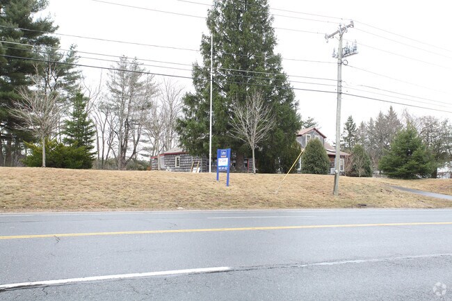

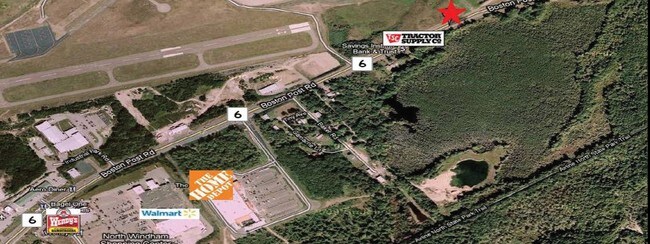
Property Detail
490 Boston Post Rd
WIND-000603-000225-000033A
Southeastern Ct
Commercialbuilding
Connecticut
C4
33a
2025
1.49 AC
2025
Windham County
800501
Hartford
1,595 SF
Willimantic, CT
NEARBY LISTINGS FOR SALE OR LEASE
DEMOGRAPHICS near 490 Boston Post Rd
1 mile
3 mile
5 mile
2025 Total Population
741
15,018
35,384
2030 Population
765
15,248
35,952
Pop Growth 2025-2030
+ 3.24%
+ 1.53%
+ 1.61%
Average Age
48
39
39
2025 Total Households
334
5,970
13,406
HH Growth 2025-2030
+ 3.29%
+ 1.59%
+ 1.68%
Median Household Inc
$73,420
$56,936
$62,234
Avg Household Size
2.10
2.30
2.40
2025 Avg HH Vehicles
2.00
2.00
2.00
Median Home Value
$156,666
$243,390
$254,017
Median Year Built
1989
1968
1965
Nearby Places
Map Layers
Map Styles
 Street
 Aerial
Layers
 Traffic
 Biking
Places
Listings with unknown addresses are not visible on the map
- Restaurants
- Banks
- Shops
- Fitness
- Groceries
PUBLIC TRANSPORTATION
AIRPORT
Bradley International
Drive
Walk
Distance
Bradley International
63 min
42.8 mi
Freight Ports
Port of Davisville, RI
Drive
Walk
Distance
Port of Davisville, RI
77 min
57.8 mi
Nearby Properties
Address
Land Use
TOTAL SIZE
Lot Size
Zoning
Address
Land Use
TOTAL SIZE
Lot Size
Zoning
47,712 SF
1 AC
I
Address
Land Use
TOTAL SIZE
Lot Size
Zoning
176,832 SF
I
Address
Land Use
TOTAL SIZE
Lot Size
Zoning
Address
Land Use
TOTAL SIZE
Lot Size
Zoning
79,493 SF
16.10 AC
RAR90
Address
Land Use
TOTAL SIZE
Lot Size
Zoning
14.50 AC
R20
Address
Land Use
TOTAL SIZE
Lot Size
Zoning
99,901 SF
1 AC
I
Address
Land Use
TOTAL SIZE
Lot Size
Zoning
61,837 SF
I
Address
Land Use
TOTAL SIZE
Lot Size
Zoning
102,324 SF
1 AC
I
Address
Land Use
TOTAL SIZE
Lot Size
Zoning
86,899 SF
18.27 AC
R3
Address
Land Use
TOTAL SIZE
Lot Size
Zoning
316,812 SF
39.88 AC
R4
Address
Land Use
TOTAL SIZE
Lot Size
Zoning
22.30 AC
RL
Address
Land Use
TOTAL SIZE
Lot Size
Zoning
126,220 SF
1 AC
I
Address
Land Use
TOTAL SIZE
Lot Size
Zoning
86,684 SF
1 AC
I
Address
Land Use
TOTAL SIZE
Lot Size
Zoning
275,230 SF
27.63 AC
PB1
Address
Land Use
TOTAL SIZE
Lot Size
Zoning
200 AC
R2 - 1
Address
Land Use
TOTAL SIZE
Lot Size
Zoning
6,340 SF
I
Address
Land Use
TOTAL SIZE
Lot Size
Zoning
231.54 AC
C2A
Address
Land Use
TOTAL SIZE
Lot Size
Zoning
37,325 SF
1 AC
I
Address
Land Use
TOTAL SIZE
Lot Size
Zoning
1,552 SF
10.06 AC
DMR
Address
Land Use
TOTAL SIZE
Lot Size
Zoning
90.58 AC
M1
Address
Land Use
TOTAL SIZE
Lot Size
Zoning
131 SF
M1 - 1
Address
Land Use
TOTAL SIZE
Lot Size
Zoning
70,200 SF
1 AC
I
Address
Land Use
TOTAL SIZE
Lot Size
Zoning
168,728 SF
24.40 AC
C4
Address
Land Use
TOTAL SIZE
Lot Size
Zoning
174 SF
R5
Address
Land Use
TOTAL SIZE
Lot Size
Zoning
35,941 SF
1 AC
I
Address
Land Use
TOTAL SIZE
Lot Size
Zoning
317,945 SF
2 AC
I
Address
Land Use
TOTAL SIZE
Lot Size
Zoning
12.04 AC
PB1
Address
Land Use
TOTAL SIZE
Lot Size
Zoning
45,068 SF
1 AC
I
Address
Land Use
TOTAL SIZE
Lot Size
Zoning
46,760 SF
1 AC
I
Address
Land Use
TOTAL SIZE
Lot Size
Zoning
46,760 SF
1 AC
I
The World's #1 Commercial Real Estate Marketplace
Connect with us
© 2026 CoStar Group
The information above has been obtained from sources believed reliable. While we do not doubt its accuracy we have not verified it and make no guarantee, warranty or representation about it. It is your responsibility to independently confirm its accuracy and completeness. Any projections, opinions, assumptions, or estimates used are for example only and do not represent the current or future performance of the property. The value of this transaction to you depends on tax and other factors which should be evaluated by your tax, financial, and legal advisors. You and your advisors should conduct a careful, independent investigation of the property to determine to your satisfaction the suitability of the property for your needs.