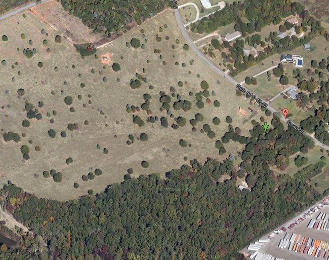
Property Record
490 Burns Rd, Greer, SC 29651
NEARBY LISTINGS FOR SALE OR LEASE
Property Detail
490 Burns Rd
Spartanburg, SC
Survey/T Walter Brashier
5-35-00-072.00
OPEN SPACE FRANKLIN POINTE PH 1 DB 85Q-597 PB 168-717 PB 169-833
Agriculturalland
Spartanburg
X
South Carolina
45045C0435E
80
2024
16.11 AC
2025
Rt 101 Corridor
002505
Greenville/Spartanburg
DEMOGRAPHICS near 490 Burns Rd
1 Mile
3 Mile
5 Mile
2024 Total Population
1,880
15,234
45,707
2029 Population
2,186
17,620
51,999
Pop Growth 2024-2029
+ 16.28%
+ 15.66%
+ 13.77%
Average Age
39
38
38
2024 Total Households
695
5,480
16,266
HH Growth 2024-2029
+ 16.55%
+ 15.93%
+ 14.10%
Median Household Inc
$77,514
$85,091
$90,575
Avg Household Size
2.70
2.80
2.80
2024 Avg HH Vehicles
3.00
2.00
2.00
Median Home Value
$245,337
$258,457
$273,700
Median Year Built
2005
2007
2005
Nearby Places
Map Layers
Map Styles
 Street
 Aerial
- Restaurants
- Banks
- Shops
- Fitness
- Groceries
PUBLIC TRANSPORTATION
AIRPORT
Greenville Spartanburg International
DRIVE
WALK
Distance
Greenville Spartanburg International
17 min
8.2 mi
Freight Ports
North Charleston Terminal
DRIVE
WALK
Distance
North Charleston Terminal
230 min
198.7 mi
Nearby Properties
Address
Land Use
TOTAL SIZE
Lot Size
Zoning
Address
Land Use
TOTAL SIZE
Lot Size
Zoning
380,932 SF
30.39 AC
Address
Land Use
TOTAL SIZE
Lot Size
Zoning
235,600 SF
14.48 AC
Address
Land Use
TOTAL SIZE
Lot Size
Zoning
214,064 SF
16.18 AC
Address
Land Use
TOTAL SIZE
Lot Size
Zoning
95.88 AC
Address
Land Use
TOTAL SIZE
Lot Size
Zoning
86,884 SF
5.31 AC
Address
Land Use
TOTAL SIZE
Lot Size
Zoning
2,417 SF
115.88 AC
Address
Land Use
TOTAL SIZE
Lot Size
Zoning
1,345 SF
115.58 AC
Address
Land Use
TOTAL SIZE
Lot Size
Zoning
177,675 SF
39.88 AC
Address
Land Use
TOTAL SIZE
Lot Size
Zoning
1,218 SF
34.73 AC
Address
Land Use
TOTAL SIZE
Lot Size
Zoning
215,006 SF
25.51 AC
Address
Land Use
TOTAL SIZE
Lot Size
Zoning
2,713 SF
61.50 AC
Address
Land Use
TOTAL SIZE
Lot Size
Zoning
8,543 SF
13.14 AC
Address
Land Use
TOTAL SIZE
Lot Size
Zoning
1,518 SF
78.61 AC
Address
Land Use
TOTAL SIZE
Lot Size
Zoning
72.04 AC
Address
Land Use
TOTAL SIZE
Lot Size
Zoning
56,769 SF
14.71 AC
Address
Land Use
TOTAL SIZE
Lot Size
Zoning
6,874 SF
1.79 AC
Address
Land Use
TOTAL SIZE
Lot Size
Zoning
13,628 SF
8.80 AC
Address
Land Use
TOTAL SIZE
Lot Size
Zoning
4,060 SF
0.60 AC
Address
Land Use
TOTAL SIZE
Lot Size
Zoning
4,192 SF
0.57 AC
Address
Land Use
TOTAL SIZE
Lot Size
Zoning
10.08 AC
Address
Land Use
TOTAL SIZE
Lot Size
Zoning
4,304 SF
0.65 AC
Address
Land Use
TOTAL SIZE
Lot Size
Zoning
2,672 SF
99.03 AC
Address
Land Use
TOTAL SIZE
Lot Size
Zoning
2,770 SF
0.72 AC
Address
Land Use
TOTAL SIZE
Lot Size
Zoning
168,750 SF
14.24 AC
Address
Land Use
TOTAL SIZE
Lot Size
Zoning
3,486 SF
0.19 AC
Address
Land Use
TOTAL SIZE
Lot Size
Zoning
4,592 SF
0.32 AC
Address
Land Use
TOTAL SIZE
Lot Size
Zoning
3,423 SF
0.17 AC
Address
Land Use
TOTAL SIZE
Lot Size
Zoning
3,718 SF
0.20 AC
Address
Land Use
TOTAL SIZE
Lot Size
Zoning
4,500 SF
0.54 AC
Address
Land Use
TOTAL SIZE
Lot Size
Zoning
1,050 SF
8.53 AC
The World's #1 Commercial Real Estate Marketplace
Connect with us
© 2026 CoStar Group
The information above has been obtained from sources believed reliable. While we do not doubt its accuracy we have not verified it and make no guarantee, warranty or representation about it. It is your responsibility to independently confirm its accuracy and completeness. Any projections, opinions, assumptions, or estimates used are for example only and do not represent the current or future performance of the property. The value of this transaction to you depends on tax and other factors which should be evaluated by your tax, financial, and legal advisors. You and your advisors should conduct a careful, independent investigation of the property to determine to your satisfaction the suitability of the property for your needs.