Property Record
490 F St, Lemoore, CA 93245
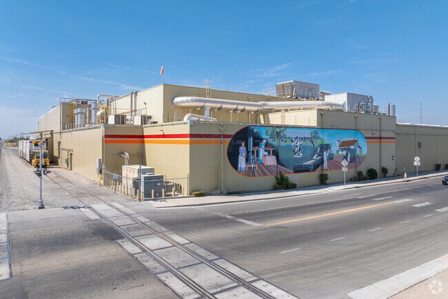

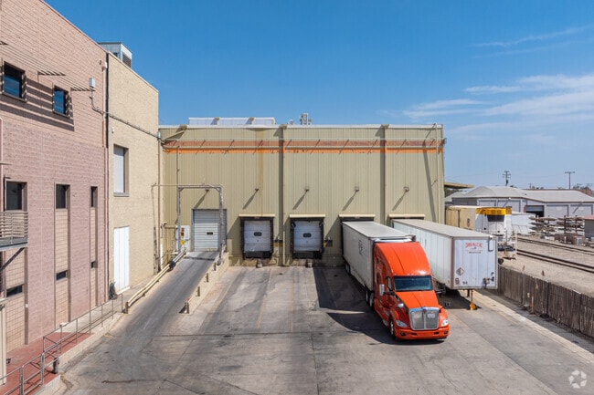
Property Detail
490 F St
020-016-021-000
490-546 F ST LEM
Foodprocessing
Kings
ML
California
B and X Area of moderate flood hazard, usually the area between the limits of the 100-year and 500-year floods.
4.25 AC
2024
Lemoore
2025
Fresno
000407
Hanford-Corcoran, CA
NEARBY LISTINGS FOR SALE OR LEASE
DEMOGRAPHICS near 490 F St
1 mile
3 mile
5 mile
2025 Total Population
16,032
29,336
36,572
2030 Population
16,047
29,465
36,859
Pop Growth 2025-2030
+ 0.09%
+ 0.44%
+ 0.78%
Average Age
35
35
35
2025 Total Households
5,528
9,975
12,082
HH Growth 2025-2030
+ 0.18%
+ 0.50%
+ 0.76%
Median Household Inc
$69,028
$78,954
$76,581
Avg Household Size
2.90
2.90
3.00
2025 Avg HH Vehicles
2.00
2.00
2.00
Median Home Value
$337,418
$354,800
$353,669
Median Year Built
1984
1987
1987
Nearby Places
Map Layers
Map Styles
 Street
 Aerial
Layers
 Traffic
 Biking
Places
Listings with unknown addresses are not visible on the map
- Restaurants
- Banks
- Shops
- Fitness
- Groceries
PUBLIC TRANSPORTATION
COMMUTER RAIL
Hanford (San Joaquins - Amtrak)
Drive
Walk
Distance
Hanford (San Joaquins - Amtrak)
12 min
8.6 mi
Freight Ports
Port of Stockton
Drive
Walk
Distance
Port of Stockton
186 min
167.8 mi
Nearby Properties
Address
Land Use
TOTAL SIZE
Lot Size
Zoning
Address
Land Use
TOTAL SIZE
Lot Size
Zoning
838,078 SF
60.81 AC
ML
Address
Land Use
TOTAL SIZE
Lot Size
Zoning
184,792 SF
11.05 AC
RMD
Address
Land Use
TOTAL SIZE
Lot Size
Zoning
10.45 AC
RHD
Address
Land Use
TOTAL SIZE
Lot Size
Zoning
5.43 AC
RMD
Address
Land Use
TOTAL SIZE
Lot Size
Zoning
31,104 SF
14.07 AC
ML
Address
Land Use
TOTAL SIZE
Lot Size
Zoning
46,362 SF
3.83 AC
NC
Address
Land Use
TOTAL SIZE
Lot Size
Zoning
110,190 SF
12.01 AC
RMD
Address
Land Use
TOTAL SIZE
Lot Size
Zoning
2.67 AC
CF
Address
Land Use
TOTAL SIZE
Lot Size
Zoning
4.70 AC
RHD
Address
Land Use
TOTAL SIZE
Lot Size
Zoning
7.84 AC
RMD
Address
Land Use
TOTAL SIZE
Lot Size
Zoning
Address
Land Use
TOTAL SIZE
Lot Size
Zoning
24.96 AC
ML
Address
Land Use
TOTAL SIZE
Lot Size
Zoning
37,500 SF
31.72 AC
ML
Address
Land Use
TOTAL SIZE
Lot Size
Zoning
3.13 AC
RM3
Address
Land Use
TOTAL SIZE
Lot Size
Zoning
139,680 SF
5.95 AC
RMD
Address
Land Use
TOTAL SIZE
Lot Size
Zoning
103,044 SF
8.82 AC
NC
Address
Land Use
TOTAL SIZE
Lot Size
Zoning
5.32 AC
RMD
Address
Land Use
TOTAL SIZE
Lot Size
Zoning
0.44 AC
DMX-1
Address
Land Use
TOTAL SIZE
Lot Size
Zoning
7.61 AC
NC
Address
Land Use
TOTAL SIZE
Lot Size
Zoning
19,535 SF
2.42 AC
NC
Address
Land Use
TOTAL SIZE
Lot Size
Zoning
2,380 SF
54.11 AC
RLD
Address
Land Use
TOTAL SIZE
Lot Size
Zoning
160 AC
AX
Address
Land Use
TOTAL SIZE
Lot Size
Zoning
164 AC
AL10
Address
Land Use
TOTAL SIZE
Lot Size
Zoning
4,001 SF
0.84 AC
RC
Address
Land Use
TOTAL SIZE
Lot Size
Zoning
2.20 AC
CH
Address
Land Use
TOTAL SIZE
Lot Size
Zoning
5,349 SF
1.94 AC
RC
Address
Land Use
TOTAL SIZE
Lot Size
Zoning
4,280 SF
1.49 AC
RC
Address
Land Use
TOTAL SIZE
Lot Size
Zoning
17,161 SF
2.01 AC
NC
Address
Land Use
TOTAL SIZE
Lot Size
Zoning
1,500 SF
3 AC
ML
The World's #1 Commercial Real Estate Marketplace
Connect with us
© 2026 CoStar Group
The information above has been obtained from sources believed reliable. While we do not doubt its accuracy we have not verified it and make no guarantee, warranty or representation about it. It is your responsibility to independently confirm its accuracy and completeness. Any projections, opinions, assumptions, or estimates used are for example only and do not represent the current or future performance of the property. The value of this transaction to you depends on tax and other factors which should be evaluated by your tax, financial, and legal advisors. You and your advisors should conduct a careful, independent investigation of the property to determine to your satisfaction the suitability of the property for your needs.