Property Record
490 Jacaranda Blvd, Venice, FL 34292


Property Detail
490 Jacaranda Blvd
0414-16-0001
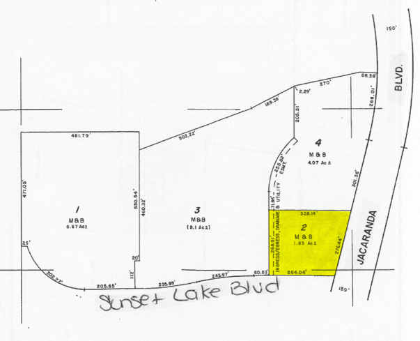
COM AT SW COR OF SEC 11-39-19 TH N 89-20-18 W ON THE S LINE OF SEC 10 A DISTANCE OF 261.21 FT FOR POB TH CONT ON SAID S LINE OF SEC 10 N 89-20-18 W 375.14 FT TO PT ON E R/W OF JACARANDA
Publicstorage
Sarasota
RMF2
Florida
B and X Area of moderate flood hazard, usually the area between the limits of the 100-year and 500-year floods.
52
2024
2.56 AC
2025
Sarasota
002716
Tampa/St Petersburg
92,967 SF
North Port-Bradenton-Sarasota, FL
NEARBY LISTINGS FOR SALE OR LEASE
DEMOGRAPHICS near 490 Jacaranda Blvd
1 mile
3 mile
5 mile
2025 Total Population
6,621
47,130
101,132
2030 Population
7,153
50,339
109,113
Pop Growth 2025-2030
+ 8.04%
+ 6.81%
+ 7.89%
Average Age
60
59
59
2025 Total Households
3,286
23,667
50,685
HH Growth 2025-2030
+ 8.09%
+ 6.87%
+ 8.00%
Median Household Inc
$79,065
$77,679
$77,917
Avg Household Size
1.90
1.90
1.90
2025 Avg HH Vehicles
2.00
2.00
2.00
Median Home Value
$451,355
$420,867
$442,339
Median Year Built
2002
1993
1992
Nearby Places
Map Layers
Map Styles
 Street
 Aerial
Layers
 Traffic
 Biking
Places
Listings with unknown addresses are not visible on the map
- Restaurants
- Banks
- Shops
- Fitness
- Groceries
PUBLIC TRANSPORTATION
AIRPORT
Sarasota/Bradenton International
Drive
Walk
Distance
Sarasota/Bradenton International
40 min
30.1 mi
Punta Gorda
Drive
Walk
Distance
Punta Gorda
41 min
33.8 mi
Freight Ports
Port Manatee
Drive
Walk
Distance
Port Manatee
53 min
42.6 mi
Nearby Properties
Address
Land Use
TOTAL SIZE
Lot Size
Zoning
Address
Land Use
TOTAL SIZE
Lot Size
Zoning
26,265 SF
210.50 AC
RMH
Address
Land Use
TOTAL SIZE
Lot Size
Zoning
333,296 SF
16.80 AC
RMF3
Address
Land Use
TOTAL SIZE
Lot Size
Zoning
432,671 SF
48.53 AC
RMF2
Address
Land Use
TOTAL SIZE
Lot Size
Zoning
421,272 SF
31.96 AC
PUD
Address
Land Use
TOTAL SIZE
Lot Size
Zoning
191,373 SF
23.12 AC
RMF2
Address
Land Use
TOTAL SIZE
Lot Size
Zoning
183,584 SF
14.54 AC
PUD
Address
Land Use
TOTAL SIZE
Lot Size
Zoning
123,659 SF
50.42 AC
RSF2
Address
Land Use
TOTAL SIZE
Lot Size
Zoning
5,208 SF
38.03 AC
CG
Address
Land Use
TOTAL SIZE
Lot Size
Zoning
81,883 SF
11.90 AC
CSC
Address
Land Use
TOTAL SIZE
Lot Size
Zoning
115,360 SF
14.60 AC
ILW
Address
Land Use
TOTAL SIZE
Lot Size
Zoning
146,990 SF
8.90 AC
CG
Address
Land Use
TOTAL SIZE
Lot Size
Zoning
63,549 SF
6.26 AC
OPI
Address
Land Use
TOTAL SIZE
Lot Size
Zoning
98,113 SF
12.05 AC
CSC
Address
Land Use
TOTAL SIZE
Lot Size
Zoning
111,306 SF
9.35 AC
CSC
Address
Land Use
TOTAL SIZE
Lot Size
Zoning
138,547 SF
18.63 AC
CSC
Address
Land Use
TOTAL SIZE
Lot Size
Zoning
78,975 SF
8.40 AC
RSF4
Address
Land Use
TOTAL SIZE
Lot Size
Zoning
66,899 SF
30.10 AC
GU
Address
Land Use
TOTAL SIZE
Lot Size
Zoning
121,747 SF
17.54 AC
OUE1
Address
Land Use
TOTAL SIZE
Lot Size
Zoning
101,219 SF
4.90 AC
OPI
Address
Land Use
TOTAL SIZE
Lot Size
Zoning
112,415 SF
8.77 AC
CSC
Address
Land Use
TOTAL SIZE
Lot Size
Zoning
76,247 SF
13.89 AC
CG
Address
Land Use
TOTAL SIZE
Lot Size
Zoning
74,937 SF
354.80 AC
RSF2
Address
Land Use
TOTAL SIZE
Lot Size
Zoning
125,001 SF
3.13 AC
CG
Address
Land Use
TOTAL SIZE
Lot Size
Zoning
8,040 SF
46.23 AC
RMH
Address
Land Use
TOTAL SIZE
Lot Size
Zoning
92,802 SF
4.78 AC
CN
Address
Land Use
TOTAL SIZE
Lot Size
Zoning
101,496 SF
19.08 AC
CG
Address
Land Use
TOTAL SIZE
Lot Size
Zoning
119,222 SF
12.47 AC
CG
Address
Land Use
TOTAL SIZE
Lot Size
Zoning
74,691 SF
2.99 AC
RSF2
Address
Land Use
TOTAL SIZE
Lot Size
Zoning
114,693 SF
15.16 AC
PUD
Address
Land Use
TOTAL SIZE
Lot Size
Zoning
30,560 SF
9.92 AC
G
The World's #1 Commercial Real Estate Marketplace
Connect with us
© 2026 CoStar Group
The information above has been obtained from sources believed reliable. While we do not doubt its accuracy we have not verified it and make no guarantee, warranty or representation about it. It is your responsibility to independently confirm its accuracy and completeness. Any projections, opinions, assumptions, or estimates used are for example only and do not represent the current or future performance of the property. The value of this transaction to you depends on tax and other factors which should be evaluated by your tax, financial, and legal advisors. You and your advisors should conduct a careful, independent investigation of the property to determine to your satisfaction the suitability of the property for your needs.