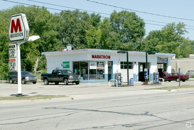
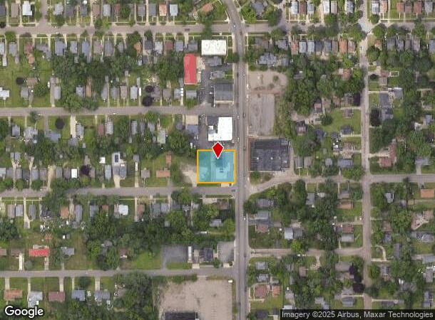
Property Record
490 Main St, Battle Creek, MI 49014
NEARBY LISTINGS FOR SALE OR LEASE
Property Detail
490 Main St
Battle Creek, MI
Sunrise Heights
10-700-001-00
EMMETT TWP/T2S R7W, SEC. 18: SUNRISE HEIGHTS; LOTS 1, 2, 3, 4 & E 1/2 LOT 5
Autorepair
Calhoun
X
Michigan
26025C0191C
1-5
2024
0.46 AC
2025
Battle Crk/W Calhoun Cnty
000600
West Michigan
1,740 SF
DEMOGRAPHICS near 490 Main St
1 Mile
3 Mile
5 Mile
2024 Total Population
5,742
47,560
74,315
2029 Population
5,694
47,182
73,599
Pop Growth 2024-2029
(0.84%)
(0.79%)
(0.96%)
Average Age
37
39
40
2024 Total Households
2,139
19,103
30,367
HH Growth 2024-2029
(0.94%)
(0.85%)
(0.98%)
Median Household Inc
$37,707
$48,269
$50,791
Avg Household Size
2.50
2.40
2.30
2024 Avg HH Vehicles
2.00
2.00
2.00
Median Home Value
$71,613
$103,881
$121,355
Median Year Built
1947
1953
1959
Nearby Places
Map Layers
Map Styles
 Street
 Aerial
- Restaurants
- Banks
- Shops
- Fitness
- Groceries
PUBLIC TRANSPORTATION
COMMUTER RAIL
DRIVE
WALK
Distance
3 min
1.6 mi
AIRPORT
Kalamazoo/Battle Creek International
DRIVE
WALK
Distance
Kalamazoo/Battle Creek International
34 min
25.1 mi
Nearby Properties
Address
Land Use
TOTAL SIZE
Lot Size
Zoning
Address
Land Use
TOTAL SIZE
Lot Size
Zoning
1,513,110 SF
108.07 AC
I2
Address
Land Use
TOTAL SIZE
Lot Size
Zoning
337,297 SF
18.85 AC
T4
Address
Land Use
TOTAL SIZE
Lot Size
Zoning
291,206 SF
18.98 AC
T4
Address
Land Use
TOTAL SIZE
Lot Size
Zoning
1,131,895 SF
26.46 AC
I1
Address
Land Use
TOTAL SIZE
Lot Size
Zoning
324,731 SF
69.91 AC
MF
Address
Land Use
TOTAL SIZE
Lot Size
Zoning
63,180 SF
3.55 AC
RC
Address
Land Use
TOTAL SIZE
Lot Size
Zoning
174,064 SF
T4
Address
Land Use
TOTAL SIZE
Lot Size
Zoning
52,764 SF
3.52 AC
AG
Address
Land Use
TOTAL SIZE
Lot Size
Zoning
79,074 SF
4.98 AC
RC
Address
Land Use
TOTAL SIZE
Lot Size
Zoning
221,522 SF
23.23 AC
RC
Address
Land Use
TOTAL SIZE
Lot Size
Zoning
158,786 SF
22.52 AC
HDR
Address
Land Use
TOTAL SIZE
Lot Size
Zoning
134,482 SF
17.15 AC
MFR
Address
Land Use
TOTAL SIZE
Lot Size
Zoning
134,355 SF
5.35 AC
MFR
Address
Land Use
TOTAL SIZE
Lot Size
Zoning
192,680 SF
21.66 AC
RC
Address
Land Use
TOTAL SIZE
Lot Size
Zoning
63,180 SF
12.12 AC
RC
Address
Land Use
TOTAL SIZE
Lot Size
Zoning
65,773 SF
2.42 AC
RC
Address
Land Use
TOTAL SIZE
Lot Size
Zoning
129,598 SF
0.62 AC
T5
Address
Land Use
TOTAL SIZE
Lot Size
Zoning
56,349 SF
7.54 AC
RC
Address
Land Use
TOTAL SIZE
Lot Size
Zoning
34,452 SF
1.12 AC
T4
Address
Land Use
TOTAL SIZE
Lot Size
Zoning
81,857 SF
9.29 AC
RC
Address
Land Use
TOTAL SIZE
Lot Size
Zoning
106,703 SF
9.69 AC
MFR
Address
Land Use
TOTAL SIZE
Lot Size
Zoning
126,060 SF
15.89 AC
MF
Address
Land Use
TOTAL SIZE
Lot Size
Zoning
366,290 SF
31.87 AC
B2
Address
Land Use
TOTAL SIZE
Lot Size
Zoning
44,034 SF
1.60 AC
RC
Address
Land Use
TOTAL SIZE
Lot Size
Zoning
49,412 SF
Address
Land Use
TOTAL SIZE
Lot Size
Zoning
188,388 SF
18.15 AC
T3
Address
Land Use
TOTAL SIZE
Lot Size
Zoning
85,654 SF
12.12 AC
RC
Address
Land Use
TOTAL SIZE
Lot Size
Zoning
52,109 SF
6.46 AC
MFR
Address
Land Use
TOTAL SIZE
Lot Size
Zoning
53,501 SF
7.34 AC
B1
Address
Land Use
TOTAL SIZE
Lot Size
Zoning
98,360 SF
0.31 AC
T5
The World's #1 Commercial Real Estate Marketplace
Connect with us
© 2025 CoStar Group
The information above has been obtained from sources believed reliable. While we do not doubt its accuracy we have not verified it and make no guarantee, warranty or representation about it. It is your responsibility to independently confirm its accuracy and completeness. Any projections, opinions, assumptions, or estimates used are for example only and do not represent the current or future performance of the property. The value of this transaction to you depends on tax and other factors which should be evaluated by your tax, financial, and legal advisors. You and your advisors should conduct a careful, independent investigation of the property to determine to your satisfaction the suitability of the property for your needs.