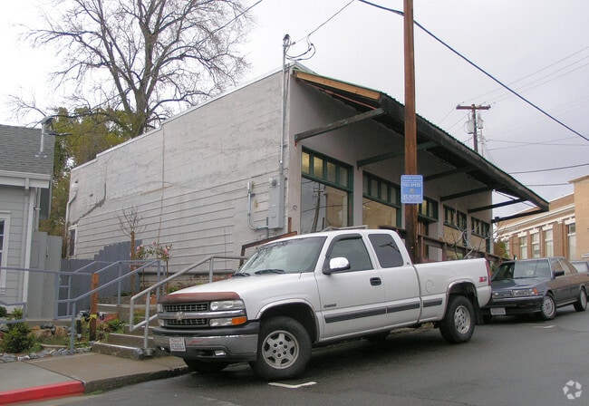
Property Record
490 Main St, Newcastle, CA 95658


NEARBY LISTINGS FOR SALE OR LEASE
-
-
View all Newcastle listings for sale on LoopNet.com
Property Detail
490 Main St
040-173-006
FR SEC 19 12 8
Storebuilding
Placer
X
California
06061C0960H
0.28 AC
2024
Roseville/Rocklin
2025
Sacramento
020501
Sacramento-Roseville-Folsom, CA
878 SF
DEMOGRAPHICS near 490 Main St
1 mile
3 mile
5 mile
2024 Total Population
1,214
11,286
40,241
2029 Population
1,292
12,070
43,081
Pop Growth 2024-2029
+ 6.43%
+ 6.95%
+ 7.06%
Average Age
46
46
45
2024 Total Households
474
4,361
16,038
HH Growth 2024-2029
+ 6.54%
+ 7.09%
+ 7.20%
Median Household Inc
$98,591
$116,683
$96,142
Avg Household Size
2.50
2.50
2.40
2024 Avg HH Vehicles
2.00
2.00
2.00
Median Home Value
$694,779
$743,959
$698,960
Median Year Built
1975
1978
1979
Nearby Places
Map Layers
Map Styles
 Street
 Aerial
Transit
 Traffic
 Biking
Places
Listings with unknown addresses are not visible on the map
- Restaurants
- Banks
- Shops
- Fitness
- Groceries
PUBLIC TRANSPORTATION
COMMUTER RAIL
Drive
Walk
Distance
7 min
4.8 mi
Drive
Walk
Distance
8 min
4.8 mi
AIRPORT
Sacramento International
Drive
Walk
Distance
Sacramento International
46 min
36.4 mi
Nearby Properties
Address
Land Use
TOTAL SIZE
Lot Size
Zoning
Address
Land Use
TOTAL SIZE
Lot Size
Zoning
3,424 SF
43.10 AC
Address
Land Use
TOTAL SIZE
Lot Size
Zoning
7,198 SF
5.33 AC
Address
Land Use
TOTAL SIZE
Lot Size
Zoning
4,915 SF
10.80 AC
RABX
Address
Land Use
TOTAL SIZE
Lot Size
Zoning
2,736 SF
0.55 AC
HSDC
Address
Land Use
TOTAL SIZE
Lot Size
Zoning
5,880 SF
2.30 AC
RAB100
Address
Land Use
TOTAL SIZE
Lot Size
Zoning
22,015 SF
1.90 AC
Address
Land Use
TOTAL SIZE
Lot Size
Zoning
6,932 SF
11.80 AC
RAB100
Address
Land Use
TOTAL SIZE
Lot Size
Zoning
7,666 SF
5 AC
F
Address
Land Use
TOTAL SIZE
Lot Size
Zoning
4,440 SF
2.40 AC
RAB100
Address
Land Use
TOTAL SIZE
Lot Size
Zoning
6,412 SF
4.90 AC
RABX
Address
Land Use
TOTAL SIZE
Lot Size
Zoning
7,944 SF
6.43 AC
RABX
Address
Land Use
TOTAL SIZE
Lot Size
Zoning
5,996 SF
3.40 AC
RAB100
Address
Land Use
TOTAL SIZE
Lot Size
Zoning
7,047 SF
7.20 AC
Address
Land Use
TOTAL SIZE
Lot Size
Zoning
7,104 SF
18.40 AC
RABX
Address
Land Use
TOTAL SIZE
Lot Size
Zoning
8,158 SF
4.60 AC
RAB100
Address
Land Use
TOTAL SIZE
Lot Size
Zoning
6,083 SF
1.30 AC
Address
Land Use
TOTAL SIZE
Lot Size
Zoning
14,240 SF
2.80 AC
INDC
Address
Land Use
TOTAL SIZE
Lot Size
Zoning
4,672 SF
10 AC
F
Address
Land Use
TOTAL SIZE
Lot Size
Zoning
29,500 SF
6.90 AC
INDC
Address
Land Use
TOTAL SIZE
Lot Size
Zoning
5,183 SF
4.60 AC
RABX
Address
Land Use
TOTAL SIZE
Lot Size
Zoning
6,990 SF
2.40 AC
RAB100
Address
Land Use
TOTAL SIZE
Lot Size
Zoning
5,002 SF
2.60 AC
RAB100
Address
Land Use
TOTAL SIZE
Lot Size
Zoning
5,315 SF
5.30 AC
RABX
Address
Land Use
TOTAL SIZE
Lot Size
Zoning
4,360 SF
2.30 AC
RAB100
Address
Land Use
TOTAL SIZE
Lot Size
Zoning
5,365 SF
4.80 AC
F
Address
Land Use
TOTAL SIZE
Lot Size
Zoning
3,261 SF
2.13 AC
RAB100
Address
Land Use
TOTAL SIZE
Lot Size
Zoning
1,618 SF
56.80 AC
Address
Land Use
TOTAL SIZE
Lot Size
Zoning
4,854 SF
5.90 AC
Address
Land Use
TOTAL SIZE
Lot Size
Zoning
4,067 SF
3.10 AC
RAB100
The World's #1 Commercial Real Estate Marketplace
Connect with us
© 2026 CoStar Group
The information above has been obtained from sources believed reliable. While we do not doubt its accuracy we have not verified it and make no guarantee, warranty or representation about it. It is your responsibility to independently confirm its accuracy and completeness. Any projections, opinions, assumptions, or estimates used are for example only and do not represent the current or future performance of the property. The value of this transaction to you depends on tax and other factors which should be evaluated by your tax, financial, and legal advisors. You and your advisors should conduct a careful, independent investigation of the property to determine to your satisfaction the suitability of the property for your needs.