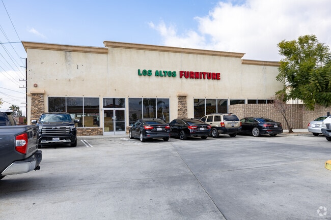
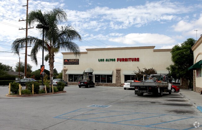
Property Record
490 N State St, San Jacinto, CA 92583

Save to a Folder
{{folder.Name}}
{{folder.ListingIds.length}} Properties
{{folder.ListingIds.length}} Property
Create a New Folder
Property Detail
490 N State St
Riverside-San Bernardino-Ontario, CA
3.98 ACRES NET IN PAR 3 PM 060/016 PM 12112
435-071-014
Riverside
Regionalshoppingcenterormallwithanchorstore
California
CM
3
2025
3.98 AC
2026
Beaumont/Hemet
051301
Inland Empire (California)
61,238 SF
NEARBY LISTINGS FOR SALE OR LEASE
DEMOGRAPHICS near 490 N State St
1 mile
3 mile
5 mile
2025 Total Population
14,919
104,409
174,357
2030 Population
15,372
107,760
179,538
Pop Growth 2025-2030
+ 3.04%
+ 3.21%
+ 2.97%
Average Age
34
37
38
2025 Total Households
4,162
33,060
56,546
HH Growth 2025-2030
+ 2.76%
+ 2.85%
+ 2.62%
Median Household Inc
$64,294
$60,373
$62,625
Avg Household Size
3.40
3.00
2.90
2025 Avg HH Vehicles
2.00
2.00
2.00
Median Home Value
$432,133
$380,115
$372,369
Median Year Built
1984
1986
1984
Nearby Places
Map Layers
Map Styles
 Street
 Aerial
Layers
 Traffic
 Biking
Places
Listings with unknown addresses are not visible on the map
- Restaurants
- Banks
- Shops
- Fitness
- Groceries
PUBLIC TRANSPORTATION
AIRPORT
Palm Springs International
Drive
Walk
Distance
Palm Springs International
51 min
42.8 mi
Freight Ports
Port of Long Beach
Drive
Walk
Distance
Port of Long Beach
112 min
85.5 mi
Nearby Properties
Address
Land Use
TOTAL SIZE
Lot Size
Zoning
Address
Land Use
TOTAL SIZE
Lot Size
Zoning
142,177 SF
111.75 AC
W2
Address
Land Use
TOTAL SIZE
Lot Size
Zoning
63,960 SF
8.57 AC
R3
Address
Land Use
TOTAL SIZE
Lot Size
Zoning
193,123 SF
19.92 AC
Address
Land Use
TOTAL SIZE
Lot Size
Zoning
40,880 SF
6 AC
R3
Address
Land Use
TOTAL SIZE
Lot Size
Zoning
66,482 SF
9.11 AC
A1
Address
Land Use
TOTAL SIZE
Lot Size
Zoning
58,941 SF
7.14 AC
Address
Land Use
TOTAL SIZE
Lot Size
Zoning
28,145 SF
4.67 AC
R3
Address
Land Use
TOTAL SIZE
Lot Size
Zoning
70,045 SF
4.23 AC
Address
Land Use
TOTAL SIZE
Lot Size
Zoning
72,308 SF
4.66 AC
M1
Address
Land Use
TOTAL SIZE
Lot Size
Zoning
58,941 SF
9.06 AC
M1
Address
Land Use
TOTAL SIZE
Lot Size
Zoning
1,396 SF
201.72 AC
A210
Address
Land Use
TOTAL SIZE
Lot Size
Zoning
107,874 SF
7.36 AC
Address
Land Use
TOTAL SIZE
Lot Size
Zoning
60,472 SF
2.22 AC
A15
Address
Land Use
TOTAL SIZE
Lot Size
Zoning
11,940 SF
1.12 AC
C1
Address
Land Use
TOTAL SIZE
Lot Size
Zoning
8,680 SF
2.11 AC
A210
Address
Land Use
TOTAL SIZE
Lot Size
Zoning
10,800 SF
6.56 AC
Address
Land Use
TOTAL SIZE
Lot Size
Zoning
158.35 AC
A210
Address
Land Use
TOTAL SIZE
Lot Size
Zoning
12,389 SF
7.31 AC
R3
Address
Land Use
TOTAL SIZE
Lot Size
Zoning
67,146 SF
13.97 AC
Address
Land Use
TOTAL SIZE
Lot Size
Zoning
97,878 SF
2.62 AC
C1
Address
Land Use
TOTAL SIZE
Lot Size
Zoning
89,392 SF
1.11 AC
Address
Land Use
TOTAL SIZE
Lot Size
Zoning
17,936 SF
1.48 AC
C2
Address
Land Use
TOTAL SIZE
Lot Size
Zoning
37,036 SF
5.65 AC
Address
Land Use
TOTAL SIZE
Lot Size
Zoning
38,026 SF
3.27 AC
R-1
Address
Land Use
TOTAL SIZE
Lot Size
Zoning
13,297 SF
1.40 AC
Address
Land Use
TOTAL SIZE
Lot Size
Zoning
134,250 SF
4.74 AC
M1
Address
Land Use
TOTAL SIZE
Lot Size
Zoning
38,159 SF
3.27 AC
Address
Land Use
TOTAL SIZE
Lot Size
Zoning
11,739 SF
4.33 AC
R3
Address
Land Use
TOTAL SIZE
Lot Size
Zoning
37,325 SF
4.03 AC
M1
The World's #1 Commercial Real Estate Marketplace
Connect with us
© 2026 CoStar Group
The information above has been obtained from sources believed reliable. While we do not doubt its accuracy we have not verified it and make no guarantee, warranty or representation about it. It is your responsibility to independently confirm its accuracy and completeness. Any projections, opinions, assumptions, or estimates used are for example only and do not represent the current or future performance of the property. The value of this transaction to you depends on tax and other factors which should be evaluated by your tax, financial, and legal advisors. You and your advisors should conduct a careful, independent investigation of the property to determine to your satisfaction the suitability of the property for your needs.