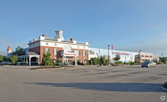
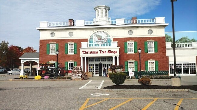
Property Record
490 Payne Rd, Scarborough, ME 04074
NEARBY LISTINGS FOR SALE OR LEASE
Property Detail
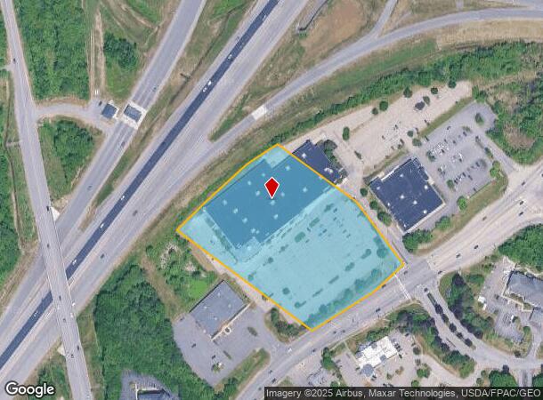
490 Payne Rd
SCAR-000037R-000000-000045
Cumberland
Regionalshoppingcenterormallwithanchorstore
Maine
X
45
23005C0688F
5.89 AC
2025
SW Cumberland County
2025
Portland/South Portland
017305
Portland-South Portland, ME
73,255 SF
DEMOGRAPHICS near 490 Payne Rd
1 Mile
3 Mile
5 Mile
2024 Total Population
600
21,008
96,101
2029 Population
650
21,835
99,236
Pop Growth 2024-2029
+ 8.33%
+ 3.94%
+ 3.26%
Average Age
51
43
41
2024 Total Households
307
9,019
43,533
HH Growth 2024-2029
+ 10.75%
+ 4.26%
+ 3.42%
Median Household Inc
$44,999
$71,899
$71,400
Avg Household Size
2.00
2.20
2.10
2024 Avg HH Vehicles
1.00
2.00
2.00
Median Home Value
$463,636
$334,756
$376,777
Median Year Built
2010
1983
1961
Nearby Places
Map Layers
Map Styles
 Street
 Aerial
- Restaurants
- Banks
- Shops
- Fitness
- Groceries
PUBLIC TRANSPORTATION
COMMUTER RAIL
DRIVE
WALK
Distance
9 min
4.8 mi
AIRPORT
Portland International Jetport
DRIVE
WALK
Distance
Portland International Jetport
9 min
3.0 mi
Freight Ports
Portland, ME
DRIVE
WALK
Distance
Portland, ME
11 min
6.0 mi
SALE & LEASE HISTORY
LISTING DATE
SALE/LEASE

Jul 13, 2023
For Lease
Nearby Properties
Address
Land Use
TOTAL SIZE
Lot Size
Zoning
Address
Land Use
TOTAL SIZE
Lot Size
Zoning
86.50 AC
Address
Land Use
TOTAL SIZE
Lot Size
Zoning
212.57 AC
Address
Land Use
TOTAL SIZE
Lot Size
Zoning
84,636 SF
31.70 AC
22
Address
Land Use
TOTAL SIZE
Lot Size
Zoning
408.26 AC
Address
Land Use
TOTAL SIZE
Lot Size
Zoning
45.50 AC
Address
Land Use
TOTAL SIZE
Lot Size
Zoning
20.35 AC
Address
Land Use
TOTAL SIZE
Lot Size
Zoning
53.27 AC
22
Address
Land Use
TOTAL SIZE
Lot Size
Zoning
28.33 AC
24
Address
Land Use
TOTAL SIZE
Lot Size
Zoning
401,800 SF
51.38 AC
31
Address
Land Use
TOTAL SIZE
Lot Size
Zoning
20.61 AC
TIFD
Address
Land Use
TOTAL SIZE
Lot Size
Zoning
7.51 AC
Z
Address
Land Use
TOTAL SIZE
Lot Size
Zoning
80,058 SF
14.69 AC
32
Address
Land Use
TOTAL SIZE
Lot Size
Zoning
176,100 SF
9.71 AC
Z
Address
Land Use
TOTAL SIZE
Lot Size
Zoning
34.33 AC
Z
Address
Land Use
TOTAL SIZE
Lot Size
Zoning
113,445 SF
12.70 AC
32
Address
Land Use
TOTAL SIZE
Lot Size
Zoning
115,965 SF
6.27 AC
Z
Address
Land Use
TOTAL SIZE
Lot Size
Zoning
20.33 AC
Z
Address
Land Use
TOTAL SIZE
Lot Size
Zoning
129,885 SF
28.33 AC
24
Address
Land Use
TOTAL SIZE
Lot Size
Zoning
17.95 AC
11
Address
Land Use
TOTAL SIZE
Lot Size
Zoning
217,672 SF
17.80 AC
Z
Address
Land Use
TOTAL SIZE
Lot Size
Zoning
8.62 AC
Z
Address
Land Use
TOTAL SIZE
Lot Size
Zoning
152,378 SF
29.34 AC
21
Address
Land Use
TOTAL SIZE
Lot Size
Zoning
78,053 SF
9.74 AC
32
Address
Land Use
TOTAL SIZE
Lot Size
Zoning
6.37 AC
BKH
Address
Land Use
TOTAL SIZE
Lot Size
Zoning
14.51 AC
Z
Address
Land Use
TOTAL SIZE
Lot Size
Zoning
151,484 SF
17.20 AC
Address
Land Use
TOTAL SIZE
Lot Size
Zoning
116,600 SF
12.37 AC
Z
Address
Land Use
TOTAL SIZE
Lot Size
Zoning
103,048 SF
2.78 AC
Address
Land Use
TOTAL SIZE
Lot Size
Zoning
144,304 SF
10.01 AC
Z
Address
Land Use
TOTAL SIZE
Lot Size
Zoning
188,361 SF
13.45 AC
MM
The World's #1 Commercial Real Estate Marketplace
Connect with us
© 2025 CoStar Group
The information above has been obtained from sources believed reliable. While we do not doubt its accuracy we have not verified it and make no guarantee, warranty or representation about it. It is your responsibility to independently confirm its accuracy and completeness. Any projections, opinions, assumptions, or estimates used are for example only and do not represent the current or future performance of the property. The value of this transaction to you depends on tax and other factors which should be evaluated by your tax, financial, and legal advisors. You and your advisors should conduct a careful, independent investigation of the property to determine to your satisfaction the suitability of the property for your needs.