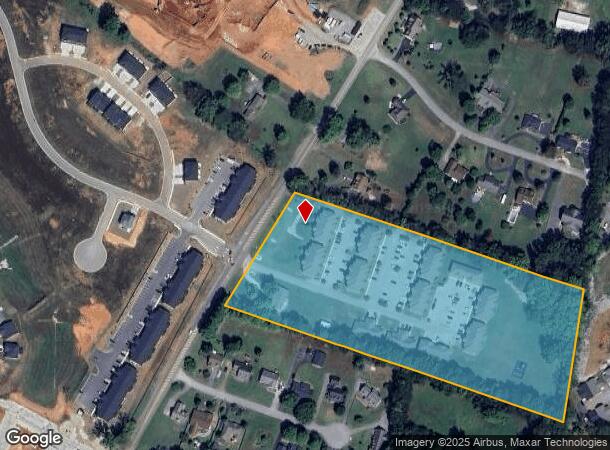
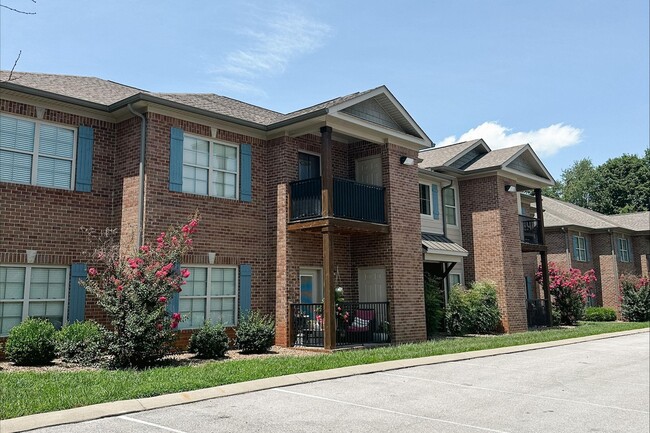
Property Record
490 Plano Rd, Bowling Green, KY 42104

NEARBY LISTINGS FOR SALE OR LEASE
-
-
View all Bowling Green listings for sale on LoopNet.com
Property Detail
490 Plano Rd
054A-03
Minor Sub
Multifamilydwelling
Warren
X
Kentucky
21227C0320E
3
2025
9.78 AC
2025
Bowling Green Area
010801
Other Market Areas
50,748 SF
Bowling Green, KY
DEMOGRAPHICS near 490 Plano Rd
1 Mile
3 Mile
5 Mile
2024 Total Population
3,115
30,061
60,607
2029 Population
3,521
33,337
66,989
Pop Growth 2024-2029
+ 13.03%
+ 10.90%
+ 10.53%
Average Age
38
38
38
2024 Total Households
1,226
11,843
24,541
HH Growth 2024-2029
+ 13.62%
+ 11.42%
+ 10.96%
Median Household Inc
$58,853
$66,714
$67,839
Avg Household Size
2.40
2.50
2.40
2024 Avg HH Vehicles
2.00
2.00
2.00
Median Home Value
$261,915
$262,516
$269,797
Median Year Built
2006
2000
1995
Nearby Places
Map Layers
Map Styles
 Street
 Aerial
- Restaurants
- Banks
- Shops
- Fitness
- Groceries
SALE & LEASE HISTORY
LISTING DATE
SALE/LEASE

Apr 11, 2023
For Sale
Nearby Properties
Address
Land Use
TOTAL SIZE
Lot Size
Zoning
Address
Land Use
TOTAL SIZE
Lot Size
Zoning
Address
Land Use
TOTAL SIZE
Lot Size
Zoning
26,586 SF
17.19 AC
Address
Land Use
TOTAL SIZE
Lot Size
Zoning
7,399 SF
57.89 AC
Address
Land Use
TOTAL SIZE
Lot Size
Zoning
173,947 SF
11.53 AC
Address
Land Use
TOTAL SIZE
Lot Size
Zoning
59,812 SF
21.30 AC
Address
Land Use
TOTAL SIZE
Lot Size
Zoning
86.84 AC
Address
Land Use
TOTAL SIZE
Lot Size
Zoning
261,196 SF
13.01 AC
Address
Land Use
TOTAL SIZE
Lot Size
Zoning
96,696 SF
9.69 AC
Address
Land Use
TOTAL SIZE
Lot Size
Zoning
208,264 SF
26.05 AC
Address
Land Use
TOTAL SIZE
Lot Size
Zoning
15,392 SF
8.50 AC
Address
Land Use
TOTAL SIZE
Lot Size
Zoning
62,904 SF
2.04 AC
Address
Land Use
TOTAL SIZE
Lot Size
Zoning
140,965 SF
16.37 AC
Address
Land Use
TOTAL SIZE
Lot Size
Zoning
2.48 AC
Address
Land Use
TOTAL SIZE
Lot Size
Zoning
73,660 SF
2 AC
Address
Land Use
TOTAL SIZE
Lot Size
Zoning
43,840 SF
13.76 AC
Address
Land Use
TOTAL SIZE
Lot Size
Zoning
Address
Land Use
TOTAL SIZE
Lot Size
Zoning
61,200 SF
6.72 AC
Address
Land Use
TOTAL SIZE
Lot Size
Zoning
4.43 AC
Address
Land Use
TOTAL SIZE
Lot Size
Zoning
56,595 SF
2.66 AC
Address
Land Use
TOTAL SIZE
Lot Size
Zoning
63,935 SF
2.35 AC
Address
Land Use
TOTAL SIZE
Lot Size
Zoning
97,310 SF
7.78 AC
Address
Land Use
TOTAL SIZE
Lot Size
Zoning
62,630 SF
4.54 AC
Address
Land Use
TOTAL SIZE
Lot Size
Zoning
35,099 SF
3.81 AC
Address
Land Use
TOTAL SIZE
Lot Size
Zoning
57,016 SF
1.80 AC
Address
Land Use
TOTAL SIZE
Lot Size
Zoning
42,961 SF
2.86 AC
Address
Land Use
TOTAL SIZE
Lot Size
Zoning
88,557 SF
9.23 AC
Address
Land Use
TOTAL SIZE
Lot Size
Zoning
40,347 SF
2.72 AC
Address
Land Use
TOTAL SIZE
Lot Size
Zoning
Address
Land Use
TOTAL SIZE
Lot Size
Zoning
35,207 SF
4.43 AC
The World's #1 Commercial Real Estate Marketplace
Connect with us
© 2026 CoStar Group
The information above has been obtained from sources believed reliable. While we do not doubt its accuracy we have not verified it and make no guarantee, warranty or representation about it. It is your responsibility to independently confirm its accuracy and completeness. Any projections, opinions, assumptions, or estimates used are for example only and do not represent the current or future performance of the property. The value of this transaction to you depends on tax and other factors which should be evaluated by your tax, financial, and legal advisors. You and your advisors should conduct a careful, independent investigation of the property to determine to your satisfaction the suitability of the property for your needs.