Property Record
490 Sand Sage Rd Nw, Los Lunas, NM 87031
NEARBY LISTINGS FOR SALE OR LEASE
-
-
View all Los Lunas listings for sale on LoopNet.com
Property Detail
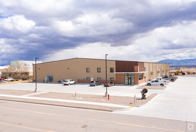
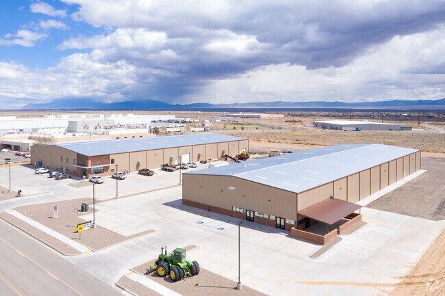
490 Sand Sage Rd Nw
Albuquerque, NM
Los Morros Business Park
1-007-039-270-376-000000
SUBD: LOS MORROS BUSINESS PARK TRACT: G-2 TRACT: G-2 S: 19 T: 7N R: 2E TRACTOR BREWING COMPANY 3.10 ACRES 1998 REV (COMMERCIAL)
Vacantlandnec
Valencia
X
New Mexico
35001C0725H
3.99 AC
2024
Los Lunas Corridor
2024
Albuquerque
970103
DEMOGRAPHICS near 490 Sand Sage Rd Nw
1 Mile
3 Mile
5 Mile
2024 Total Population
3,900
17,773
30,027
2029 Population
4,192
18,974
31,889
Pop Growth 2024-2029
+ 7.49%
+ 6.76%
+ 6.20%
Average Age
39
40
41
2024 Total Households
1,404
6,603
11,014
HH Growth 2024-2029
+ 7.83%
+ 7.00%
+ 6.46%
Median Household Inc
$62,045
$59,142
$59,024
Avg Household Size
2.70
2.60
2.60
2024 Avg HH Vehicles
2.00
2.00
2.00
Median Home Value
$201,181
$209,732
$224,923
Median Year Built
2005
1996
1991
Nearby Places
Map Layers
Map Styles
 Street
 Aerial
- Restaurants
- Banks
- Shops
- Fitness
- Groceries
PUBLIC TRANSPORTATION
COMMUTER RAIL
Los Lunas (NMRX - Rio Metro Regional Transit District, Rail Runner Express - Rio Metro Regional Transit District)
DRIVE
WALK
Distance
Los Lunas (NMRX - Rio Metro Regional Transit District, Rail Runner Express - Rio Metro Regional Transit District)
6 min
3.3 mi
AIRPORT
Albuquerque International Sunport
DRIVE
WALK
Distance
Albuquerque International Sunport
39 min
22.1 mi
Freight Ports
Port of San Diego
DRIVE
WALK
Distance
Port of San Diego
867 min
809.3 mi
Nearby Properties
Address
Land Use
TOTAL SIZE
Lot Size
Zoning
Address
Land Use
TOTAL SIZE
Lot Size
Zoning
108.83 AC
Address
Land Use
TOTAL SIZE
Lot Size
Zoning
168.84 AC
Address
Land Use
TOTAL SIZE
Lot Size
Zoning
Address
Land Use
TOTAL SIZE
Lot Size
Zoning
1,525.20 AC
Address
Land Use
TOTAL SIZE
Lot Size
Zoning
109.69 AC
Address
Land Use
TOTAL SIZE
Lot Size
Zoning
Address
Land Use
TOTAL SIZE
Lot Size
Zoning
14.79 AC
Address
Land Use
TOTAL SIZE
Lot Size
Zoning
66.69 AC
Address
Land Use
TOTAL SIZE
Lot Size
Zoning
4.90 AC
Address
Land Use
TOTAL SIZE
Lot Size
Zoning
14.68 AC
Address
Land Use
TOTAL SIZE
Lot Size
Zoning
Address
Land Use
TOTAL SIZE
Lot Size
Zoning
106,160 SF
13.72 AC
Address
Land Use
TOTAL SIZE
Lot Size
Zoning
187,077 SF
18.96 AC
Address
Land Use
TOTAL SIZE
Lot Size
Zoning
381,767 SF
19.99 AC
Address
Land Use
TOTAL SIZE
Lot Size
Zoning
Address
Land Use
TOTAL SIZE
Lot Size
Zoning
25.46 AC
Address
Land Use
TOTAL SIZE
Lot Size
Zoning
94,883 SF
12.09 AC
Address
Land Use
TOTAL SIZE
Lot Size
Zoning
121,362 SF
12.42 AC
Address
Land Use
TOTAL SIZE
Lot Size
Zoning
1.31 AC
Address
Land Use
TOTAL SIZE
Lot Size
Zoning
Address
Land Use
TOTAL SIZE
Lot Size
Zoning
100,000 SF
6 AC
Address
Land Use
TOTAL SIZE
Lot Size
Zoning
12.72 AC
Address
Land Use
TOTAL SIZE
Lot Size
Zoning
Address
Land Use
TOTAL SIZE
Lot Size
Zoning
76,324 SF
3.85 AC
Address
Land Use
TOTAL SIZE
Lot Size
Zoning
48,250 SF
5.70 AC
Address
Land Use
TOTAL SIZE
Lot Size
Zoning
Address
Land Use
TOTAL SIZE
Lot Size
Zoning
2.82 AC
Address
Land Use
TOTAL SIZE
Lot Size
Zoning
5,493 SF
3.85 AC
Address
Land Use
TOTAL SIZE
Lot Size
Zoning
23,000 SF
2.88 AC
The World's #1 Commercial Real Estate Marketplace
Connect with us
© 2025 CoStar Group
The information above has been obtained from sources believed reliable. While we do not doubt its accuracy we have not verified it and make no guarantee, warranty or representation about it. It is your responsibility to independently confirm its accuracy and completeness. Any projections, opinions, assumptions, or estimates used are for example only and do not represent the current or future performance of the property. The value of this transaction to you depends on tax and other factors which should be evaluated by your tax, financial, and legal advisors. You and your advisors should conduct a careful, independent investigation of the property to determine to your satisfaction the suitability of the property for your needs.