Property Record
490 Westfield Rd, Charlottesville, VA 22901
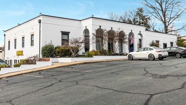


This Property Is For Sale
Current Lease Availabilities
Property Detail
490 Westfield Rd
061W0-01-0C-00400
WESTFIELD 2 NATURE CONSERVANCY
Officebuilding
Albemarle
C1 COMMERC
Virginia
B and X Area of moderate flood hazard, usually the area between the limits of the 100-year and 500-year floods.
0.99 AC
2025
Charlottesville
2026
Other Market Areas
010702
Charlottesville, VA
11,783 SF
NEARBY LISTINGS FOR SALE OR LEASE
DEMOGRAPHICS near 490 Westfield Rd
1 mile
3 mile
5 mile
2025 Total Population
13,200
54,933
104,566
2030 Population
13,481
55,597
105,922
Pop Growth 2025-2030
+ 2.13%
+ 1.21%
+ 1.30%
Average Age
41
38
38
2025 Total Households
5,726
22,492
42,295
HH Growth 2025-2030
+ 2.53%
+ 1.36%
+ 1.39%
Median Household Inc
$62,014
$75,212
$83,357
Avg Household Size
2.10
2.20
2.20
2025 Avg HH Vehicles
2.00
2.00
2.00
Median Home Value
$337,916
$498,462
$480,481
Median Year Built
1981
1981
1985
Nearby Places
Map Layers
Map Styles
 Street
 Aerial
Layers
 Traffic
 Biking
Places
Listings with unknown addresses are not visible on the map
- Restaurants
- Banks
- Shops
- Fitness
- Groceries
PUBLIC TRANSPORTATION
COMMUTER RAIL
Drive
Walk
Distance
9 min
3.8 mi
AIRPORT
Charlottesville-Albemarle
Drive
Walk
Distance
Charlottesville-Albemarle
14 min
6.6 mi
Nearby Properties
Address
Land Use
TOTAL SIZE
Lot Size
Zoning
Address
Land Use
TOTAL SIZE
Lot Size
Zoning
872,960 SF
20.90 AC
CM
Address
Land Use
TOTAL SIZE
Lot Size
Zoning
13,125 SF
100.40 AC
R1 RESIDEN
Address
Land Use
TOTAL SIZE
Lot Size
Zoning
45 AC
RURAL AREA
Address
Land Use
TOTAL SIZE
Lot Size
Zoning
61,177 SF
30.40 AC
R1 RESIDEN
Address
Land Use
TOTAL SIZE
Lot Size
Zoning
167,708 SF
1.05 AC
CM
Address
Land Use
TOTAL SIZE
Lot Size
Zoning
34.70 AC
RURAL AREA
Address
Land Use
TOTAL SIZE
Lot Size
Zoning
15 AC
RURAL AREA
Address
Land Use
TOTAL SIZE
Lot Size
Zoning
497,658 SF
39.83 AC
NX-10
Address
Land Use
TOTAL SIZE
Lot Size
Zoning
3,465 SF
145.17 AC
CV
Address
Land Use
TOTAL SIZE
Lot Size
Zoning
254,749 SF
80.72 AC
CM
Address
Land Use
TOTAL SIZE
Lot Size
Zoning
45,873 SF
30 AC
RURAL AREA
Address
Land Use
TOTAL SIZE
Lot Size
Zoning
62,900 SF
4.71 AC
NX-10
Address
Land Use
TOTAL SIZE
Lot Size
Zoning
3,803 SF
266.70 AC
CV
Address
Land Use
TOTAL SIZE
Lot Size
Zoning
10,270 SF
3.59 AC
RX-5
Address
Land Use
TOTAL SIZE
Lot Size
Zoning
43,616 SF
2.24 AC
CX-8
Address
Land Use
TOTAL SIZE
Lot Size
Zoning
578,208 SF
2.06 AC
CX-8
Address
Land Use
TOTAL SIZE
Lot Size
Zoning
12,180 SF
26.20 AC
RURAL AREA
Address
Land Use
TOTAL SIZE
Lot Size
Zoning
46,770 SF
216.69 AC
RURAL AREA
Address
Land Use
TOTAL SIZE
Lot Size
Zoning
12,876 SF
32.37 AC
NEIGHBORHO
Address
Land Use
TOTAL SIZE
Lot Size
Zoning
393,960 SF
16.14 AC
NMD
Address
Land Use
TOTAL SIZE
Lot Size
Zoning
30,896 SF
0.97 AC
DX
Address
Land Use
TOTAL SIZE
Lot Size
Zoning
240,936 SF
1.26 AC
NX-10
Address
Land Use
TOTAL SIZE
Lot Size
Zoning
78,332 SF
33.82 AC
CM
Address
Land Use
TOTAL SIZE
Lot Size
Zoning
195,000 SF
11.16 AC
R1 RESIDEN
Address
Land Use
TOTAL SIZE
Lot Size
Zoning
Address
Land Use
TOTAL SIZE
Lot Size
Zoning
218,660 SF
1.27 AC
CX-8
Address
Land Use
TOTAL SIZE
Lot Size
Zoning
224,196 SF
58.91 AC
PLANNED RE
Address
Land Use
TOTAL SIZE
Lot Size
Zoning
5,157 SF
25.55 AC
R4 RESIDEN
Address
Land Use
TOTAL SIZE
Lot Size
Zoning
1.38 AC
CX-3
Address
Land Use
TOTAL SIZE
Lot Size
Zoning
222,253 SF
0.73 AC
NX-10
The World's #1 Commercial Real Estate Marketplace
Connect with us
© 2026 CoStar Group
The information above has been obtained from sources believed reliable. While we do not doubt its accuracy we have not verified it and make no guarantee, warranty or representation about it. It is your responsibility to independently confirm its accuracy and completeness. Any projections, opinions, assumptions, or estimates used are for example only and do not represent the current or future performance of the property. The value of this transaction to you depends on tax and other factors which should be evaluated by your tax, financial, and legal advisors. You and your advisors should conduct a careful, independent investigation of the property to determine to your satisfaction the suitability of the property for your needs.