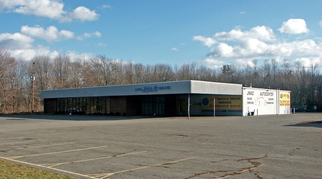
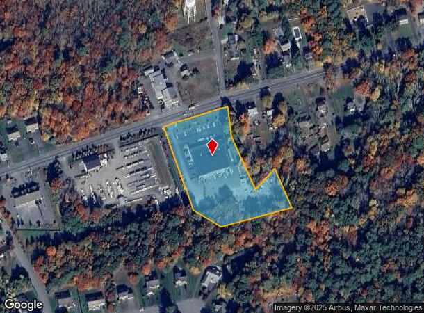
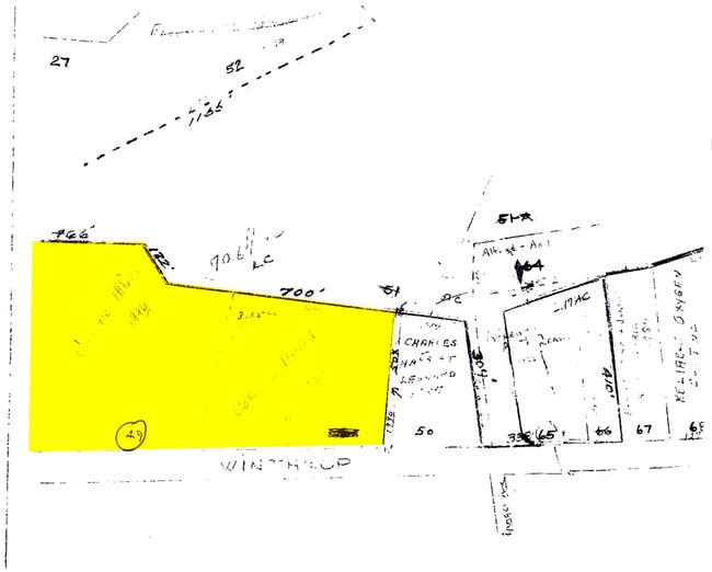
Property Record
490 Winthrop St, Taunton, MA 02780
NEARBY LISTINGS FOR SALE OR LEASE
-
-
View all Taunton listings for sale on LoopNet.com
Property Detail
490 Winthrop St
TAUN-000088-000085
Bristol
Officebuilding
Massachusetts
X
85
25005C0144F
3.56 AC
2025
Attleboro/New Bedford
2025
Boston
613400
Providence-Warwick, RI-MA
16,800 SF
DEMOGRAPHICS near 490 Winthrop St
1 mile
3 mile
5 mile
2024 Total Population
1,330
24,738
65,792
2029 Population
1,324
24,461
65,177
Pop Growth 2024-2029
(0.45%)
(1.12%)
(0.93%)
Average Age
42
41
41
2024 Total Households
485
9,742
25,708
HH Growth 2024-2029
(0.62%)
(1.18%)
(0.99%)
Median Household Inc
$125,309
$78,060
$72,655
Avg Household Size
2.70
2.50
2.50
2024 Avg HH Vehicles
2.00
2.00
2.00
Median Home Value
$439,423
$370,124
$377,137
Median Year Built
1991
1971
1968
Nearby Places
Map Layers
Map Styles
 Street
 Aerial
Transit
 Traffic
 Biking
Places
Listings with unknown addresses are not visible on the map
- Restaurants
- Banks
- Shops
- Fitness
- Groceries
PUBLIC TRANSPORTATION
AIRPORT
Rhode Island Tf Green International
Drive
Walk
Distance
Rhode Island Tf Green International
38 min
21.9 mi
General Edward Lawrence Logan International
Drive
Walk
Distance
General Edward Lawrence Logan International
62 min
43.7 mi
Nearby Properties
Address
Land Use
TOTAL SIZE
Lot Size
Zoning
Address
Land Use
TOTAL SIZE
Lot Size
Zoning
68,024 SF
66.24 AC
RURRES
Address
Land Use
TOTAL SIZE
Lot Size
Zoning
130,851 SF
24.43 AC
URBRES
Address
Land Use
TOTAL SIZE
Lot Size
Zoning
37.62 AC
URBRES
Address
Land Use
TOTAL SIZE
Lot Size
Zoning
5.20 AC
URBRES
Address
Land Use
TOTAL SIZE
Lot Size
Zoning
52,042 SF
59.53 AC
OPSPAC
Address
Land Use
TOTAL SIZE
Lot Size
Zoning
36,336 SF
6.35 AC
RURRES
Address
Land Use
TOTAL SIZE
Lot Size
Zoning
44,581 SF
14.60 AC
RURRES
Address
Land Use
TOTAL SIZE
Lot Size
Zoning
3 AC
URBRES
Address
Land Use
TOTAL SIZE
Lot Size
Zoning
24 AC
HIWABZ
Address
Land Use
TOTAL SIZE
Lot Size
Zoning
29,400 SF
12.91 AC
I
Address
Land Use
TOTAL SIZE
Lot Size
Zoning
4.53 AC
URBRES
Address
Land Use
TOTAL SIZE
Lot Size
Zoning
244,320 SF
13.66 AC
INDUST
Address
Land Use
TOTAL SIZE
Lot Size
Zoning
91,289 SF
3.82 AC
URBRES
Address
Land Use
TOTAL SIZE
Lot Size
Zoning
5,616 SF
10 AC
URBRES
Address
Land Use
TOTAL SIZE
Lot Size
Zoning
5.26 AC
URBRES
Address
Land Use
TOTAL SIZE
Lot Size
Zoning
120 AC
OPSPAC
Address
Land Use
TOTAL SIZE
Lot Size
Zoning
4,232 SF
74.05 AC
URBRES
Address
Land Use
TOTAL SIZE
Lot Size
Zoning
58,078 SF
6.10 AC
HIWABZ
Address
Land Use
TOTAL SIZE
Lot Size
Zoning
72,833 SF
6.98 AC
HIWABZ
Address
Land Use
TOTAL SIZE
Lot Size
Zoning
50 AC
URBRES
Address
Land Use
TOTAL SIZE
Lot Size
Zoning
132,574 SF
7.70 AC
RURRES
Address
Land Use
TOTAL SIZE
Lot Size
Zoning
46,744 SF
Address
Land Use
TOTAL SIZE
Lot Size
Zoning
10,080 SF
6.70 AC
R1
Address
Land Use
TOTAL SIZE
Lot Size
Zoning
35,717 SF
44 AC
I
Address
Land Use
TOTAL SIZE
Lot Size
Zoning
26,724 SF
1.44 AC
URBRES
Address
Land Use
TOTAL SIZE
Lot Size
Zoning
5,670 SF
7.12 AC
HIWABZ
Address
Land Use
TOTAL SIZE
Lot Size
Zoning
19,401 SF
1.40 AC
URBRES
Address
Land Use
TOTAL SIZE
Lot Size
Zoning
23,127 SF
1.14 AC
URBRES
Address
Land Use
TOTAL SIZE
Lot Size
Zoning
2.30 AC
URBRES
Address
Land Use
TOTAL SIZE
Lot Size
Zoning
45,938 SF
2.60 AC
URBRES
The World's #1 Commercial Real Estate Marketplace
Connect with us
© 2026 CoStar Group
The information above has been obtained from sources believed reliable. While we do not doubt its accuracy we have not verified it and make no guarantee, warranty or representation about it. It is your responsibility to independently confirm its accuracy and completeness. Any projections, opinions, assumptions, or estimates used are for example only and do not represent the current or future performance of the property. The value of this transaction to you depends on tax and other factors which should be evaluated by your tax, financial, and legal advisors. You and your advisors should conduct a careful, independent investigation of the property to determine to your satisfaction the suitability of the property for your needs.