Property Record
4900 Baymeadows Rd, Jacksonville, FL 32217
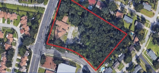


This Property Is For Sale
NEARBY LISTINGS FOR SALE OR LEASE
Property Detail
4900 Baymeadows Rd
148120-0100
Section Land
Religious
21-3S-27E 4.6 PT DORCAS BLACK DONATION,PT DAVID SCURRY GRANT SEC 37 RECD O/R 19496-917
X
Duval
12031C0551J
Florida
2025
4.60 AC
2026
Mandarin
016724
Jacksonville (Florida)
10,855 SF
Jacksonville, FL
DEMOGRAPHICS near 4900 Baymeadows Rd
1 mile
3 mile
5 mile
2024 Total Population
12,343
77,347
173,479
2029 Population
12,980
81,486
181,689
Pop Growth 2024-2029
+ 5.16%
+ 5.35%
+ 4.73%
Average Age
41
39
39
2024 Total Households
5,333
33,898
74,678
HH Growth 2024-2029
+ 5.12%
+ 5.59%
+ 4.89%
Median Household Inc
$64,652
$59,996
$65,860
Avg Household Size
2.30
2.20
2.20
2024 Avg HH Vehicles
2.00
2.00
2.00
Median Home Value
$271,599
$263,465
$268,532
Median Year Built
1983
1985
1987
Nearby Places
Map Layers
Map Styles
 Street
 Aerial
Transit
 Traffic
 Biking
Places
Listings with unknown addresses are not visible on the map
- Restaurants
- Banks
- Shops
- Fitness
- Groceries
PUBLIC TRANSPORTATION
AIRPORT
Jacksonville International
Drive
Walk
Distance
Jacksonville International
39 min
26.1 mi
Freight Ports
Jacksonville Port
Drive
Walk
Distance
Jacksonville Port
23 min
14.6 mi
Nearby Properties
Address
Land Use
TOTAL SIZE
Lot Size
Zoning
Address
Land Use
TOTAL SIZE
Lot Size
Zoning
1,159,855 SF
89.44 AC
RMD-D
Address
Land Use
TOTAL SIZE
Lot Size
Zoning
251,691 SF
17.51 AC
PUD
Address
Land Use
TOTAL SIZE
Lot Size
Zoning
478,012 SF
29.87 AC
PUD
Address
Land Use
TOTAL SIZE
Lot Size
Zoning
371,466 SF
49.16 AC
PBF-2
Address
Land Use
TOTAL SIZE
Lot Size
Zoning
209,436 SF
14.38 AC
PUD
Address
Land Use
TOTAL SIZE
Lot Size
Zoning
273,196 SF
16.57 AC
PUD
Address
Land Use
TOTAL SIZE
Lot Size
Zoning
217,557 SF
14.72 AC
PUD
Address
Land Use
TOTAL SIZE
Lot Size
Zoning
446,326 SF
23.68 AC
RMD-D
Address
Land Use
TOTAL SIZE
Lot Size
Zoning
464,189 SF
44.85 AC
RMD-D
Address
Land Use
TOTAL SIZE
Lot Size
Zoning
316,705 SF
15.44 AC
PUD
Address
Land Use
TOTAL SIZE
Lot Size
Zoning
250,989 SF
19.48 AC
PUD
Address
Land Use
TOTAL SIZE
Lot Size
Zoning
358,537 SF
29.16 AC
RMD-C
Address
Land Use
TOTAL SIZE
Lot Size
Zoning
193,941 SF
7.35 AC
PUD
Address
Land Use
TOTAL SIZE
Lot Size
Zoning
266,087 SF
35.07 AC
RMD-D
Address
Land Use
TOTAL SIZE
Lot Size
Zoning
365,629 SF
23.23 AC
RMD-D
Address
Land Use
TOTAL SIZE
Lot Size
Zoning
307,396 SF
24.45 AC
PUD
Address
Land Use
TOTAL SIZE
Lot Size
Zoning
348,919 SF
18.08 AC
RMD-D
Address
Land Use
TOTAL SIZE
Lot Size
Zoning
325,848 SF
25.78 AC
RMD-C
Address
Land Use
TOTAL SIZE
Lot Size
Zoning
313,009 SF
22.50 AC
RMD-D
Address
Land Use
TOTAL SIZE
Lot Size
Zoning
415,146 SF
19.27 AC
RMD-D
Address
Land Use
TOTAL SIZE
Lot Size
Zoning
236,068 SF
18.87 AC
PUD
Address
Land Use
TOTAL SIZE
Lot Size
Zoning
286,223 SF
28.01 AC
PBF-2
Address
Land Use
TOTAL SIZE
Lot Size
Zoning
320,407 SF
32.91 AC
RMD-C
Address
Land Use
TOTAL SIZE
Lot Size
Zoning
310,849 SF
16.16 AC
RMD-C
Address
Land Use
TOTAL SIZE
Lot Size
Zoning
294,353 SF
14.58 AC
RMD-D
Address
Land Use
TOTAL SIZE
Lot Size
Zoning
169,086 SF
10.01 AC
PUD
Address
Land Use
TOTAL SIZE
Lot Size
Zoning
236,617 SF
16.38 AC
RMD-D
Address
Land Use
TOTAL SIZE
Lot Size
Zoning
278,282 SF
20.45 AC
RMD-D
Address
Land Use
TOTAL SIZE
Lot Size
Zoning
387,821 SF
32.10 AC
IBP
Address
Land Use
TOTAL SIZE
Lot Size
Zoning
327,854 SF
26.24 AC
RMD-D
The World's #1 Commercial Real Estate Marketplace
Connect with us
© 2026 CoStar Group
The information above has been obtained from sources believed reliable. While we do not doubt its accuracy we have not verified it and make no guarantee, warranty or representation about it. It is your responsibility to independently confirm its accuracy and completeness. Any projections, opinions, assumptions, or estimates used are for example only and do not represent the current or future performance of the property. The value of this transaction to you depends on tax and other factors which should be evaluated by your tax, financial, and legal advisors. You and your advisors should conduct a careful, independent investigation of the property to determine to your satisfaction the suitability of the property for your needs.