Property Record
4900 Highway 2 And 52 W, Minot, ND 58701


NEARBY LISTINGS FOR SALE OR LEASE
-
-
View all Minot listings for sale on LoopNet.com
Property Detail
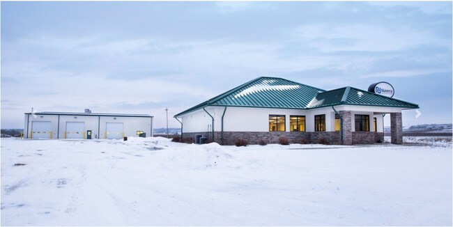
4900 Highway 2 And 52 W
Other Market Areas
Energy Park West
Minot, ND
Ward
HA-20111-000-007-0
North Dakota
Singlefamilyresidentialassumed
20 AC
5,768 SF
Souris Valley
DEMOGRAPHICS near 4900 Highway 2 And 52 W
1 Mile
3 Mile
5 Mile
2024 Total Population
211
19,662
49,431
2029 Population
208
19,214
48,675
Pop Growth 2024-2029
(1.42%)
(2.28%)
(1.53%)
Average Age
39
38
38
2024 Total Households
83
8,043
21,217
HH Growth 2024-2029
(2.41%)
(2.39%)
(1.57%)
Median Household Inc
$71,785
$74,939
$69,318
Avg Household Size
2.50
2.40
2.20
2024 Avg HH Vehicles
3.00
2.00
2.00
Median Home Value
$323,077
$251,944
$236,146
Median Year Built
1997
1981
1982
Nearby Places
Map Layers
Map Styles
 Street
 Aerial
- Restaurants
- Banks
- Shops
- Fitness
- Groceries
PUBLIC TRANSPORTATION
COMMUTER RAIL
Minot Amtrak Station (Empire Builder - Amtrak)
DRIVE
WALK
Distance
Minot Amtrak Station (Empire Builder - Amtrak)
7 min
4.8 mi
AIRPORT
Minot International
DRIVE
WALK
Distance
Minot International
12 min
7.1 mi
Freight Ports
Port Milwaukee
DRIVE
WALK
Distance
Port Milwaukee
946 min
874.1 mi
SALE & LEASE HISTORY
LISTING DATE
SALE/LEASE

Mar 19, 2019
For Sale
Jan 03, 2020
For Sale
Jan 02, 2020
For Lease
Nearby Properties
Address
Land Use
TOTAL SIZE
Lot Size
Zoning
Address
Land Use
TOTAL SIZE
Lot Size
Zoning
142,655 SF
9.54 AC
Address
Land Use
TOTAL SIZE
Lot Size
Zoning
55,908 SF
5.89 AC
Address
Land Use
TOTAL SIZE
Lot Size
Zoning
121,307 SF
2.97 AC
Address
Land Use
TOTAL SIZE
Lot Size
Zoning
29,172 SF
9.19 AC
Address
Land Use
TOTAL SIZE
Lot Size
Zoning
14,400 SF
4.46 AC
Address
Land Use
TOTAL SIZE
Lot Size
Zoning
39,667 SF
0.02 AC
Address
Land Use
TOTAL SIZE
Lot Size
Zoning
9.49 AC
Address
Land Use
TOTAL SIZE
Lot Size
Zoning
55,520 SF
2.50 AC
Address
Land Use
TOTAL SIZE
Lot Size
Zoning
8,060 SF
1.02 AC
Address
Land Use
TOTAL SIZE
Lot Size
Zoning
6,868 SF
1.52 AC
Address
Land Use
TOTAL SIZE
Lot Size
Zoning
7,222 SF
3.07 AC
Address
Land Use
TOTAL SIZE
Lot Size
Zoning
36,633 SF
2.07 AC
Address
Land Use
TOTAL SIZE
Lot Size
Zoning
38,721 SF
1.60 AC
Address
Land Use
TOTAL SIZE
Lot Size
Zoning
5,760 SF
52.59 AC
Address
Land Use
TOTAL SIZE
Lot Size
Zoning
9,844 SF
1.27 AC
Address
Land Use
TOTAL SIZE
Lot Size
Zoning
15,000 SF
4.57 AC
Address
Land Use
TOTAL SIZE
Lot Size
Zoning
15.84 AC
Address
Land Use
TOTAL SIZE
Lot Size
Zoning
3,894 SF
0.62 AC
Address
Land Use
TOTAL SIZE
Lot Size
Zoning
10,142 SF
0.62 AC
Address
Land Use
TOTAL SIZE
Lot Size
Zoning
1.61 AC
Address
Land Use
TOTAL SIZE
Lot Size
Zoning
12.18 AC
Address
Land Use
TOTAL SIZE
Lot Size
Zoning
3,767 SF
0.47 AC
Address
Land Use
TOTAL SIZE
Lot Size
Zoning
1,600 SF
2.01 AC
Address
Land Use
TOTAL SIZE
Lot Size
Zoning
10,800 SF
2 AC
Address
Land Use
TOTAL SIZE
Lot Size
Zoning
1.44 AC
Address
Land Use
TOTAL SIZE
Lot Size
Zoning
5,525 SF
0.63 AC
Address
Land Use
TOTAL SIZE
Lot Size
Zoning
2.28 AC
Address
Land Use
TOTAL SIZE
Lot Size
Zoning
2.15 AC
Address
Land Use
TOTAL SIZE
Lot Size
Zoning
2.12 AC
The World's #1 Commercial Real Estate Marketplace
Connect with us
© 2026 CoStar Group
The information above has been obtained from sources believed reliable. While we do not doubt its accuracy we have not verified it and make no guarantee, warranty or representation about it. It is your responsibility to independently confirm its accuracy and completeness. Any projections, opinions, assumptions, or estimates used are for example only and do not represent the current or future performance of the property. The value of this transaction to you depends on tax and other factors which should be evaluated by your tax, financial, and legal advisors. You and your advisors should conduct a careful, independent investigation of the property to determine to your satisfaction the suitability of the property for your needs.