Property Record
4900 Jaybird Rd, Brighton, AL 35020
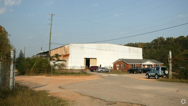

Property Detail
4900 Jaybird Rd
30-00-28-4-001-003.000
COM AT NE COR OF SE1/4 OF SEC 28 TWSP 18S R 4W TH S 392 FT TO PT ON W BDRY OF JAYBIRD RD R/W & POB TH CONT W 132.5 FT TH N 118 FT TH W 112.6 FT TH S 180 FT TH SE 180 FT TH E 1185 FT TH N 207 FT TO POB
Warehouse
Jefferson
I3
Alabama
B and X Area of moderate flood hazard, usually the area between the limits of the 100-year and 500-year floods.
8 AC
2024
Bessemer
2025
Birmingham
013801
Birmingham, AL
46,020 SF
NEARBY LISTINGS FOR SALE OR LEASE
DEMOGRAPHICS near 4900 Jaybird Rd
1 mile
3 mile
5 mile
2025 Total Population
2,796
39,189
91,149
2030 Population
2,805
39,043
90,962
Pop Growth 2025-2030
+ 0.32%
(0.37%)
(0.21%)
Average Age
41
41
40
2025 Total Households
1,158
15,502
36,698
HH Growth 2025-2030
+ 0.35%
(0.42%)
(0.27%)
Median Household Inc
$36,700
$47,728
$49,198
Avg Household Size
2.30
2.40
2.40
2025 Avg HH Vehicles
1.00
2.00
2.00
Median Home Value
$67,307
$133,299
$135,739
Median Year Built
1958
1964
1965
Nearby Places
Map Layers
Map Styles
 Street
 Aerial
Layers
 Traffic
 Biking
Places
Listings with unknown addresses are not visible on the map
- Restaurants
- Banks
- Shops
- Fitness
- Groceries
PUBLIC TRANSPORTATION
AIRPORT
Birmingham-Shuttlesworth International
Drive
Walk
Distance
Birmingham-Shuttlesworth International
23 min
16.6 mi
Nearby Properties
Address
Land Use
TOTAL SIZE
Lot Size
Zoning
Address
Land Use
TOTAL SIZE
Lot Size
Zoning
2,573,547 SF
112 AC
I2
Address
Land Use
TOTAL SIZE
Lot Size
Zoning
1,244,986 SF
I2
Address
Land Use
TOTAL SIZE
Lot Size
Zoning
195,495 SF
29 AC
B3
Address
Land Use
TOTAL SIZE
Lot Size
Zoning
553,137 SF
87 AC
I2
Address
Land Use
TOTAL SIZE
Lot Size
Zoning
460,483 SF
20 AC
I3
Address
Land Use
TOTAL SIZE
Lot Size
Zoning
145,300 SF
25 AC
R3
Address
Land Use
TOTAL SIZE
Lot Size
Zoning
136,115 SF
15 AC
C3
Address
Land Use
TOTAL SIZE
Lot Size
Zoning
191,664 SF
15 AC
R4
Address
Land Use
TOTAL SIZE
Lot Size
Zoning
288,000 SF
39.40 AC
I2-I
Address
Land Use
TOTAL SIZE
Lot Size
Zoning
219,210 SF
19 AC
M2
Address
Land Use
TOTAL SIZE
Lot Size
Zoning
230,088 SF
I3
Address
Land Use
TOTAL SIZE
Lot Size
Zoning
130,563 SF
I3
Address
Land Use
TOTAL SIZE
Lot Size
Zoning
66,928 SF
3.10 AC
B2-R
Address
Land Use
TOTAL SIZE
Lot Size
Zoning
77,902 SF
44 AC
I3
Address
Land Use
TOTAL SIZE
Lot Size
Zoning
1,090,237 SF
28.10 AC
I4
Address
Land Use
TOTAL SIZE
Lot Size
Zoning
66,900 SF
3.78 AC
I4
Address
Land Use
TOTAL SIZE
Lot Size
Zoning
58,822 SF
7.80 AC
B3
Address
Land Use
TOTAL SIZE
Lot Size
Zoning
69,344 SF
2 AC
B-1
Address
Land Use
TOTAL SIZE
Lot Size
Zoning
1,200 SF
14 AC
R3
Address
Land Use
TOTAL SIZE
Lot Size
Zoning
104,775 SF
9 AC
B-2
Address
Land Use
TOTAL SIZE
Lot Size
Zoning
366,421 SF
21 AC
I3
Address
Land Use
TOTAL SIZE
Lot Size
Zoning
1,437,077 SF
I2
Address
Land Use
TOTAL SIZE
Lot Size
Zoning
80,043 SF
11 AC
B3-C
Address
Land Use
TOTAL SIZE
Lot Size
Zoning
96,543 SF
9 AC
B2
Address
Land Use
TOTAL SIZE
Lot Size
Zoning
163,056 SF
I-3
Address
Land Use
TOTAL SIZE
Lot Size
Zoning
49,022 SF
5.50 AC
R2
Address
Land Use
TOTAL SIZE
Lot Size
Zoning
43,674 SF
3.25 AC
C3
Address
Land Use
TOTAL SIZE
Lot Size
Zoning
80,220 SF
7 AC
M2
Address
Land Use
TOTAL SIZE
Lot Size
Zoning
40,098 SF
0.48 AC
C1
Address
Land Use
TOTAL SIZE
Lot Size
Zoning
65,232 SF
4 AC
R-5
The World's #1 Commercial Real Estate Marketplace
Connect with us
© 2026 CoStar Group
The information above has been obtained from sources believed reliable. While we do not doubt its accuracy we have not verified it and make no guarantee, warranty or representation about it. It is your responsibility to independently confirm its accuracy and completeness. Any projections, opinions, assumptions, or estimates used are for example only and do not represent the current or future performance of the property. The value of this transaction to you depends on tax and other factors which should be evaluated by your tax, financial, and legal advisors. You and your advisors should conduct a careful, independent investigation of the property to determine to your satisfaction the suitability of the property for your needs.