Property Record
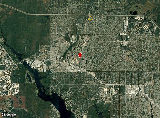
4900 S Sumter Blvd, North Port, FL 34287
NEARBY LISTINGS FOR SALE OR LEASE
Property Detail
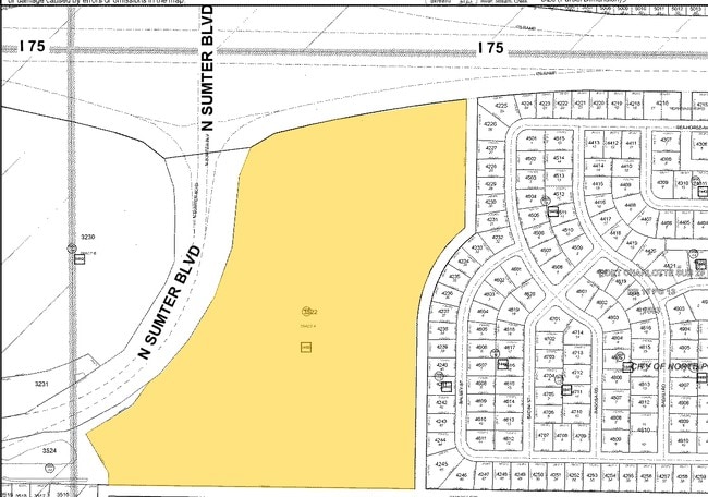
4900 S Sumter Blvd
North Port-Sarasota-Bradenton, FL
Port Charlotte Sub 29
0956-14-3522
PORTION OF TRACT A, 29TH ADD TO PORT CHARLOTTE, BEING DESC AS, BEG AT SE COR OF SAID TRACT A TH N 89-11-53 W ALONG S LINE OF SAID TRACT A 1355.05 FT TO R/W LINE OF SUMTER BLVD TH ALONG SAID R/W LINE
Vacantlandnec
Sarasota
AE
Florida
12115C0377F
a
0
32 AC
2025
Sarasota Outlying
002743
Tampa/St Petersburg
DEMOGRAPHICS near 4900 S Sumter Blvd
1 Mile
3 Mile
5 Mile
2024 Total Population
3,297
26,180
63,973
2029 Population
3,761
29,844
73,366
Pop Growth 2024-2029
+ 14.07%
+ 14.00%
+ 14.68%
Average Age
40
42
44
2024 Total Households
1,159
9,527
24,972
HH Growth 2024-2029
+ 13.89%
+ 13.95%
+ 14.66%
Median Household Inc
$67,709
$73,226
$68,110
Avg Household Size
2.80
2.70
2.50
2024 Avg HH Vehicles
2.00
2.00
2.00
Median Home Value
$213,115
$248,043
$242,454
Median Year Built
2001
2002
2001
Nearby Places
Map Layers
Map Styles
 Street
 Aerial
- Restaurants
- Banks
- Shops
- Fitness
- Groceries
PUBLIC TRANSPORTATION
AIRPORT
Punta Gorda
DRIVE
WALK
Distance
Punta Gorda
33 min
18.3 mi
Freight Ports
Port Manatee
DRIVE
WALK
Distance
Port Manatee
69 min
56.3 mi
Nearby Properties
Address
Land Use
TOTAL SIZE
Lot Size
Zoning
Address
Land Use
TOTAL SIZE
Lot Size
Zoning
548,781 SF
196.98 AC
GU
Address
Land Use
TOTAL SIZE
Lot Size
Zoning
218,356 SF
17.14 AC
AC2
Address
Land Use
TOTAL SIZE
Lot Size
Zoning
267,412 SF
23.26 AC
AC1
Address
Land Use
TOTAL SIZE
Lot Size
Zoning
146,932 SF
39.48 AC
AC2
Address
Land Use
TOTAL SIZE
Lot Size
Zoning
302,632 SF
15.71 AC
AC2
Address
Land Use
TOTAL SIZE
Lot Size
Zoning
205,624 SF
21.37 AC
AC1
Address
Land Use
TOTAL SIZE
Lot Size
Zoning
9,511 SF
40.53 AC
PD
Address
Land Use
TOTAL SIZE
Lot Size
Zoning
114,985 SF
29.77 AC
GU
Address
Land Use
TOTAL SIZE
Lot Size
Zoning
103,327 SF
47.54 AC
GU
Address
Land Use
TOTAL SIZE
Lot Size
Zoning
101,676 SF
8.83 AC
AC1
Address
Land Use
TOTAL SIZE
Lot Size
Zoning
79,944 SF
15.64 AC
AC1
Address
Land Use
TOTAL SIZE
Lot Size
Zoning
155,080 SF
8.96 AC
CG
Address
Land Use
TOTAL SIZE
Lot Size
Zoning
196,163 SF
15.60 AC
AC1
Address
Land Use
TOTAL SIZE
Lot Size
Zoning
142,364 SF
13.87 AC
AC1
Address
Land Use
TOTAL SIZE
Lot Size
Zoning
40,161 SF
40 AC
GU
Address
Land Use
TOTAL SIZE
Lot Size
Zoning
65,103 SF
10.16 AC
AC2
Address
Land Use
TOTAL SIZE
Lot Size
Zoning
18.49 AC
PCDN
Address
Land Use
TOTAL SIZE
Lot Size
Zoning
85,529 SF
11.41 AC
AC1
Address
Land Use
TOTAL SIZE
Lot Size
Zoning
105,046 SF
12.69 AC
AC1
Address
Land Use
TOTAL SIZE
Lot Size
Zoning
115,678 SF
8.58 AC
R3
Address
Land Use
TOTAL SIZE
Lot Size
Zoning
42,923 SF
403.06 AC
R1
Address
Land Use
TOTAL SIZE
Lot Size
Zoning
63,016 SF
2.56 AC
AC1
Address
Land Use
TOTAL SIZE
Lot Size
Zoning
14,714 SF
81.28 AC
AC7B
Address
Land Use
TOTAL SIZE
Lot Size
Zoning
43,387 SF
5.09 AC
AC2
Address
Land Use
TOTAL SIZE
Lot Size
Zoning
22.07 AC
PD
Address
Land Use
TOTAL SIZE
Lot Size
Zoning
289,861 SF
27.47 AC
AC2
Address
Land Use
TOTAL SIZE
Lot Size
Zoning
19,816 SF
2.70 AC
AC2
Address
Land Use
TOTAL SIZE
Lot Size
Zoning
17.48 AC
AC1
Address
Land Use
TOTAL SIZE
Lot Size
Zoning
10,721 SF
3 AC
PD
Address
Land Use
TOTAL SIZE
Lot Size
Zoning
29,890 SF
7.78 AC
R3
The World's #1 Commercial Real Estate Marketplace
Connect with us
© 2025 CoStar Group
The information above has been obtained from sources believed reliable. While we do not doubt its accuracy we have not verified it and make no guarantee, warranty or representation about it. It is your responsibility to independently confirm its accuracy and completeness. Any projections, opinions, assumptions, or estimates used are for example only and do not represent the current or future performance of the property. The value of this transaction to you depends on tax and other factors which should be evaluated by your tax, financial, and legal advisors. You and your advisors should conduct a careful, independent investigation of the property to determine to your satisfaction the suitability of the property for your needs.