Property Record
4900 Rosebud Dr Sw, Snellville, GA 30039

Property Detail
4900 Rosebud Dr Sw
Atlanta-Sandy Springs-Roswell, GA
ROSEBUD DR
4-321-002
GWINNETT
Commercialacreage
Georgia
C1
1
B and X Area of moderate flood hazard, usually the area between the limits of the 100-year and 500-year floods.
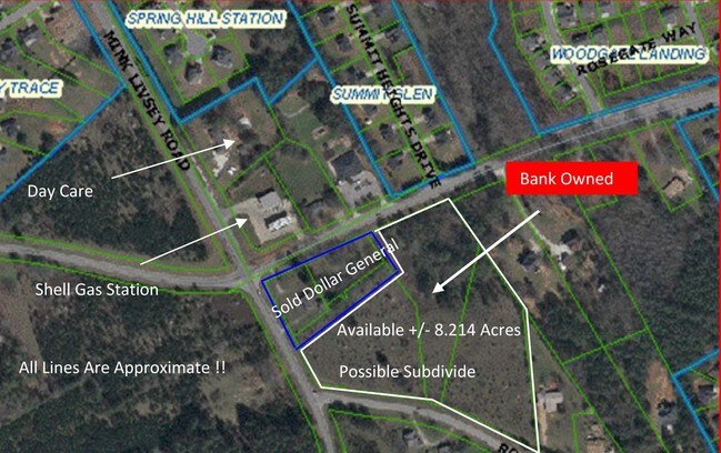
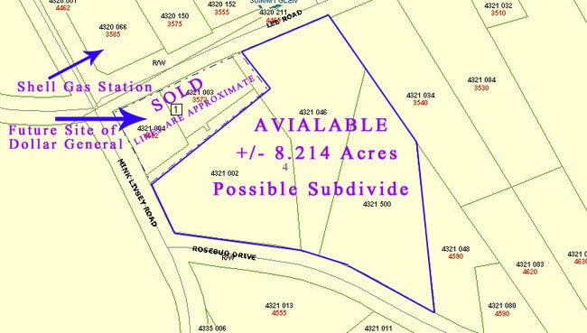
5.55 AC
2025
Lawrenceville/Lilburn
2025
Atlanta
050738
NEARBY LISTINGS FOR SALE OR LEASE
DEMOGRAPHICS near 4900 Rosebud Dr Sw
1 mile
3 mile
5 mile
2025 Total Population
6,181
34,017
96,828
2030 Population
6,419
35,520
100,887
Pop Growth 2025-2030
+ 3.85%
+ 4.42%
+ 4.19%
Average Age
37
38
38
2025 Total Households
1,895
10,842
31,547
HH Growth 2025-2030
+ 3.96%
+ 4.51%
+ 4.26%
Median Household Inc
$88,134
$86,183
$87,477
Avg Household Size
3.20
3.10
3.00
2025 Avg HH Vehicles
2.00
2.00
2.00
Median Home Value
$358,346
$352,795
$340,820
Median Year Built
2001
1999
1992
Nearby Places
Map Layers
Map Styles
 Street
 Aerial
Transit
 Traffic
 Biking
Places
Listings with unknown addresses are not visible on the map
- Restaurants
- Banks
- Shops
- Fitness
- Groceries
PUBLIC TRANSPORTATION
AIRPORT
Hartsfield - Jackson Atlanta International
Drive
Walk
Distance
Hartsfield - Jackson Atlanta International
48 min
32.0 mi
Freight Ports
Georgia Ports - Savannah
Drive
Walk
Distance
Georgia Ports - Savannah
292 min
248.9 mi
Nearby Properties
Address
Land Use
TOTAL SIZE
Lot Size
Zoning
Address
Land Use
TOTAL SIZE
Lot Size
Zoning
129,843 SF
30.97 AC
R100
Address
Land Use
TOTAL SIZE
Lot Size
Zoning
23,692 SF
112.46 AC
RA200
Address
Land Use
TOTAL SIZE
Lot Size
Zoning
54.06 AC
R100
Address
Land Use
TOTAL SIZE
Lot Size
Zoning
151,922 SF
18.19 AC
R100
Address
Land Use
TOTAL SIZE
Lot Size
Zoning
90,151 SF
2.38 AC
C2
Address
Land Use
TOTAL SIZE
Lot Size
Zoning
350.63 AC
R100
Address
Land Use
TOTAL SIZE
Lot Size
Zoning
1,296 SF
65.93 AC
R100
Address
Land Use
TOTAL SIZE
Lot Size
Zoning
42,183 SF
11.87 AC
C2
Address
Land Use
TOTAL SIZE
Lot Size
Zoning
18,420 SF
13.92 AC
OI
Address
Land Use
TOTAL SIZE
Lot Size
Zoning
26,866 SF
8.21 AC
OI
Address
Land Use
TOTAL SIZE
Lot Size
Zoning
36.74 AC
R100
Address
Land Use
TOTAL SIZE
Lot Size
Zoning
20,812 SF
16.29 AC
R100
Address
Land Use
TOTAL SIZE
Lot Size
Zoning
2,400 SF
10.77 AC
R100
Address
Land Use
TOTAL SIZE
Lot Size
Zoning
7,664 SF
1.32 AC
C1
Address
Land Use
TOTAL SIZE
Lot Size
Zoning
6,000 SF
2 AC
C1
Address
Land Use
TOTAL SIZE
Lot Size
Zoning
14,900 SF
6.68 AC
R100
Address
Land Use
TOTAL SIZE
Lot Size
Zoning
8,052 SF
9.44 AC
R100
Address
Land Use
TOTAL SIZE
Lot Size
Zoning
9,504 SF
0.81 AC
C1
Address
Land Use
TOTAL SIZE
Lot Size
Zoning
100.56 AC
R100
Address
Land Use
TOTAL SIZE
Lot Size
Zoning
9,420 SF
3.29 AC
C1
Address
Land Use
TOTAL SIZE
Lot Size
Zoning
4,352 SF
8.74 AC
R100
Address
Land Use
TOTAL SIZE
Lot Size
Zoning
9,376 SF
2.63 AC
C2
Address
Land Use
TOTAL SIZE
Lot Size
Zoning
7,858 SF
7.69 AC
R100
Address
Land Use
TOTAL SIZE
Lot Size
Zoning
5,500 SF
1.56 AC
C1
Address
Land Use
TOTAL SIZE
Lot Size
Zoning
13,445 SF
5.14 AC
C2
Address
Land Use
TOTAL SIZE
Lot Size
Zoning
3,800 SF
1.70 AC
C2
Address
Land Use
TOTAL SIZE
Lot Size
Zoning
6,600 SF
4.95 AC
C1
Address
Land Use
TOTAL SIZE
Lot Size
Zoning
2,856 SF
13.06 AC
A1
Address
Land Use
TOTAL SIZE
Lot Size
Zoning
2,790 SF
51.37 AC
R100
Address
Land Use
TOTAL SIZE
Lot Size
Zoning
4,696 SF
3.70 AC
C1
The World's #1 Commercial Real Estate Marketplace
Connect with us
© 2026 CoStar Group
The information above has been obtained from sources believed reliable. While we do not doubt its accuracy we have not verified it and make no guarantee, warranty or representation about it. It is your responsibility to independently confirm its accuracy and completeness. Any projections, opinions, assumptions, or estimates used are for example only and do not represent the current or future performance of the property. The value of this transaction to you depends on tax and other factors which should be evaluated by your tax, financial, and legal advisors. You and your advisors should conduct a careful, independent investigation of the property to determine to your satisfaction the suitability of the property for your needs.