Property Record
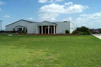
4901 E Grimes St, Harlingen, TX 78550

Property Detail
4901 E Grimes St
972310-0000-001000
HARLINGEN - C T O SUBD PT LOT 1, 4.01 ACRES
Commercialnec
Cameron
C
Texas
B and X Area of moderate flood hazard, usually the area between the limits of the 100-year and 500-year floods.
1,4
2024
4.01 AC
2025
Greater Harlingen
010802
Brownsville/Harlingen
9,840 SF
Brownsville-Harlingen, TX
NEARBY LISTINGS FOR SALE OR LEASE
DEMOGRAPHICS near 4901 E Grimes St
1 mile
3 mile
5 mile
2025 Total Population
548
30,230
80,042
2030 Population
598
30,735
81,692
Pop Growth 2025-2030
+ 9.12%
+ 1.67%
+ 2.06%
Average Age
33
37
38
2025 Total Households
118
10,602
27,359
HH Growth 2025-2030
+ 11.02%
+ 1.63%
+ 2.09%
Median Household Inc
$44,999
$55,168
$50,766
Avg Household Size
2.80
2.70
2.80
2025 Avg HH Vehicles
1.00
2.00
2.00
Median Home Value
$223,529
$172,328
$134,487
Median Year Built
1996
1983
1984
Nearby Places
Map Layers
Map Styles
 Street
 Aerial
Transit
 Traffic
 Biking
Places
Listings with unknown addresses are not visible on the map
- Restaurants
- Banks
- Shops
- Fitness
- Groceries
PUBLIC TRANSPORTATION
AIRPORT
Valley International
Drive
Walk
Distance
Valley International
8 min
2.8 mi
Brownsville/South Padre Island International
Drive
Walk
Distance
Brownsville/South Padre Island International
42 min
29.6 mi
Freight Ports
Port of Brownsville
Drive
Walk
Distance
Port of Brownsville
35 min
27.2 mi
Nearby Properties
Address
Land Use
TOTAL SIZE
Lot Size
Zoning
Address
Land Use
TOTAL SIZE
Lot Size
Zoning
758,640 SF
11.31 AC
Address
Land Use
TOTAL SIZE
Lot Size
Zoning
427,448 SF
6.94 AC
Address
Land Use
TOTAL SIZE
Lot Size
Zoning
663,572 SF
60.74 AC
I
Address
Land Use
TOTAL SIZE
Lot Size
Zoning
293,886 SF
23.57 AC
Address
Land Use
TOTAL SIZE
Lot Size
Zoning
100,090 SF
15 AC
Address
Land Use
TOTAL SIZE
Lot Size
Zoning
148,596 SF
1 AC
Address
Land Use
TOTAL SIZE
Lot Size
Zoning
134,518 SF
10.01 AC
Address
Land Use
TOTAL SIZE
Lot Size
Zoning
118,561 SF
6.32 AC
C
Address
Land Use
TOTAL SIZE
Lot Size
Zoning
15,085 SF
51.10 AC
C
Address
Land Use
TOTAL SIZE
Lot Size
Zoning
16,508 SF
347.82 AC
Address
Land Use
TOTAL SIZE
Lot Size
Zoning
61,920 SF
5.60 AC
C
Address
Land Use
TOTAL SIZE
Lot Size
Zoning
76,756 SF
15.35 AC
Address
Land Use
TOTAL SIZE
Lot Size
Zoning
20,062 SF
47.54 AC
C
Address
Land Use
TOTAL SIZE
Lot Size
Zoning
230,267 SF
7.85 AC
C
Address
Land Use
TOTAL SIZE
Lot Size
Zoning
180,838 SF
12.56 AC
C
Address
Land Use
TOTAL SIZE
Lot Size
Zoning
90,376 SF
1.93 AC
Address
Land Use
TOTAL SIZE
Lot Size
Zoning
176,627 SF
12.45 AC
A-C
Address
Land Use
TOTAL SIZE
Lot Size
Zoning
145,232 SF
6.38 AC
Address
Land Use
TOTAL SIZE
Lot Size
Zoning
84,936 SF
12 AC
Address
Land Use
TOTAL SIZE
Lot Size
Zoning
188,102 SF
45.81 AC
C
Address
Land Use
TOTAL SIZE
Lot Size
Zoning
93,459 SF
20 AC
Address
Land Use
TOTAL SIZE
Lot Size
Zoning
7,600 SF
16.94 AC
Address
Land Use
TOTAL SIZE
Lot Size
Zoning
45,408 SF
12 AC
Address
Land Use
TOTAL SIZE
Lot Size
Zoning
130,347 SF
4.04 AC
Address
Land Use
TOTAL SIZE
Lot Size
Zoning
73,926 SF
4.39 AC
Address
Land Use
TOTAL SIZE
Lot Size
Zoning
105,000 SF
9.15 AC
C
Address
Land Use
TOTAL SIZE
Lot Size
Zoning
93,613 SF
4.20 AC
C
Address
Land Use
TOTAL SIZE
Lot Size
Zoning
95,867 SF
11.11 AC
C
Address
Land Use
TOTAL SIZE
Lot Size
Zoning
18.61 AC
C
The World's #1 Commercial Real Estate Marketplace
Connect with us
© 2026 CoStar Group
The information above has been obtained from sources believed reliable. While we do not doubt its accuracy we have not verified it and make no guarantee, warranty or representation about it. It is your responsibility to independently confirm its accuracy and completeness. Any projections, opinions, assumptions, or estimates used are for example only and do not represent the current or future performance of the property. The value of this transaction to you depends on tax and other factors which should be evaluated by your tax, financial, and legal advisors. You and your advisors should conduct a careful, independent investigation of the property to determine to your satisfaction the suitability of the property for your needs.