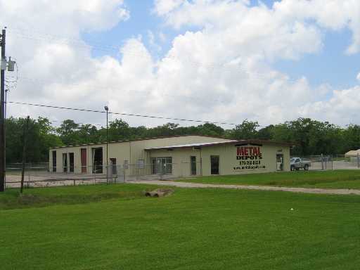
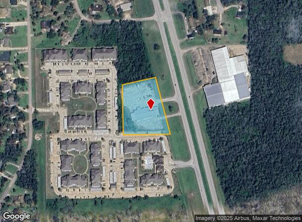
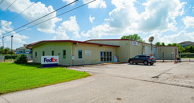
Property Record
4901 N Highway 288B Blvd N, Richwood, TX 77531
NEARBY LISTINGS FOR SALE OR LEASE
Property Detail
4901 N Highway 288B Blvd N
0066-0360-000
J E Groce
Commercialnec
A0066 J E GROCE TRACT 110E ACRES 2.3774
AE
Brazoria
48039C0610K
Texas
2024
2.38 AC
2025
Southwest Far
663800
Houston
11,008 SF
Houston-The Woodlands-Sugar Land, TX
DEMOGRAPHICS near 4901 N Highway 288B Blvd N
1 Mile
3 Mile
5 Mile
2024 Total Population
2,630
18,661
57,683
2029 Population
2,994
20,836
64,672
Pop Growth 2024-2029
+ 13.84%
+ 11.66%
+ 12.12%
Average Age
37
38
38
2024 Total Households
985
6,840
21,607
HH Growth 2024-2029
+ 14.01%
+ 11.87%
+ 12.53%
Median Household Inc
$71,292
$100,567
$75,262
Avg Household Size
2.60
2.70
2.60
2024 Avg HH Vehicles
2.00
2.00
2.00
Median Home Value
$245,685
$248,191
$215,785
Median Year Built
1992
1983
1983
Nearby Places
Map Layers
Map Styles
 Street
 Aerial
- Restaurants
- Banks
- Shops
- Fitness
- Groceries
SALE & LEASE HISTORY
LISTING DATE
SALE/LEASE

Oct 19, 2021
For Sale
Nearby Properties
Address
Land Use
TOTAL SIZE
Lot Size
Zoning
Address
Land Use
TOTAL SIZE
Lot Size
Zoning
13.41 AC
Address
Land Use
TOTAL SIZE
Lot Size
Zoning
250,134 SF
17 AC
Address
Land Use
TOTAL SIZE
Lot Size
Zoning
98.38 AC
0182
Address
Land Use
TOTAL SIZE
Lot Size
Zoning
123,012 SF
13.36 AC
Address
Land Use
TOTAL SIZE
Lot Size
Zoning
240,930 SF
12.24 AC
Address
Land Use
TOTAL SIZE
Lot Size
Zoning
253,899 SF
11.75 AC
Address
Land Use
TOTAL SIZE
Lot Size
Zoning
90,104 SF
45.22 AC
0180
Address
Land Use
TOTAL SIZE
Lot Size
Zoning
101,816 SF
15.79 AC
Address
Land Use
TOTAL SIZE
Lot Size
Zoning
100,098 SF
4.91 AC
Address
Land Use
TOTAL SIZE
Lot Size
Zoning
67,544 SF
15 AC
0181
Address
Land Use
TOTAL SIZE
Lot Size
Zoning
51,250 SF
4.51 AC
Address
Land Use
TOTAL SIZE
Lot Size
Zoning
94,593 SF
8.37 AC
Address
Land Use
TOTAL SIZE
Lot Size
Zoning
56,999 SF
0.62 AC
Address
Land Use
TOTAL SIZE
Lot Size
Zoning
17,007 SF
13.60 AC
0021
Address
Land Use
TOTAL SIZE
Lot Size
Zoning
89,950 SF
4 AC
0207
Address
Land Use
TOTAL SIZE
Lot Size
Zoning
16,520 SF
3.20 AC
Address
Land Use
TOTAL SIZE
Lot Size
Zoning
82,220 SF
5.84 AC
0004
Address
Land Use
TOTAL SIZE
Lot Size
Zoning
25,350 SF
3.45 AC
Address
Land Use
TOTAL SIZE
Lot Size
Zoning
15,186 SF
3.14 AC
Address
Land Use
TOTAL SIZE
Lot Size
Zoning
8,727 SF
5 AC
Address
Land Use
TOTAL SIZE
Lot Size
Zoning
13,688 SF
1.29 AC
0007
Address
Land Use
TOTAL SIZE
Lot Size
Zoning
11,100 SF
1.89 AC
Address
Land Use
TOTAL SIZE
Lot Size
Zoning
49,393 SF
18.57 AC
0001
Address
Land Use
TOTAL SIZE
Lot Size
Zoning
98,813 SF
6.56 AC
Address
Land Use
TOTAL SIZE
Lot Size
Zoning
37,742 SF
14.78 AC
Address
Land Use
TOTAL SIZE
Lot Size
Zoning
33,555 SF
2.34 AC
Address
Land Use
TOTAL SIZE
Lot Size
Zoning
29,855 SF
2.39 AC
Address
Land Use
TOTAL SIZE
Lot Size
Zoning
26,000 SF
5 AC
0014
Address
Land Use
TOTAL SIZE
Lot Size
Zoning
4,104 SF
11.84 AC
Address
Land Use
TOTAL SIZE
Lot Size
Zoning
8,980 SF
1.35 AC
The World's #1 Commercial Real Estate Marketplace
Connect with us
© 2025 CoStar Group
The information above has been obtained from sources believed reliable. While we do not doubt its accuracy we have not verified it and make no guarantee, warranty or representation about it. It is your responsibility to independently confirm its accuracy and completeness. Any projections, opinions, assumptions, or estimates used are for example only and do not represent the current or future performance of the property. The value of this transaction to you depends on tax and other factors which should be evaluated by your tax, financial, and legal advisors. You and your advisors should conduct a careful, independent investigation of the property to determine to your satisfaction the suitability of the property for your needs.