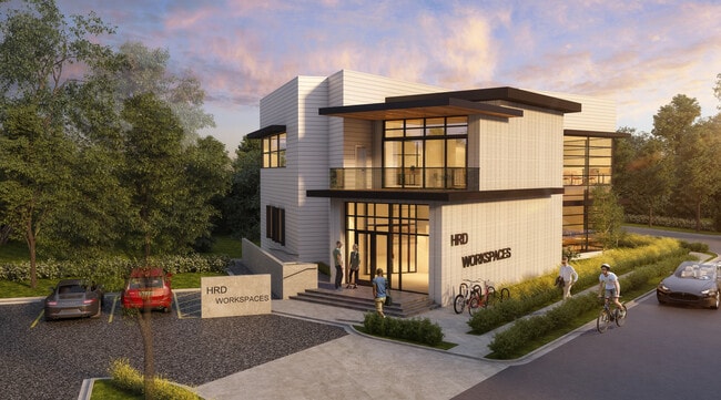
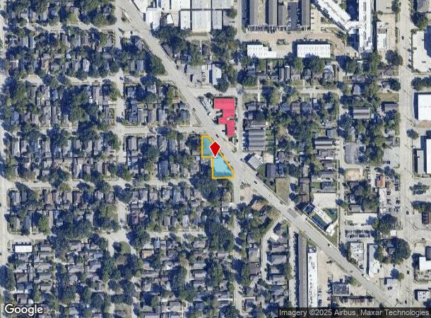
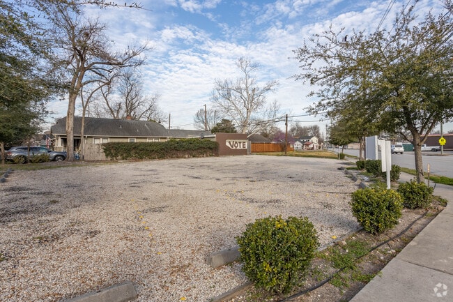
Property Record
4901 N Main St, Houston, TX 77009
Current Lease Availabilities
NEARBY LISTINGS FOR SALE OR LEASE
Property Detail
4901 N Main St
Houston-The Woodlands-Sugar Land, TX
North Norhill 3Rd Par R/P
0620880000017
RES A BLK 1 NORTH NORHILL 3RD PAR R/P
Commercialnec
Harris
X
Texas
48201C0670M
17
2024
0.33 AC
2025
North Loop West
210500
Houston
1,348 SF
DEMOGRAPHICS near 4901 N Main St
1 Mile
3 Mile
5 Mile
2024 Total Population
21,248
182,626
445,458
2029 Population
22,062
189,932
463,234
Pop Growth 2024-2029
+ 3.83%
+ 4.00%
+ 3.99%
Average Age
39
37
37
2024 Total Households
9,539
78,911
192,730
HH Growth 2024-2029
+ 3.67%
+ 4.31%
+ 4.25%
Median Household Inc
$114,058
$90,333
$74,148
Avg Household Size
2.20
2.20
2.20
2024 Avg HH Vehicles
2.00
2.00
2.00
Median Home Value
$624,603
$429,989
$392,898
Median Year Built
1952
1998
1990
Nearby Places
Map Layers
Map Styles
 Street
 Aerial
- Restaurants
- Banks
- Shops
- Fitness
- Groceries
PUBLIC TRANSPORTATION
COMMUTER RAIL
DRIVE
WALK
Distance
6 min
2.9 mi
AIRPORT
William P Hobby
DRIVE
WALK
Distance
William P Hobby
27 min
15.8 mi
George Bush Intcntl/Houston
DRIVE
WALK
Distance
George Bush Intcntl/Houston
24 min
18.7 mi
Freight Ports
Port of Houston
DRIVE
WALK
Distance
Port of Houston
21 min
12.5 mi
Nearby Properties
Address
Land Use
TOTAL SIZE
Lot Size
Zoning
Address
Land Use
TOTAL SIZE
Lot Size
Zoning
1,383,720 SF
1.47 AC
Address
Land Use
TOTAL SIZE
Lot Size
Zoning
1,916,394 SF
1.46 AC
Address
Land Use
TOTAL SIZE
Lot Size
Zoning
1,436,400 SF
1.44 AC
Address
Land Use
TOTAL SIZE
Lot Size
Zoning
1,321,033 SF
1.46 AC
Address
Land Use
TOTAL SIZE
Lot Size
Zoning
4,169,721 SF
31.23 AC
Address
Land Use
TOTAL SIZE
Lot Size
Zoning
2,005,097 SF
1.44 AC
Address
Land Use
TOTAL SIZE
Lot Size
Zoning
1,657,484 SF
1.44 AC
Address
Land Use
TOTAL SIZE
Lot Size
Zoning
555,351 SF
1.40 AC
Address
Land Use
TOTAL SIZE
Lot Size
Zoning
934,258 SF
1.45 AC
Address
Land Use
TOTAL SIZE
Lot Size
Zoning
1,182,525 SF
1.11 AC
Address
Land Use
TOTAL SIZE
Lot Size
Zoning
608,233 SF
2.23 AC
Address
Land Use
TOTAL SIZE
Lot Size
Zoning
468,513 SF
0.86 AC
Address
Land Use
TOTAL SIZE
Lot Size
Zoning
265,878 SF
2.23 AC
Address
Land Use
TOTAL SIZE
Lot Size
Zoning
453,456 SF
3.11 AC
Address
Land Use
TOTAL SIZE
Lot Size
Zoning
596,700 SF
0.82 AC
Address
Land Use
TOTAL SIZE
Lot Size
Zoning
709,825 SF
4.92 AC
Address
Land Use
TOTAL SIZE
Lot Size
Zoning
360,043 SF
0.81 AC
Address
Land Use
TOTAL SIZE
Lot Size
Zoning
649,000 SF
7.35 AC
Address
Land Use
TOTAL SIZE
Lot Size
Zoning
535,500 SF
15.97 AC
Address
Land Use
TOTAL SIZE
Lot Size
Zoning
519,374 SF
6.18 AC
Address
Land Use
TOTAL SIZE
Lot Size
Zoning
788,433 SF
5.09 AC
Address
Land Use
TOTAL SIZE
Lot Size
Zoning
616,707 SF
5.74 AC
Address
Land Use
TOTAL SIZE
Lot Size
Zoning
675,412 SF
10.09 AC
Address
Land Use
TOTAL SIZE
Lot Size
Zoning
641,392 SF
10 AC
Address
Land Use
TOTAL SIZE
Lot Size
Zoning
563,626 SF
4.71 AC
Address
Land Use
TOTAL SIZE
Lot Size
Zoning
308,055 SF
2.22 AC
Address
Land Use
TOTAL SIZE
Lot Size
Zoning
474,326 SF
43.16 AC
Address
Land Use
TOTAL SIZE
Lot Size
Zoning
314,489 SF
1.84 AC
Address
Land Use
TOTAL SIZE
Lot Size
Zoning
429,771 SF
3.49 AC
Address
Land Use
TOTAL SIZE
Lot Size
Zoning
315,439 SF
3.54 AC
The World's #1 Commercial Real Estate Marketplace
Connect with us
© 2025 CoStar Group
The information above has been obtained from sources believed reliable. While we do not doubt its accuracy we have not verified it and make no guarantee, warranty or representation about it. It is your responsibility to independently confirm its accuracy and completeness. Any projections, opinions, assumptions, or estimates used are for example only and do not represent the current or future performance of the property. The value of this transaction to you depends on tax and other factors which should be evaluated by your tax, financial, and legal advisors. You and your advisors should conduct a careful, independent investigation of the property to determine to your satisfaction the suitability of the property for your needs.