Property Record
4901 N Whitaker Rd, Amarillo, TX 79108
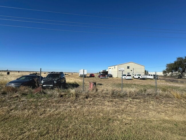

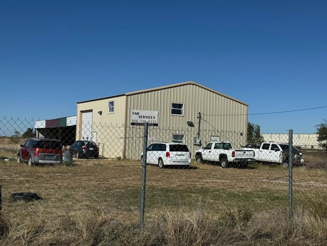
This Property Is For Sale
Property Detail
4901 N Whitaker Rd
R-200-1020-4500-0
SECT 102 A B & M BLK 0002, 459.09FT S X 1110.6FT W BEG 2184.72FT S & 30FT W OF NE COR OF SECT, 11.7100 ACRES
Utilities
POTTER
B and X Area of moderate flood hazard, usually the area between the limits of the 100-year and 500-year floods.
Texas
2024
11.71 AC
2025
Amarillo
014100
Other Market Areas
2,000 SF
Amarillo, TX
NEARBY LISTINGS FOR SALE OR LEASE
-
-
View all Amarillo listings for sale on LoopNet.com
DEMOGRAPHICS near 4901 N Whitaker Rd
1 mile
3 mile
5 mile
2024 Total Population
127
18,236
47,861
2029 Population
128
17,889
47,248
Pop Growth 2024-2029
+ 0.79%
(1.90%)
(1.28%)
Average Age
34
37
37
2024 Total Households
43
4,326
14,491
HH Growth 2024-2029
0.00%
(2.45%)
(1.43%)
Median Household Inc
$55,000
$44,405
$44,038
Avg Household Size
3.00
3.10
2.90
2024 Avg HH Vehicles
2.00
2.00
2.00
Median Home Value
$79,411
$108,848
$112,743
Median Year Built
1987
1965
1959
Nearby Places
Map Layers
Map Styles
 Street
 Aerial
Transit
 Traffic
 Biking
Places
Listings with unknown addresses are not visible on the map
- Restaurants
- Banks
- Shops
- Fitness
- Groceries
PUBLIC TRANSPORTATION
AIRPORT
Rick Husband Amarillo International
Drive
Walk
Distance
Rick Husband Amarillo International
14 min
9.4 mi
Freight Ports
Tulsa Port Of Catoosa
Drive
Walk
Distance
Tulsa Port Of Catoosa
396 min
376.1 mi
Nearby Properties
Address
Land Use
TOTAL SIZE
Lot Size
Zoning
Address
Land Use
TOTAL SIZE
Lot Size
Zoning
1,079,953 SF
106.07 AC
Address
Land Use
TOTAL SIZE
Lot Size
Zoning
265,956 SF
48 AC
Address
Land Use
TOTAL SIZE
Lot Size
Zoning
91,802 SF
7 AC
Address
Land Use
TOTAL SIZE
Lot Size
Zoning
315,634 SF
53.49 AC
Address
Land Use
TOTAL SIZE
Lot Size
Zoning
76,777 SF
17.10 AC
Address
Land Use
TOTAL SIZE
Lot Size
Zoning
64,847 SF
25.67 AC
R1
Address
Land Use
TOTAL SIZE
Lot Size
Zoning
39,430 SF
38.42 AC
Address
Land Use
TOTAL SIZE
Lot Size
Zoning
92,341 SF
9.91 AC
R3
Address
Land Use
TOTAL SIZE
Lot Size
Zoning
23.39 AC
Address
Land Use
TOTAL SIZE
Lot Size
Zoning
37,134 SF
3.26 AC
Address
Land Use
TOTAL SIZE
Lot Size
Zoning
73,258 SF
7.58 AC
R2
Address
Land Use
TOTAL SIZE
Lot Size
Zoning
79,521 SF
Address
Land Use
TOTAL SIZE
Lot Size
Zoning
Address
Land Use
TOTAL SIZE
Lot Size
Zoning
Address
Land Use
TOTAL SIZE
Lot Size
Zoning
89,982 SF
9.75 AC
Address
Land Use
TOTAL SIZE
Lot Size
Zoning
58,977 SF
25.27 AC
PD
Address
Land Use
TOTAL SIZE
Lot Size
Zoning
65,730 SF
9.09 AC
A
Address
Land Use
TOTAL SIZE
Lot Size
Zoning
64,496 SF
8.85 AC
Address
Land Use
TOTAL SIZE
Lot Size
Zoning
201,990 SF
23.17 AC
MF1
Address
Land Use
TOTAL SIZE
Lot Size
Zoning
122,298 SF
8 AC
MF1
Address
Land Use
TOTAL SIZE
Lot Size
Zoning
64,408 SF
Address
Land Use
TOTAL SIZE
Lot Size
Zoning
50,000 SF
16.68 AC
Address
Land Use
TOTAL SIZE
Lot Size
Zoning
138,823 SF
13.74 AC
MF1
Address
Land Use
TOTAL SIZE
Lot Size
Zoning
25,168 SF
4.30 AC
Address
Land Use
TOTAL SIZE
Lot Size
Zoning
417,945 SF
24.94 AC
I1
Address
Land Use
TOTAL SIZE
Lot Size
Zoning
82,202 SF
24.18 AC
1F3S
Address
Land Use
TOTAL SIZE
Lot Size
Zoning
50,000 SF
5.59 AC
Address
Land Use
TOTAL SIZE
Lot Size
Zoning
191,071 SF
20.46 AC
I1
Address
Land Use
TOTAL SIZE
Lot Size
Zoning
32,000 SF
47.19 AC
Address
Land Use
TOTAL SIZE
Lot Size
Zoning
167,625 SF
20.12 AC
The World's #1 Commercial Real Estate Marketplace
Connect with us
© 2026 CoStar Group
The information above has been obtained from sources believed reliable. While we do not doubt its accuracy we have not verified it and make no guarantee, warranty or representation about it. It is your responsibility to independently confirm its accuracy and completeness. Any projections, opinions, assumptions, or estimates used are for example only and do not represent the current or future performance of the property. The value of this transaction to you depends on tax and other factors which should be evaluated by your tax, financial, and legal advisors. You and your advisors should conduct a careful, independent investigation of the property to determine to your satisfaction the suitability of the property for your needs.