Property Record
4901 Shalimar Ln, Davie, FL 33328
NEARBY LISTINGS FOR SALE OR LEASE
Property Detail
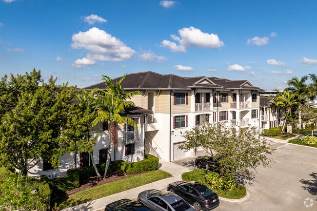
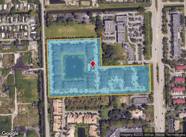
4901 Shalimar Ln
50-41-33-44-0010
Shalimar @ Davie 181-108 B
Multifamilydwelling
SHALIMAR @ DAVIE 181-108 B PARCEL A
AE
Broward
12011C0545J
Florida
2024
13.64 AC
2025
Outer Weston/Davie
070602
South Florida
292,581 SF
Fort Lauderdale-Pompano Beach-Deerfield Beach, FL
DEMOGRAPHICS near 4901 Shalimar Ln
1 Mile
3 Mile
5 Mile
2024 Total Population
9,565
110,871
324,139
2029 Population
9,375
109,137
320,077
Pop Growth 2024-2029
(1.99%)
(1.56%)
(1.25%)
Average Age
38
39
40
2024 Total Households
3,372
39,837
116,508
HH Growth 2024-2029
(2.70%)
(2.11%)
(1.69%)
Median Household Inc
$100,344
$79,795
$74,999
Avg Household Size
2.70
2.60
2.70
2024 Avg HH Vehicles
2.00
2.00
2.00
Median Home Value
$437,659
$368,941
$363,832
Median Year Built
1986
1982
1981
Nearby Places
Map Layers
Map Styles
 Street
 Aerial
- Restaurants
- Banks
- Shops
- Fitness
- Groceries
PUBLIC TRANSPORTATION
COMMUTER RAIL
Fort Lauderdale/Hollywood International Airport (Mangonia Park - Miami Airport - Tri-Rail, Tri-County Commuter - Tri-Rail, West Palm Beach - MiamiCentral - Tri-Rail)
DRIVE
WALK
Distance
Fort Lauderdale/Hollywood International Airport (Mangonia Park - Miami Airport - Tri-Rail, Tri-County Commuter - Tri-Rail, West Palm Beach - MiamiCentral - Tri-Rail)
13 min
6.5 mi
Sheridan Street (Tri-County Commuter - South Florida Regional Transportation Authority (Tri-Rail))
DRIVE
WALK
Distance
Sheridan Street (Tri-County Commuter - South Florida Regional Transportation Authority (Tri-Rail))
16 min
7.6 mi
AIRPORT
Fort Lauderdale/Hollywood International
DRIVE
WALK
Distance
Fort Lauderdale/Hollywood International
15 min
7.4 mi
Miami International
DRIVE
WALK
Distance
Miami International
42 min
27.6 mi
Freight Ports
Port Everglades
DRIVE
WALK
Distance
Port Everglades
18 min
10.2 mi
Nearby Properties
Address
Land Use
TOTAL SIZE
Lot Size
Zoning
Address
Land Use
TOTAL SIZE
Lot Size
Zoning
4,212,940 SF
69.36 AC
N/A
Address
Land Use
TOTAL SIZE
Lot Size
Zoning
4,069,966 SF
161.58 AC
RAC-AV
Address
Land Use
TOTAL SIZE
Lot Size
Zoning
589,748 SF
27.34 AC
RAC-RTE
Address
Land Use
TOTAL SIZE
Lot Size
Zoning
1,357,572 SF
126.23 AC
RAC-ED
Address
Land Use
TOTAL SIZE
Lot Size
Zoning
550,907 SF
26.92 AC
RAC-RTE
Address
Land Use
TOTAL SIZE
Lot Size
Zoning
475,897 SF
14.91 AC
RAC-RTE
Address
Land Use
TOTAL SIZE
Lot Size
Zoning
413,123 SF
63.50 AC
B-3
Address
Land Use
TOTAL SIZE
Lot Size
Zoning
438,123 SF
47.44 AC
RM-22
Address
Land Use
TOTAL SIZE
Lot Size
Zoning
409,340 SF
15.49 AC
RAC-RTE
Address
Land Use
TOTAL SIZE
Lot Size
Zoning
635,706 SF
9.58 AC
GRIFFIN CO
Address
Land Use
TOTAL SIZE
Lot Size
Zoning
456,384 SF
81.33 AC
RAC-ED
Address
Land Use
TOTAL SIZE
Lot Size
Zoning
471,109 SF
5.57 AC
M-PM
Address
Land Use
TOTAL SIZE
Lot Size
Zoning
576,167 SF
27 AC
RAC-RTE
Address
Land Use
TOTAL SIZE
Lot Size
Zoning
334,723 SF
7.47 AC
RAC-AV
Address
Land Use
TOTAL SIZE
Lot Size
Zoning
350,663 SF
16.86 AC
RAC-RTE
Address
Land Use
TOTAL SIZE
Lot Size
Zoning
356,053 SF
8.12 AC
RAC-RTE
Address
Land Use
TOTAL SIZE
Lot Size
Zoning
326,240 SF
45.28 AC
N/A
Address
Land Use
TOTAL SIZE
Lot Size
Zoning
385,242 SF
66.40 AC
N/A
Address
Land Use
TOTAL SIZE
Lot Size
Zoning
284,895 SF
16.45 AC
(R-MF)
Address
Land Use
TOTAL SIZE
Lot Size
Zoning
505,730 SF
18.07 AC
RAC-AV
Address
Land Use
TOTAL SIZE
Lot Size
Zoning
281,510 SF
11.39 AC
PMUD
Address
Land Use
TOTAL SIZE
Lot Size
Zoning
222,024 SF
13.64 AC
RM-16
Address
Land Use
TOTAL SIZE
Lot Size
Zoning
256,480 SF
9.85 AC
(R-MF)
Address
Land Use
TOTAL SIZE
Lot Size
Zoning
302,410 SF
35.11 AC
X-1
Address
Land Use
TOTAL SIZE
Lot Size
Zoning
337,994 SF
3.03 AC
RAC-ND4
Address
Land Use
TOTAL SIZE
Lot Size
Zoning
237,370 SF
12.51 AC
RM-16
Address
Land Use
TOTAL SIZE
Lot Size
Zoning
236,654 SF
14.10 AC
RM-16
Address
Land Use
TOTAL SIZE
Lot Size
Zoning
210,856 SF
5.93 AC
B-7Q
Address
Land Use
TOTAL SIZE
Lot Size
Zoning
247,577 SF
39.47 AC
RAC-ED
The World's #1 Commercial Real Estate Marketplace
Connect with us
© 2025 CoStar Group
The information above has been obtained from sources believed reliable. While we do not doubt its accuracy we have not verified it and make no guarantee, warranty or representation about it. It is your responsibility to independently confirm its accuracy and completeness. Any projections, opinions, assumptions, or estimates used are for example only and do not represent the current or future performance of the property. The value of this transaction to you depends on tax and other factors which should be evaluated by your tax, financial, and legal advisors. You and your advisors should conduct a careful, independent investigation of the property to determine to your satisfaction the suitability of the property for your needs.