Property Record
4901 Urbana Rd, Springfield, OH 45502


NEARBY LISTINGS FOR SALE OR LEASE
-
-
View all Springfield listings for sale on LoopNet.com
Property Detail
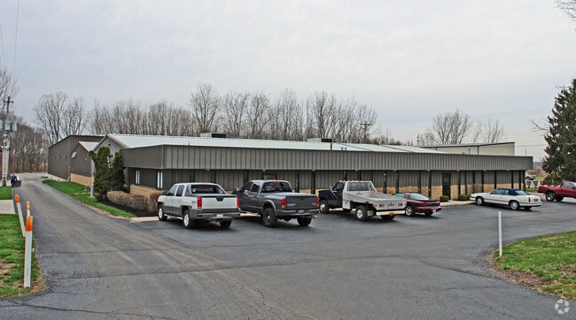
4901 Urbana Rd
Springfield, OH
Mrs
22-00300-03300-0051
PT N W QR
Lightindustrial
Clark
A
Ohio
39023C0185E
51
2024
4.24 AC
2025
Northeast Dayton
002605
Cincinnati/Dayton
33,808 SF
DEMOGRAPHICS near 4901 Urbana Rd
1 Mile
3 Mile
5 Mile
2024 Total Population
609
19,999
50,174
2029 Population
593
19,634
49,684
Pop Growth 2024-2029
(2.63%)
(1.83%)
(0.98%)
Average Age
43
47
42
2024 Total Households
235
9,210
21,219
HH Growth 2024-2029
(2.55%)
(1.85%)
(1.03%)
Median Household Inc
$114,374
$61,104
$58,054
Avg Household Size
2.60
2.10
2.20
2024 Avg HH Vehicles
2.00
2.00
2.00
Median Home Value
$256,961
$161,595
$153,562
Median Year Built
1994
1975
1967
Nearby Places
Map Layers
Map Styles
 Street
 Aerial
- Restaurants
- Banks
- Shops
- Fitness
- Groceries
PUBLIC TRANSPORTATION
AIRPORT
James M Cox Dayton International
DRIVE
WALK
Distance
James M Cox Dayton International
38 min
30.1 mi
SALE & LEASE HISTORY
LISTING DATE
SALE/LEASE

Sep 22, 2022
For Sale
Nearby Properties
Address
Land Use
TOTAL SIZE
Lot Size
Zoning
Address
Land Use
TOTAL SIZE
Lot Size
Zoning
3,360 SF
96.84 AC
Address
Land Use
TOTAL SIZE
Lot Size
Zoning
193,701 SF
16.31 AC
Address
Land Use
TOTAL SIZE
Lot Size
Zoning
61,376 SF
3.95 AC
Address
Land Use
TOTAL SIZE
Lot Size
Zoning
1,582 SF
42.13 AC
Address
Land Use
TOTAL SIZE
Lot Size
Zoning
1,667,526 SF
104.07 AC
I-1
Address
Land Use
TOTAL SIZE
Lot Size
Zoning
48,514 SF
9.72 AC
R-4S
Address
Land Use
TOTAL SIZE
Lot Size
Zoning
62,085 SF
6.05 AC
A-1
Address
Land Use
TOTAL SIZE
Lot Size
Zoning
79,187 SF
7.70 AC
Address
Land Use
TOTAL SIZE
Lot Size
Zoning
36,172 SF
2.14 AC
Address
Land Use
TOTAL SIZE
Lot Size
Zoning
12.76 AC
Address
Land Use
TOTAL SIZE
Lot Size
Zoning
28,228 SF
7.47 AC
A-1
Address
Land Use
TOTAL SIZE
Lot Size
Zoning
41,710 SF
5.25 AC
Address
Land Use
TOTAL SIZE
Lot Size
Zoning
521,780 SF
206.66 AC
I-1
Address
Land Use
TOTAL SIZE
Lot Size
Zoning
257,774 SF
7.39 AC
M-2
Address
Land Use
TOTAL SIZE
Lot Size
Zoning
16,860 SF
18.13 AC
Address
Land Use
TOTAL SIZE
Lot Size
Zoning
6,636 SF
5.53 AC
Address
Land Use
TOTAL SIZE
Lot Size
Zoning
Address
Land Use
TOTAL SIZE
Lot Size
Zoning
65,174 SF
4.06 AC
Address
Land Use
TOTAL SIZE
Lot Size
Zoning
191,825 SF
9.23 AC
Address
Land Use
TOTAL SIZE
Lot Size
Zoning
96,300 SF
11.57 AC
Address
Land Use
TOTAL SIZE
Lot Size
Zoning
60,518 SF
5.18 AC
Address
Land Use
TOTAL SIZE
Lot Size
Zoning
25,824 SF
3.32 AC
Address
Land Use
TOTAL SIZE
Lot Size
Zoning
14,900 SF
5.91 AC
Address
Land Use
TOTAL SIZE
Lot Size
Zoning
120,870 SF
16.37 AC
Address
Land Use
TOTAL SIZE
Lot Size
Zoning
41,450 SF
4.50 AC
Address
Land Use
TOTAL SIZE
Lot Size
Zoning
64,600 SF
15.08 AC
I-1
Address
Land Use
TOTAL SIZE
Lot Size
Zoning
66,354 SF
5.36 AC
Address
Land Use
TOTAL SIZE
Lot Size
Zoning
25,378 SF
3.56 AC
Address
Land Use
TOTAL SIZE
Lot Size
Zoning
64,791 SF
3.79 AC
Address
Land Use
TOTAL SIZE
Lot Size
Zoning
42,208 SF
3.47 AC
The World's #1 Commercial Real Estate Marketplace
Connect with us
© 2025 CoStar Group
The information above has been obtained from sources believed reliable. While we do not doubt its accuracy we have not verified it and make no guarantee, warranty or representation about it. It is your responsibility to independently confirm its accuracy and completeness. Any projections, opinions, assumptions, or estimates used are for example only and do not represent the current or future performance of the property. The value of this transaction to you depends on tax and other factors which should be evaluated by your tax, financial, and legal advisors. You and your advisors should conduct a careful, independent investigation of the property to determine to your satisfaction the suitability of the property for your needs.