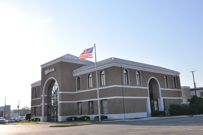
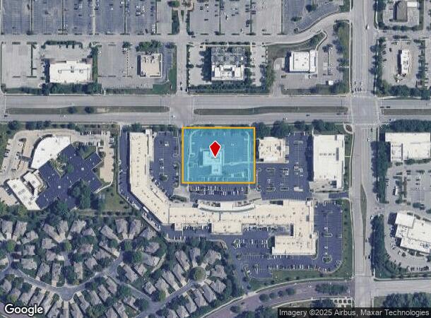
Property Record
4901 W 119Th St, Leawood, KS 66209
NEARBY LISTINGS FOR SALE OR LEASE
Property Detail
4901 W 119Th St
Kansas City, MO-KS
Hawthorne Valley Plaza Replat
NP29950000-0002
HAWTHORNE VALLEY PLAZA REPLAT LT 2 OPC 473 1G A 2
Officebuilding
Johnson
X
Kansas
20091C0069G
2
2024
1.68 AC
2024
South Johnson County
053202
Kansas City
9,256 SF
DEMOGRAPHICS near 4901 W 119Th St
1 Mile
3 Mile
5 Mile
2024 Total Population
8,098
79,330
210,968
2029 Population
8,488
82,316
218,302
Pop Growth 2024-2029
+ 4.82%
+ 3.76%
+ 3.48%
Average Age
49
44
42
2024 Total Households
3,810
35,223
89,728
HH Growth 2024-2029
+ 4.96%
+ 4.03%
+ 3.57%
Median Household Inc
$117,762
$97,316
$95,384
Avg Household Size
2.00
2.20
2.30
2024 Avg HH Vehicles
2.00
2.00
2.00
Median Home Value
$474,196
$397,650
$365,921
Median Year Built
1990
1988
1985
Nearby Places
Map Layers
Map Styles
 Street
 Aerial
- Restaurants
- Banks
- Shops
- Fitness
- Groceries
PUBLIC TRANSPORTATION
AIRPORT
Kansas City International
DRIVE
WALK
Distance
Kansas City International
49 min
37.3 mi
SALE & LEASE HISTORY
LISTING DATE
SALE/LEASE

Jan 30, 2020
For Lease
Jan 17, 2025
For Lease
Feb 20, 2019
For Lease
Feb 01, 2017
For Lease
Nearby Properties
Address
Land Use
TOTAL SIZE
Lot Size
Zoning
Address
Land Use
TOTAL SIZE
Lot Size
Zoning
1,173,824 SF
63.09 AC
R-1
Address
Land Use
TOTAL SIZE
Lot Size
Zoning
364,818 SF
25.48 AC
R-1
Address
Land Use
TOTAL SIZE
Lot Size
Zoning
384,819 SF
67.59 AC
AG
Address
Land Use
TOTAL SIZE
Lot Size
Zoning
47.39 AC
AG
Address
Land Use
TOTAL SIZE
Lot Size
Zoning
177,588 SF
9.27 AC
CP-O
Address
Land Use
TOTAL SIZE
Lot Size
Zoning
189,882 SF
13.04 AC
CP-O
Address
Land Use
TOTAL SIZE
Lot Size
Zoning
316,432 SF
29.39 AC
R-1
Address
Land Use
TOTAL SIZE
Lot Size
Zoning
3,426,762 SF
183.73 AC
CP-O
Address
Land Use
TOTAL SIZE
Lot Size
Zoning
122,309 SF
76.14 AC
R-1
Address
Land Use
TOTAL SIZE
Lot Size
Zoning
305,147 SF
49.02 AC
R-1
Address
Land Use
TOTAL SIZE
Lot Size
Zoning
335,643 SF
25.13 AC
R-1
Address
Land Use
TOTAL SIZE
Lot Size
Zoning
184,524 SF
33.20 AC
AG
Address
Land Use
TOTAL SIZE
Lot Size
Zoning
325,588 SF
36.63 AC
SD-CR
Address
Land Use
TOTAL SIZE
Lot Size
Zoning
173,314 SF
25.83 AC
R-1
Address
Land Use
TOTAL SIZE
Lot Size
Zoning
79,917 SF
7.86 AC
SD-NCR
Address
Land Use
TOTAL SIZE
Lot Size
Zoning
120,305 SF
7.01 AC
CP-O
Address
Land Use
TOTAL SIZE
Lot Size
Zoning
259,257 SF
24.74 AC
CP-O
Address
Land Use
TOTAL SIZE
Lot Size
Zoning
96,100 SF
25.01 AC
R-1
Address
Land Use
TOTAL SIZE
Lot Size
Zoning
102,411 SF
17.02 AC
AG
Address
Land Use
TOTAL SIZE
Lot Size
Zoning
110,710 SF
4.66 AC
CP-O
Address
Land Use
TOTAL SIZE
Lot Size
Zoning
59,570 SF
8.46 AC
SD-O
Address
Land Use
TOTAL SIZE
Lot Size
Zoning
113,263 SF
3.53 AC
CP-O
Address
Land Use
TOTAL SIZE
Lot Size
Zoning
73,383 SF
9.53 AC
R-1
Address
Land Use
TOTAL SIZE
Lot Size
Zoning
166,097 SF
37.29 AC
R-1
Address
Land Use
TOTAL SIZE
Lot Size
Zoning
105,110 SF
8.93 AC
AG
Address
Land Use
TOTAL SIZE
Lot Size
Zoning
436,499 SF
22.71 AC
Address
Land Use
TOTAL SIZE
Lot Size
Zoning
179,965 SF
6.15 AC
CP-O
Address
Land Use
TOTAL SIZE
Lot Size
Zoning
863,831 SF
31.21 AC
BP
Address
Land Use
TOTAL SIZE
Lot Size
Zoning
119,320 SF
19.74 AC
R-1
Address
Land Use
TOTAL SIZE
Lot Size
Zoning
66,083 SF
14.91 AC
R-1
The World's #1 Commercial Real Estate Marketplace
Connect with us
© 2025 CoStar Group
The information above has been obtained from sources believed reliable. While we do not doubt its accuracy we have not verified it and make no guarantee, warranty or representation about it. It is your responsibility to independently confirm its accuracy and completeness. Any projections, opinions, assumptions, or estimates used are for example only and do not represent the current or future performance of the property. The value of this transaction to you depends on tax and other factors which should be evaluated by your tax, financial, and legal advisors. You and your advisors should conduct a careful, independent investigation of the property to determine to your satisfaction the suitability of the property for your needs.