Property Record
4901 Walzem Rd, Windcrest, TX 78218


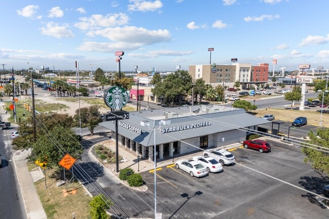

Property Detail
4901 Walzem Rd
San Antonio-New Braunfels, TX
CB 5474A BLK 116 LOT 3
05474-116-0030
BEXAR
Restaurantdrivein
Texas
AE The base floodplain where base flood elevations are provided. AE Zones are now used on new format FIRMs instead of A1-A30 Zones.
3
2024
0.65 AC
2025
Northeast
121300
San Antonio
2,741 SF
NEARBY LISTINGS FOR SALE OR LEASE
DEMOGRAPHICS near 4901 Walzem Rd
1 mile
3 mile
5 mile
2025 Total Population
9,630
104,427
286,812
2030 Population
10,019
109,511
300,995
Pop Growth 2025-2030
+ 4.04%
+ 4.87%
+ 4.95%
Average Age
38
38
38
2025 Total Households
3,740
40,653
107,636
HH Growth 2025-2030
+ 4.12%
+ 4.97%
+ 5.06%
Median Household Inc
$59,466
$60,034
$70,269
Avg Household Size
2.50
2.50
2.60
2025 Avg HH Vehicles
2.00
2.00
2.00
Median Home Value
$216,279
$227,411
$244,398
Median Year Built
1971
1978
1983
Nearby Places
Map Layers
Map Styles
 Street
 Aerial
Layers
 Traffic
 Biking
Places
Listings with unknown addresses are not visible on the map
- Restaurants
- Banks
- Shops
- Fitness
- Groceries
PUBLIC TRANSPORTATION
COMMUTER RAIL
San Antonio Amtrak Station (Sunset Limited - Amtrak, Texas Eagle - Amtrak)
Drive
Walk
Distance
San Antonio Amtrak Station (Sunset Limited - Amtrak, Texas Eagle - Amtrak)
14 min
9.8 mi
AIRPORT
San Antonio International
Drive
Walk
Distance
San Antonio International
9 min
5.8 mi
Freight Ports
Calhoun Port
Drive
Walk
Distance
Calhoun Port
179 min
147.7 mi
SALE & LEASE HISTORY
LISTING DATE
SALE/LEASE

Oct 10, 2024
For Sale
Nearby Properties
Address
Land Use
TOTAL SIZE
Lot Size
Zoning
Address
Land Use
TOTAL SIZE
Lot Size
Zoning
1,649,488 SF
70 AC
Address
Land Use
TOTAL SIZE
Lot Size
Zoning
25,513 SF
18.14 AC
Address
Land Use
TOTAL SIZE
Lot Size
Zoning
359,349 SF
23.59 AC
Address
Land Use
TOTAL SIZE
Lot Size
Zoning
239,264 SF
9.02 AC
Address
Land Use
TOTAL SIZE
Lot Size
Zoning
266,702 SF
13.49 AC
Address
Land Use
TOTAL SIZE
Lot Size
Zoning
288,350 SF
13.01 AC
Address
Land Use
TOTAL SIZE
Lot Size
Zoning
110,605 SF
19.95 AC
Address
Land Use
TOTAL SIZE
Lot Size
Zoning
157,762 SF
9.26 AC
Address
Land Use
TOTAL SIZE
Lot Size
Zoning
598,070 SF
46.05 AC
Address
Land Use
TOTAL SIZE
Lot Size
Zoning
328,605 SF
25.69 AC
Address
Land Use
TOTAL SIZE
Lot Size
Zoning
457,302 SF
34.40 AC
Address
Land Use
TOTAL SIZE
Lot Size
Zoning
279,012 SF
12.17 AC
Address
Land Use
TOTAL SIZE
Lot Size
Zoning
180,000 SF
40.73 AC
Address
Land Use
TOTAL SIZE
Lot Size
Zoning
273,516 SF
17.50 AC
Address
Land Use
TOTAL SIZE
Lot Size
Zoning
132.44 AC
Address
Land Use
TOTAL SIZE
Lot Size
Zoning
92,859 SF
11.95 AC
Address
Land Use
TOTAL SIZE
Lot Size
Zoning
265,015 SF
12.81 AC
Address
Land Use
TOTAL SIZE
Lot Size
Zoning
337,468 SF
21.84 AC
Address
Land Use
TOTAL SIZE
Lot Size
Zoning
205,862 SF
10.79 AC
Address
Land Use
TOTAL SIZE
Lot Size
Zoning
275,327 SF
13.52 AC
Address
Land Use
TOTAL SIZE
Lot Size
Zoning
373,134 SF
16.29 AC
Address
Land Use
TOTAL SIZE
Lot Size
Zoning
222,865 SF
17.75 AC
Address
Land Use
TOTAL SIZE
Lot Size
Zoning
431,326 SF
42.70 AC
Address
Land Use
TOTAL SIZE
Lot Size
Zoning
106,139 SF
5.84 AC
Address
Land Use
TOTAL SIZE
Lot Size
Zoning
257,263 SF
10.07 AC
Address
Land Use
TOTAL SIZE
Lot Size
Zoning
437,807 SF
24.55 AC
Address
Land Use
TOTAL SIZE
Lot Size
Zoning
391,863 SF
24.43 AC
Address
Land Use
TOTAL SIZE
Lot Size
Zoning
15.42 AC
Address
Land Use
TOTAL SIZE
Lot Size
Zoning
257,734 SF
5.57 AC
Address
Land Use
TOTAL SIZE
Lot Size
Zoning
324,905 SF
22.32 AC
The World's #1 Commercial Real Estate Marketplace
Connect with us
© 2026 CoStar Group
The information above has been obtained from sources believed reliable. While we do not doubt its accuracy we have not verified it and make no guarantee, warranty or representation about it. It is your responsibility to independently confirm its accuracy and completeness. Any projections, opinions, assumptions, or estimates used are for example only and do not represent the current or future performance of the property. The value of this transaction to you depends on tax and other factors which should be evaluated by your tax, financial, and legal advisors. You and your advisors should conduct a careful, independent investigation of the property to determine to your satisfaction the suitability of the property for your needs.