Property Record
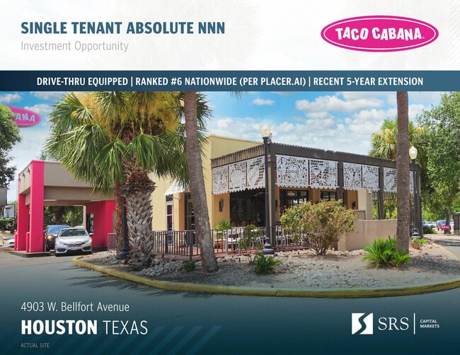
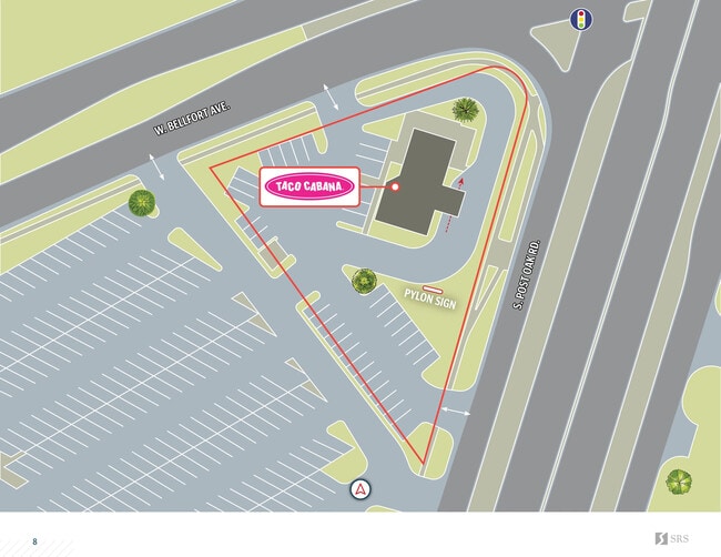
4903 W Bellfort Ave, Houston, TX 77035

This Property Is For Sale
NEARBY LISTINGS FOR SALE OR LEASE
Property Detail
4903 W Bellfort Ave
1182370010004
Meyerland Center
Restaurantdrivein
RES A3 BLK 1 MEYERLAND CENTER
AE
Harris
48201C0865M
Texas
2024
0.86 AC
2025
Southwest
420600
Houston
2,926 SF
Houston-The Woodlands-Sugar Land, TX
DEMOGRAPHICS near 4903 W Bellfort Ave
1 Mile
3 Mile
5 Mile
2024 Total Population
13,471
159,884
465,209
2029 Population
13,841
163,939
479,116
Pop Growth 2024-2029
+ 2.75%
+ 2.54%
+ 2.99%
Average Age
39
37
36
2024 Total Households
5,364
60,269
182,903
HH Growth 2024-2029
+ 2.65%
+ 2.54%
+ 3.00%
Median Household Inc
$110,907
$63,383
$57,519
Avg Household Size
2.50
2.60
2.50
2024 Avg HH Vehicles
2.00
2.00
2.00
Median Home Value
$406,679
$363,724
$284,904
Median Year Built
1962
1976
1981
Nearby Places
Map Layers
Map Styles
 Street
 Aerial
- Restaurants
- Banks
- Shops
- Fitness
- Groceries
PUBLIC TRANSPORTATION
AIRPORT
William P Hobby
DRIVE
WALK
Distance
William P Hobby
28 min
16.0 mi
George Bush Intcntl/Houston
DRIVE
WALK
Distance
George Bush Intcntl/Houston
39 min
30.7 mi
Freight Ports
Port of Houston
DRIVE
WALK
Distance
Port of Houston
25 min
15.9 mi
Nearby Properties
Address
Land Use
TOTAL SIZE
Lot Size
Zoning
Address
Land Use
TOTAL SIZE
Lot Size
Zoning
777,791 SF
47.90 AC
Address
Land Use
TOTAL SIZE
Lot Size
Zoning
507,499 SF
7.66 AC
Address
Land Use
TOTAL SIZE
Lot Size
Zoning
1,202,191 SF
39.08 AC
Address
Land Use
TOTAL SIZE
Lot Size
Zoning
15.46 AC
Address
Land Use
TOTAL SIZE
Lot Size
Zoning
550,115 SF
6.38 AC
Address
Land Use
TOTAL SIZE
Lot Size
Zoning
284,836 SF
4.22 AC
Address
Land Use
TOTAL SIZE
Lot Size
Zoning
335,626 SF
4.22 AC
Address
Land Use
TOTAL SIZE
Lot Size
Zoning
544,698 SF
15.66 AC
Address
Land Use
TOTAL SIZE
Lot Size
Zoning
640,860 SF
5.31 AC
Address
Land Use
TOTAL SIZE
Lot Size
Zoning
398,772 SF
2.97 AC
Address
Land Use
TOTAL SIZE
Lot Size
Zoning
297,620 SF
11.01 AC
Address
Land Use
TOTAL SIZE
Lot Size
Zoning
422,115 SF
6.18 AC
Address
Land Use
TOTAL SIZE
Lot Size
Zoning
292,644 SF
15.47 AC
Address
Land Use
TOTAL SIZE
Lot Size
Zoning
432,938 SF
4.31 AC
Address
Land Use
TOTAL SIZE
Lot Size
Zoning
534,800 SF
33.43 AC
Address
Land Use
TOTAL SIZE
Lot Size
Zoning
426,919 SF
12.62 AC
Address
Land Use
TOTAL SIZE
Lot Size
Zoning
290,624 SF
3.17 AC
Address
Land Use
TOTAL SIZE
Lot Size
Zoning
388,566 SF
3.38 AC
Address
Land Use
TOTAL SIZE
Lot Size
Zoning
255,680 SF
13.42 AC
Address
Land Use
TOTAL SIZE
Lot Size
Zoning
301,360 SF
11.97 AC
Address
Land Use
TOTAL SIZE
Lot Size
Zoning
242,982 SF
11.56 AC
Address
Land Use
TOTAL SIZE
Lot Size
Zoning
456,076 SF
19.09 AC
Address
Land Use
TOTAL SIZE
Lot Size
Zoning
363,134 SF
18.52 AC
Address
Land Use
TOTAL SIZE
Lot Size
Zoning
87,017 SF
3.19 AC
Address
Land Use
TOTAL SIZE
Lot Size
Zoning
543,903 SF
5.11 AC
Address
Land Use
TOTAL SIZE
Lot Size
Zoning
414,014 SF
7.77 AC
Address
Land Use
TOTAL SIZE
Lot Size
Zoning
253,163 SF
8.66 AC
Address
Land Use
TOTAL SIZE
Lot Size
Zoning
623,343 SF
22.89 AC
Address
Land Use
TOTAL SIZE
Lot Size
Zoning
371,335 SF
31.65 AC
Address
Land Use
TOTAL SIZE
Lot Size
Zoning
287,776 SF
4.84 AC
The World's #1 Commercial Real Estate Marketplace
Connect with us
© 2026 CoStar Group
The information above has been obtained from sources believed reliable. While we do not doubt its accuracy we have not verified it and make no guarantee, warranty or representation about it. It is your responsibility to independently confirm its accuracy and completeness. Any projections, opinions, assumptions, or estimates used are for example only and do not represent the current or future performance of the property. The value of this transaction to you depends on tax and other factors which should be evaluated by your tax, financial, and legal advisors. You and your advisors should conduct a careful, independent investigation of the property to determine to your satisfaction the suitability of the property for your needs.