Property Record
4905 N Point Pkwy, Alpharetta, GA 30022

NEARBY LISTINGS FOR SALE OR LEASE
Property Detail
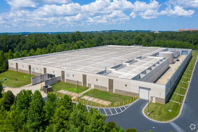
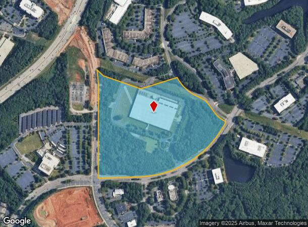
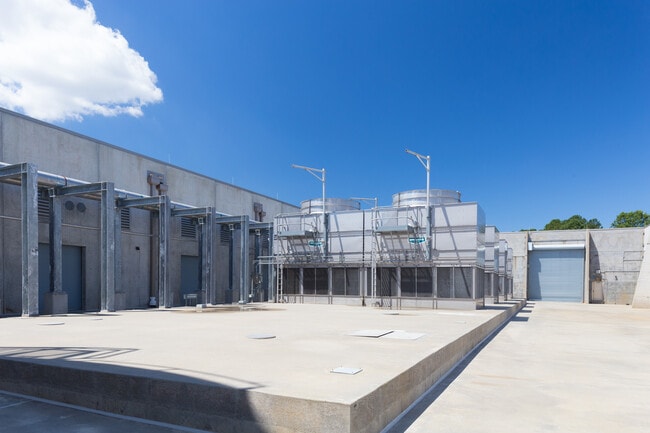
4905 N Point Pkwy
Scientificpharmaceuticalmedicalresearchfacility
Fulton
X
Georgia
13121C0067F
38.80 AC
2024
N Fulton/Forsyth Cnty
2025
Atlanta
011618
Atlanta-Sandy Springs-Roswell, GA
185,000 SF
12-2990-0850-043-4
DEMOGRAPHICS near 4905 N Point Pkwy
1 Mile
3 Mile
5 Mile
2024 Total Population
6,368
68,120
197,392
2029 Population
6,587
69,550
203,360
Pop Growth 2024-2029
+ 3.44%
+ 2.10%
+ 3.02%
Average Age
40
40
39
2024 Total Households
2,803
26,093
73,357
HH Growth 2024-2029
+ 3.53%
+ 2.33%
+ 3.14%
Median Household Inc
$127,661
$128,903
$124,826
Avg Household Size
2.30
2.50
2.60
2024 Avg HH Vehicles
2.00
2.00
2.00
Median Home Value
$652,431
$500,795
$467,267
Median Year Built
2001
1994
1993
Nearby Places
Map Layers
Map Styles
 Street
 Aerial
- Restaurants
- Banks
- Shops
- Fitness
- Groceries
PUBLIC TRANSPORTATION
AIRPORT
Hartsfield - Jackson Atlanta International
DRIVE
WALK
Distance
Hartsfield - Jackson Atlanta International
50 min
34.8 mi
SALE & LEASE HISTORY
LISTING DATE
SALE/LEASE

May 15, 2017
For Lease
Feb 09, 2023
For Lease
Nearby Properties
Address
Land Use
TOTAL SIZE
Lot Size
Zoning
Address
Land Use
TOTAL SIZE
Lot Size
Zoning
1,080,765 SF
36.65 AC
MIX
Address
Land Use
TOTAL SIZE
Lot Size
Zoning
14,832,179 SF
50.89 AC
OI
Address
Land Use
TOTAL SIZE
Lot Size
Zoning
699,024 SF
6.79 AC
MIX
Address
Land Use
TOTAL SIZE
Lot Size
Zoning
4,705,880 SF
8.55 AC
OI
Address
Land Use
TOTAL SIZE
Lot Size
Zoning
415,701 SF
6.75 AC
OI
Address
Land Use
TOTAL SIZE
Lot Size
Zoning
3,459,339 SF
26.51 AC
OI
Address
Land Use
TOTAL SIZE
Lot Size
Zoning
330,549 SF
68.46 AC
CUP
Address
Land Use
TOTAL SIZE
Lot Size
Zoning
434,804 SF
4.96 AC
Address
Land Use
TOTAL SIZE
Lot Size
Zoning
3,617,271 SF
29 AC
CUP
Address
Land Use
TOTAL SIZE
Lot Size
Zoning
604,953 SF
3.30 AC
MIX
Address
Land Use
TOTAL SIZE
Lot Size
Zoning
260,648 SF
34.20 AC
C3C
Address
Land Use
TOTAL SIZE
Lot Size
Zoning
241,349 SF
35 AC
OI
Address
Land Use
TOTAL SIZE
Lot Size
Zoning
1,159,560 SF
7.12 AC
CUP
Address
Land Use
TOTAL SIZE
Lot Size
Zoning
2,674,992 SF
28.94 AC
R4C
Address
Land Use
TOTAL SIZE
Lot Size
Zoning
1,297,776 SF
34.75 AC
CUP
Address
Land Use
TOTAL SIZE
Lot Size
Zoning
303,485 SF
1.44 AC
C2
Address
Land Use
TOTAL SIZE
Lot Size
Zoning
666,599 SF
24.20 AC
PSC
Address
Land Use
TOTAL SIZE
Lot Size
Zoning
237,995 SF
23 AC
TRC
Address
Land Use
TOTAL SIZE
Lot Size
Zoning
247,639 SF
0.68 AC
MIX
Address
Land Use
TOTAL SIZE
Lot Size
Zoning
761,850 SF
4.77 AC
OI
Address
Land Use
TOTAL SIZE
Lot Size
Zoning
2,045,850 SF
21.23 AC
CUP
Address
Land Use
TOTAL SIZE
Lot Size
Zoning
308,494 SF
2.64 AC
OI
Address
Land Use
TOTAL SIZE
Lot Size
Zoning
1,854,951 SF
33.30 AC
CUP
Address
Land Use
TOTAL SIZE
Lot Size
Zoning
367,876 SF
41.40 AC
PSC
Address
Land Use
TOTAL SIZE
Lot Size
Zoning
550,076 SF
45.25 AC
OIC
Address
Land Use
TOTAL SIZE
Lot Size
Zoning
2,101,414 SF
11 AC
CUP
Address
Land Use
TOTAL SIZE
Lot Size
Zoning
2,480,205 SF
37.86 AC
C1
Address
Land Use
TOTAL SIZE
Lot Size
Zoning
588,244 SF
11.80 AC
R4
Address
Land Use
TOTAL SIZE
Lot Size
Zoning
253,296 SF
1.34 AC
MIX
Address
Land Use
TOTAL SIZE
Lot Size
Zoning
396,000 SF
43.42 AC
C1
The World's #1 Commercial Real Estate Marketplace
Connect with us
© 2025 CoStar Group
The information above has been obtained from sources believed reliable. While we do not doubt its accuracy we have not verified it and make no guarantee, warranty or representation about it. It is your responsibility to independently confirm its accuracy and completeness. Any projections, opinions, assumptions, or estimates used are for example only and do not represent the current or future performance of the property. The value of this transaction to you depends on tax and other factors which should be evaluated by your tax, financial, and legal advisors. You and your advisors should conduct a careful, independent investigation of the property to determine to your satisfaction the suitability of the property for your needs.