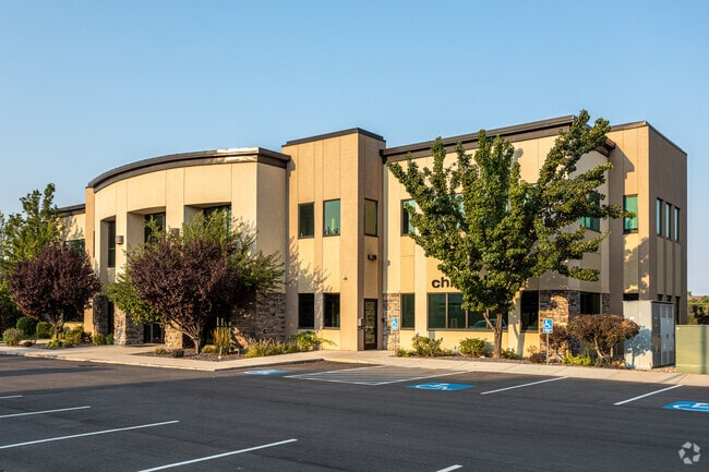
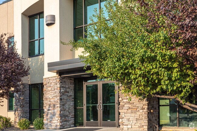
Property Record
4905 S 1500 W, Ogden, UT 84405
NEARBY LISTINGS FOR SALE OR LEASE
Property Detail
4905 S 1500 W
08-608-0001
Broookhaven Amended Plat A P U D
Officebuilding
ALL OF THE COMMON AREA WITHIN BROOKHAVEN AMENDED PLAT, A PLANNED UNIT DEVELOPMENT, RIVERDALE CITY, WEBER COUNTY, UTAH. [NOTE:
X
Weber
49057C0417F
Utah
0
0.26 AC
2025
Davis/Weber Counties
2105121030
Salt Lake City
13,850 SF
Ogden-Clearfield, UT
DEMOGRAPHICS near 4905 S 1500 W
1 Mile
3 Mile
5 Mile
2024 Total Population
10,675
79,504
205,337
2029 Population
11,502
85,262
220,292
Pop Growth 2024-2029
+ 7.75%
+ 7.24%
+ 7.28%
Average Age
36
35
35
2024 Total Households
3,974
26,969
69,227
HH Growth 2024-2029
+ 7.93%
+ 7.42%
+ 7.47%
Median Household Inc
$62,177
$71,093
$72,094
Avg Household Size
2.70
2.90
2.90
2024 Avg HH Vehicles
2.00
2.00
2.00
Median Home Value
$304,875
$329,533
$357,254
Median Year Built
1976
1983
1985
Nearby Places
Map Layers
Map Styles
 Street
 Aerial
- Restaurants
- Banks
- Shops
- Fitness
- Groceries
PUBLIC TRANSPORTATION
COMMUTER RAIL
Roy (FrontRunner North - Utah Transit Authority (UTA))
DRIVE
WALK
Distance
Roy (FrontRunner North - Utah Transit Authority (UTA))
7 min
3.2 mi
Ogden (FrontRunner North - Utah Transit Authority (UTA))
DRIVE
WALK
Distance
Ogden (FrontRunner North - Utah Transit Authority (UTA))
10 min
5.0 mi
AIRPORT
Salt Lake City International
DRIVE
WALK
Distance
Salt Lake City International
43 min
35.2 mi
Freight Ports
Port of Stockton
DRIVE
WALK
Distance
Port of Stockton
743 min
725.5 mi
SALE & LEASE HISTORY
LISTING DATE
SALE/LEASE

Sep 25, 2016
For Lease
Oct 16, 2019
For Lease
Mar 30, 2023
For Lease
Nearby Properties
Address
Land Use
TOTAL SIZE
Lot Size
Zoning
Address
Land Use
TOTAL SIZE
Lot Size
Zoning
200,509 SF
12.75 AC
Address
Land Use
TOTAL SIZE
Lot Size
Zoning
35,219 SF
58.98 AC
Address
Land Use
TOTAL SIZE
Lot Size
Zoning
7,492 SF
8.96 AC
Address
Land Use
TOTAL SIZE
Lot Size
Zoning
83,038 SF
7.54 AC
Address
Land Use
TOTAL SIZE
Lot Size
Zoning
71,940 SF
11 AC
Address
Land Use
TOTAL SIZE
Lot Size
Zoning
98,660 SF
3.18 AC
Address
Land Use
TOTAL SIZE
Lot Size
Zoning
8,580 SF
6.40 AC
Address
Land Use
TOTAL SIZE
Lot Size
Zoning
115,094 SF
13.88 AC
Address
Land Use
TOTAL SIZE
Lot Size
Zoning
225,497 SF
20.33 AC
Address
Land Use
TOTAL SIZE
Lot Size
Zoning
255,596 SF
15.98 AC
Address
Land Use
TOTAL SIZE
Lot Size
Zoning
23,932 SF
5.53 AC
Address
Land Use
TOTAL SIZE
Lot Size
Zoning
10,440 SF
4.24 AC
Address
Land Use
TOTAL SIZE
Lot Size
Zoning
139,574 SF
9.30 AC
Address
Land Use
TOTAL SIZE
Lot Size
Zoning
292,364 SF
24.15 AC
Address
Land Use
TOTAL SIZE
Lot Size
Zoning
17,220 SF
218.11 AC
Address
Land Use
TOTAL SIZE
Lot Size
Zoning
48,290 SF
7.95 AC
Address
Land Use
TOTAL SIZE
Lot Size
Zoning
59,367 SF
5.90 AC
Address
Land Use
TOTAL SIZE
Lot Size
Zoning
367,709 SF
34 AC
Address
Land Use
TOTAL SIZE
Lot Size
Zoning
13,590 SF
2.85 AC
The World's #1 Commercial Real Estate Marketplace
Connect with us
© 2025 CoStar Group
The information above has been obtained from sources believed reliable. While we do not doubt its accuracy we have not verified it and make no guarantee, warranty or representation about it. It is your responsibility to independently confirm its accuracy and completeness. Any projections, opinions, assumptions, or estimates used are for example only and do not represent the current or future performance of the property. The value of this transaction to you depends on tax and other factors which should be evaluated by your tax, financial, and legal advisors. You and your advisors should conduct a careful, independent investigation of the property to determine to your satisfaction the suitability of the property for your needs.