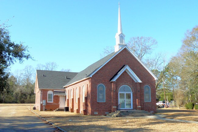
Property Record
4905 Saint Stephens Rd, Eight Mile, AL 36613

Property Detail
4905 Saint Stephens Rd
23-06-24-3-002-006
BEG SE COR OF NE 1/4 OF SW 1/4 SECT 24 T3S R2W RUN W ALG S/L OF NE 1/4 OF SW 1/4 514.7 FT TH N 47 DEG 06 MIN E 336 FT THEN N
Recreationalentertainmentgeneral
Mobile
B and X Area of moderate flood hazard, usually the area between the limits of the 100-year and 500-year floods.
Alabama
0
3.17 AC
2025
Prichard/Saraland
006103
Mobile
4,692 SF
Mobile, AL
NEARBY LISTINGS FOR SALE OR LEASE
DEMOGRAPHICS near 4905 Saint Stephens Rd
1 mile
3 mile
5 mile
2024 Total Population
2,509
20,725
74,778
2029 Population
2,521
20,883
75,202
Pop Growth 2024-2029
+ 0.48%
+ 0.76%
+ 0.57%
Average Age
41
40
41
2024 Total Households
880
7,872
29,003
HH Growth 2024-2029
+ 0.45%
+ 0.74%
+ 0.64%
Median Household Inc
$45,845
$42,391
$45,241
Avg Household Size
2.60
2.50
2.40
2024 Avg HH Vehicles
2.00
2.00
2.00
Median Home Value
$112,212
$105,741
$134,733
Median Year Built
1981
1973
1971
Nearby Places
Map Layers
Map Styles
 Street
 Aerial
Transit
 Traffic
 Biking
Places
Listings with unknown addresses are not visible on the map
- Restaurants
- Banks
- Shops
- Fitness
- Groceries
PUBLIC TRANSPORTATION
AIRPORT
Mobile Regional
Drive
Walk
Distance
Mobile Regional
27 min
11.7 mi
Mobile International
Drive
Walk
Distance
Mobile International
21 min
14.3 mi
Nearby Properties
Address
Land Use
TOTAL SIZE
Lot Size
Zoning
Address
Land Use
TOTAL SIZE
Lot Size
Zoning
63,390 SF
107.45 AC
Address
Land Use
TOTAL SIZE
Lot Size
Zoning
35,775 SF
22.48 AC
Address
Land Use
TOTAL SIZE
Lot Size
Zoning
35,828 SF
26.30 AC
Address
Land Use
TOTAL SIZE
Lot Size
Zoning
187,257 SF
33.10 AC
Address
Land Use
TOTAL SIZE
Lot Size
Zoning
15,960 SF
11.06 AC
Address
Land Use
TOTAL SIZE
Lot Size
Zoning
93,199 SF
622 AC
Address
Land Use
TOTAL SIZE
Lot Size
Zoning
57,084 SF
1.97 AC
Address
Land Use
TOTAL SIZE
Lot Size
Zoning
53,850 SF
12 AC
Address
Land Use
TOTAL SIZE
Lot Size
Zoning
45,980 SF
10.72 AC
Address
Land Use
TOTAL SIZE
Lot Size
Zoning
54,965 SF
1.97 AC
Address
Land Use
TOTAL SIZE
Lot Size
Zoning
87,532 SF
17 AC
Address
Land Use
TOTAL SIZE
Lot Size
Zoning
86,174 SF
9.30 AC
Address
Land Use
TOTAL SIZE
Lot Size
Zoning
94,787 SF
18 AC
Address
Land Use
TOTAL SIZE
Lot Size
Zoning
40,245 SF
1.99 AC
Address
Land Use
TOTAL SIZE
Lot Size
Zoning
48,304 SF
3.28 AC
Address
Land Use
TOTAL SIZE
Lot Size
Zoning
89,556 SF
18 AC
Address
Land Use
TOTAL SIZE
Lot Size
Zoning
58,624 SF
8.30 AC
Address
Land Use
TOTAL SIZE
Lot Size
Zoning
17,300 SF
7.17 AC
Address
Land Use
TOTAL SIZE
Lot Size
Zoning
17,422 SF
2.68 AC
Address
Land Use
TOTAL SIZE
Lot Size
Zoning
60,446 SF
2.67 AC
Address
Land Use
TOTAL SIZE
Lot Size
Zoning
45,468 SF
3.91 AC
Address
Land Use
TOTAL SIZE
Lot Size
Zoning
44,368 SF
5.20 AC
Address
Land Use
TOTAL SIZE
Lot Size
Zoning
8,244 SF
8.47 AC
Address
Land Use
TOTAL SIZE
Lot Size
Zoning
46,492 SF
17 AC
Address
Land Use
TOTAL SIZE
Lot Size
Zoning
69,369 SF
6.60 AC
Address
Land Use
TOTAL SIZE
Lot Size
Zoning
40,757 SF
7.14 AC
Address
Land Use
TOTAL SIZE
Lot Size
Zoning
11,538 SF
4.84 AC
Address
Land Use
TOTAL SIZE
Lot Size
Zoning
196,257 SF
6.90 AC
Address
Land Use
TOTAL SIZE
Lot Size
Zoning
32,457 SF
1.54 AC
Address
Land Use
TOTAL SIZE
Lot Size
Zoning
4,158 SF
8.23 AC
The World's #1 Commercial Real Estate Marketplace
Connect with us
© 2026 CoStar Group
The information above has been obtained from sources believed reliable. While we do not doubt its accuracy we have not verified it and make no guarantee, warranty or representation about it. It is your responsibility to independently confirm its accuracy and completeness. Any projections, opinions, assumptions, or estimates used are for example only and do not represent the current or future performance of the property. The value of this transaction to you depends on tax and other factors which should be evaluated by your tax, financial, and legal advisors. You and your advisors should conduct a careful, independent investigation of the property to determine to your satisfaction the suitability of the property for your needs.