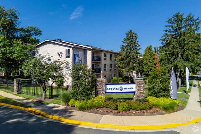
Property Record
4905 Southland Ave, Alexandria, VA 22312

NEARBY LISTINGS FOR SALE OR LEASE
Property Detail
4905 Southland Ave
Washington-Arlington-Alexandria, DC-VA-MD-WV
Lincolnia
0723-01-0054
LINCOLNIA
Apartment
Fairfax
A
Virginia
5100540050D
54
2024
16.45 AC
2025
Lincolnia
452502
Washington, DC
431,097 SF
DEMOGRAPHICS near 4905 Southland Ave
1 Mile
3 Mile
5 Mile
2024 Total Population
27,785
196,781
523,870
2029 Population
27,045
193,935
515,023
Pop Growth 2024-2029
(2.66%)
(1.45%)
(1.69%)
Average Age
38
39
39
2024 Total Households
11,092
79,228
209,695
HH Growth 2024-2029
(2.98%)
(1.56%)
(1.79%)
Median Household Inc
$83,223
$97,047
$111,628
Avg Household Size
2.40
2.40
2.40
2024 Avg HH Vehicles
2.00
2.00
2.00
Median Home Value
$478,518
$552,433
$633,055
Median Year Built
1973
1974
1973
Nearby Places
Map Layers
Map Styles
 Street
 Aerial
- Restaurants
- Banks
- Shops
- Fitness
- Groceries
PUBLIC TRANSPORTATION
COMMUTER RAIL
Backlick Road (Manassas Line - Virginia Railway Express)
DRIVE
WALK
Distance
Backlick Road (Manassas Line - Virginia Railway Express)
8 min
3.9 mi
Franconia-Springfield (Fredericksburg Line - Virginia Railway Express)
DRIVE
WALK
Distance
Franconia-Springfield (Fredericksburg Line - Virginia Railway Express)
14 min
6.1 mi
AIRPORT
Ronald Reagan Washington Ntl
DRIVE
WALK
Distance
Ronald Reagan Washington Ntl
14 min
7.5 mi
Washington Dulles International
DRIVE
WALK
Distance
Washington Dulles International
42 min
25.6 mi
Freight Ports
Port of Baltimore
DRIVE
WALK
Distance
Port of Baltimore
72 min
48.7 mi
Nearby Properties
Address
Land Use
TOTAL SIZE
Lot Size
Zoning
Address
Land Use
TOTAL SIZE
Lot Size
Zoning
1,732,719 SF
15.91 AC
CDD#4
Address
Land Use
TOTAL SIZE
Lot Size
Zoning
75.49 AC
RA
Address
Land Use
TOTAL SIZE
Lot Size
Zoning
1,174,771 SF
20.30 AC
RA
Address
Land Use
TOTAL SIZE
Lot Size
Zoning
782,494 SF
27.65 AC
R 12
Address
Land Use
TOTAL SIZE
Lot Size
Zoning
613,844 SF
499
Address
Land Use
TOTAL SIZE
Lot Size
Zoning
343,400 SF
12 AC
POS
Address
Land Use
TOTAL SIZE
Lot Size
Zoning
512,045 SF
12.94 AC
CDD#4
Address
Land Use
TOTAL SIZE
Lot Size
Zoning
60.60 AC
CDD#4
Address
Land Use
TOTAL SIZE
Lot Size
Zoning
474,000 SF
3.68 AC
CRMU/H
Address
Land Use
TOTAL SIZE
Lot Size
Zoning
30 AC
CDD#4
Address
Land Use
TOTAL SIZE
Lot Size
Zoning
460,082 SF
10.53 AC
CRMU/H
Address
Land Use
TOTAL SIZE
Lot Size
Zoning
498,506 SF
6.97 AC
350
Address
Land Use
TOTAL SIZE
Lot Size
Zoning
853,724 SF
32.32 AC
220
Address
Land Use
TOTAL SIZE
Lot Size
Zoning
670,449 SF
7.35 AC
400
Address
Land Use
TOTAL SIZE
Lot Size
Zoning
670,449 SF
5.34 AC
400
Address
Land Use
TOTAL SIZE
Lot Size
Zoning
429,735 SF
20 AC
560
Address
Land Use
TOTAL SIZE
Lot Size
Zoning
590,771 SF
6.83 AC
RC
Address
Land Use
TOTAL SIZE
Lot Size
Zoning
1,825 SF
10.74 AC
RA7-16
Address
Land Use
TOTAL SIZE
Lot Size
Zoning
328,506 SF
2.47 AC
CDD#17
Address
Land Use
TOTAL SIZE
Lot Size
Zoning
329,637 SF
23.39 AC
316
Address
Land Use
TOTAL SIZE
Lot Size
Zoning
5 AC
RC
Address
Land Use
TOTAL SIZE
Lot Size
Zoning
500,118 SF
8.73 AC
RB/R-8
Address
Land Use
TOTAL SIZE
Lot Size
Zoning
454,000 SF
12.82 AC
RA
Address
Land Use
TOTAL SIZE
Lot Size
Zoning
608,913 SF
3.67 AC
400
Address
Land Use
TOTAL SIZE
Lot Size
Zoning
1 SF
6.68 AC
RC
Address
Land Use
TOTAL SIZE
Lot Size
Zoning
3,504 SF
3.37 AC
400
Address
Land Use
TOTAL SIZE
Lot Size
Zoning
328,663 SF
3.29 AC
CDD#4
Address
Land Use
TOTAL SIZE
Lot Size
Zoning
452,682 SF
20.74 AC
220
Address
Land Use
TOTAL SIZE
Lot Size
Zoning
7,174 SF
1 AC
C-1
The World's #1 Commercial Real Estate Marketplace
Connect with us
© 2025 CoStar Group
The information above has been obtained from sources believed reliable. While we do not doubt its accuracy we have not verified it and make no guarantee, warranty or representation about it. It is your responsibility to independently confirm its accuracy and completeness. Any projections, opinions, assumptions, or estimates used are for example only and do not represent the current or future performance of the property. The value of this transaction to you depends on tax and other factors which should be evaluated by your tax, financial, and legal advisors. You and your advisors should conduct a careful, independent investigation of the property to determine to your satisfaction the suitability of the property for your needs.