Property Record
4909 N Commerce Dr, Atlanta, GA 30344


Save to a Folder
{{folder.Name}}
{{folder.ListingIds.length}} Properties
{{folder.ListingIds.length}} Property
Create a New Folder
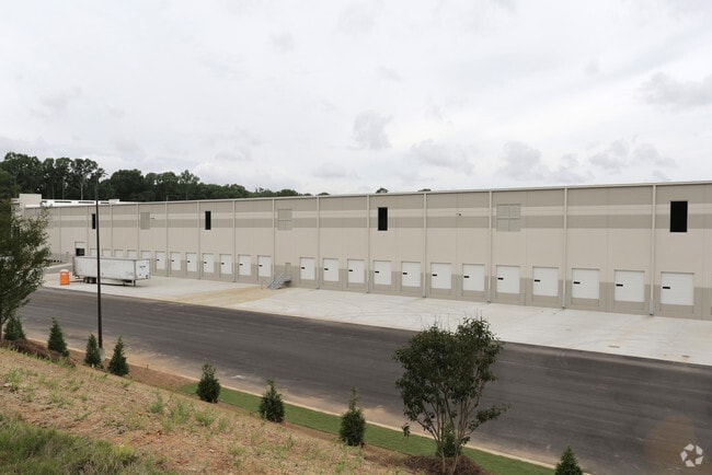
Property Detail
4909 N Commerce Dr
Warehouse
FULTON
R3
Georgia
B and X Area of moderate flood hazard, usually the area between the limits of the 100-year and 500-year floods.
49.22 AC
2023
Airport/North Clayton
2025
Atlanta
011306
Atlanta-Sandy Springs-Roswell, GA
619,194 SF
13-0032-LL-045-1
NEARBY LISTINGS FOR SALE OR LEASE
DEMOGRAPHICS near 4909 N Commerce Dr
1 mile
3 mile
5 mile
2025 Total Population
8,012
55,562
156,632
2030 Population
8,282
57,660
160,873
Pop Growth 2025-2030
+ 3.37%
+ 3.78%
+ 2.71%
Average Age
34
37
38
2025 Total Households
3,111
21,969
61,651
HH Growth 2025-2030
+ 3.21%
+ 3.51%
+ 2.54%
Median Household Inc
$49,493
$60,512
$63,302
Avg Household Size
2.50
2.50
2.50
2025 Avg HH Vehicles
1.00
1.00
2.00
Median Home Value
$307,615
$286,896
$283,051
Median Year Built
1979
1987
1985
Nearby Places
Map Layers
Map Styles
 Street
 Aerial
Layers
 Traffic
 Biking
Places
Listings with unknown addresses are not visible on the map
- Restaurants
- Banks
- Shops
- Fitness
- Groceries
PUBLIC TRANSPORTATION
AIRPORT
Hartsfield - Jackson Atlanta International
Drive
Walk
Distance
Hartsfield - Jackson Atlanta International
15 min
8.6 mi
Freight Ports
Georgia Ports - Savannah
Drive
Walk
Distance
Georgia Ports - Savannah
277 min
245.9 mi
SALE & LEASE HISTORY
LISTING DATE
SALE/LEASE

Sep 25, 2016
For Lease
Nearby Properties
Address
Land Use
TOTAL SIZE
Lot Size
Zoning
Address
Land Use
TOTAL SIZE
Lot Size
Zoning
2,666 SF
46.88 AC
BP
Address
Land Use
TOTAL SIZE
Lot Size
Zoning
2,666 SF
0.43 AC
Address
Land Use
TOTAL SIZE
Lot Size
Zoning
2,666 SF
0.43 AC
Address
Land Use
TOTAL SIZE
Lot Size
Zoning
2,666 SF
0.43 AC
Address
Land Use
TOTAL SIZE
Lot Size
Zoning
2,666 SF
0.43 AC
Address
Land Use
TOTAL SIZE
Lot Size
Zoning
2,666 SF
0.43 AC
Address
Land Use
TOTAL SIZE
Lot Size
Zoning
2,666 SF
0.43 AC
Address
Land Use
TOTAL SIZE
Lot Size
Zoning
2,666 SF
0.43 AC
Address
Land Use
TOTAL SIZE
Lot Size
Zoning
2,666 SF
0.43 AC
Address
Land Use
TOTAL SIZE
Lot Size
Zoning
2,666 SF
0.43 AC
Address
Land Use
TOTAL SIZE
Lot Size
Zoning
2,666 SF
0.43 AC
Address
Land Use
TOTAL SIZE
Lot Size
Zoning
293,211 SF
23.51 AC
C
Address
Land Use
TOTAL SIZE
Lot Size
Zoning
929,571 SF
65.66 AC
M1
Address
Land Use
TOTAL SIZE
Lot Size
Zoning
270,503 SF
4.56 AC
C
Address
Land Use
TOTAL SIZE
Lot Size
Zoning
2,329,350 SF
32.55 AC
A
Address
Land Use
TOTAL SIZE
Lot Size
Zoning
196,294 SF
0.49 AC
R1
Address
Land Use
TOTAL SIZE
Lot Size
Zoning
356,458 SF
18.72 AC
PDMU
Address
Land Use
TOTAL SIZE
Lot Size
Zoning
115.30 AC
I
Address
Land Use
TOTAL SIZE
Lot Size
Zoning
6,402,340 SF
22.62 AC
MF
Address
Land Use
TOTAL SIZE
Lot Size
Zoning
4,455,803 SF
16.39 AC
C2
Address
Land Use
TOTAL SIZE
Lot Size
Zoning
6,069,632 SF
26.42 AC
R4
Address
Land Use
TOTAL SIZE
Lot Size
Zoning
1,231,833 SF
15.51 AC
C2
Address
Land Use
TOTAL SIZE
Lot Size
Zoning
330,838 SF
13.71 AC
PDMU
Address
Land Use
TOTAL SIZE
Lot Size
Zoning
4,381,104 SF
26.70 AC
AG1
Address
Land Use
TOTAL SIZE
Lot Size
Zoning
235,301 SF
27.20 AC
C2MC
Address
Land Use
TOTAL SIZE
Lot Size
Zoning
32,000 SF
8.86 AC
C
Address
Land Use
TOTAL SIZE
Lot Size
Zoning
137,475 SF
2 AC
C
Address
Land Use
TOTAL SIZE
Lot Size
Zoning
920,396 SF
62.40 AC
R3
Address
Land Use
TOTAL SIZE
Lot Size
Zoning
997,011 SF
68.07 AC
M1
Address
Land Use
TOTAL SIZE
Lot Size
Zoning
663,520 SF
62.96 AC
C1
The World's #1 Commercial Real Estate Marketplace
Connect with us
© 2026 CoStar Group
The information above has been obtained from sources believed reliable. While we do not doubt its accuracy we have not verified it and make no guarantee, warranty or representation about it. It is your responsibility to independently confirm its accuracy and completeness. Any projections, opinions, assumptions, or estimates used are for example only and do not represent the current or future performance of the property. The value of this transaction to you depends on tax and other factors which should be evaluated by your tax, financial, and legal advisors. You and your advisors should conduct a careful, independent investigation of the property to determine to your satisfaction the suitability of the property for your needs.