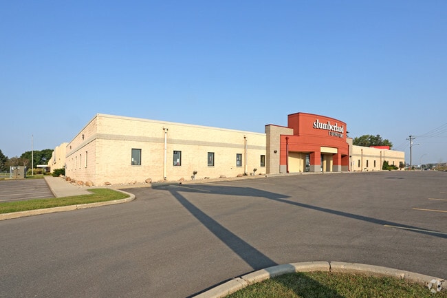
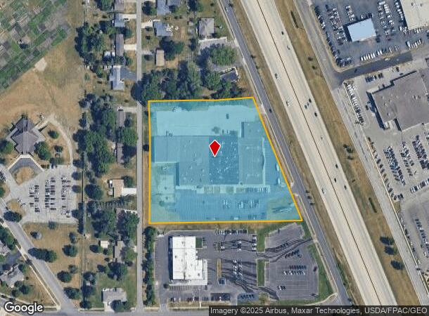
Property Record
4909 W Frontage Highway 52 Rd Nw, Rochester, MN 55901
NEARBY LISTINGS FOR SALE OR LEASE
Property Detail
4909 W Frontage Highway 52 Rd Nw
74.16.13.075712
City Lands 107-14-16
Storebuilding
SECT-16 TWP-107 RANGE-014 CITY LANDS 107-14-16 5.85 AC TH PT NE14 DES AS FOL COM AT SW COR SD NE14 TH NELY AL S LINE SD NE14
X
Olmsted
27109C0135D
Minnesota
2025
5.77 AC
2024
Rochester
001401
Other Market Areas
78,236 SF
Rochester, MN
DEMOGRAPHICS near 4909 W Frontage Highway 52 Rd Nw
1 Mile
3 Mile
5 Mile
2024 Total Population
9,650
49,174
96,008
2029 Population
9,783
50,249
98,298
Pop Growth 2024-2029
+ 1.38%
+ 2.19%
+ 2.39%
Average Age
39
38
39
2024 Total Households
3,750
19,552
39,955
HH Growth 2024-2029
+ 1.23%
+ 2.10%
+ 2.45%
Median Household Inc
$78,403
$84,162
$84,210
Avg Household Size
2.40
2.40
2.30
2024 Avg HH Vehicles
2.00
2.00
2.00
Median Home Value
$272,784
$269,021
$285,007
Median Year Built
1992
1990
1986
Nearby Places
Map Layers
Map Styles
 Street
 Aerial
- Restaurants
- Banks
- Shops
- Fitness
- Groceries
PUBLIC TRANSPORTATION
AIRPORT
Rochester International
DRIVE
WALK
Distance
Rochester International
18 min
12.8 mi
Freight Ports
Port Milwaukee
DRIVE
WALK
Distance
Port Milwaukee
311 min
282.3 mi
SALE & LEASE HISTORY
LISTING DATE
SALE/LEASE

Sep 25, 2017
For Lease
Sep 21, 2017
For Lease
Dec 04, 2024
For Lease
Nearby Properties
Address
Land Use
TOTAL SIZE
Lot Size
Zoning
Address
Land Use
TOTAL SIZE
Lot Size
Zoning
1,232,028 SF
2.03 AC
Address
Land Use
TOTAL SIZE
Lot Size
Zoning
271,310 SF
27.90 AC
Address
Land Use
TOTAL SIZE
Lot Size
Zoning
6,082 SF
31.75 AC
Address
Land Use
TOTAL SIZE
Lot Size
Zoning
960 SF
38.12 AC
Address
Land Use
TOTAL SIZE
Lot Size
Zoning
13,946 SF
34.10 AC
Address
Land Use
TOTAL SIZE
Lot Size
Zoning
236,769 SF
33.30 AC
Address
Land Use
TOTAL SIZE
Lot Size
Zoning
12,016 SF
20.31 AC
Address
Land Use
TOTAL SIZE
Lot Size
Zoning
2,420 SF
10.37 AC
Address
Land Use
TOTAL SIZE
Lot Size
Zoning
195,039 SF
8.25 AC
Address
Land Use
TOTAL SIZE
Lot Size
Zoning
53.73 AC
Address
Land Use
TOTAL SIZE
Lot Size
Zoning
167.09 AC
Address
Land Use
TOTAL SIZE
Lot Size
Zoning
4.63 AC
Address
Land Use
TOTAL SIZE
Lot Size
Zoning
136,031 SF
35.28 AC
Address
Land Use
TOTAL SIZE
Lot Size
Zoning
170,843 SF
13.66 AC
Address
Land Use
TOTAL SIZE
Lot Size
Zoning
3,024 SF
4.93 AC
Address
Land Use
TOTAL SIZE
Lot Size
Zoning
3,915 SF
12.56 AC
Address
Land Use
TOTAL SIZE
Lot Size
Zoning
10,920 SF
38.88 AC
Address
Land Use
TOTAL SIZE
Lot Size
Zoning
Address
Land Use
TOTAL SIZE
Lot Size
Zoning
38.64 AC
Address
Land Use
TOTAL SIZE
Lot Size
Zoning
117,897 SF
34.12 AC
Address
Land Use
TOTAL SIZE
Lot Size
Zoning
2,880 SF
9.49 AC
Address
Land Use
TOTAL SIZE
Lot Size
Zoning
77,176 SF
11.05 AC
Address
Land Use
TOTAL SIZE
Lot Size
Zoning
66,713 SF
8.79 AC
Address
Land Use
TOTAL SIZE
Lot Size
Zoning
528 SF
15.22 AC
Address
Land Use
TOTAL SIZE
Lot Size
Zoning
16,792 SF
7.07 AC
Address
Land Use
TOTAL SIZE
Lot Size
Zoning
44,352 SF
10.93 AC
Address
Land Use
TOTAL SIZE
Lot Size
Zoning
23.22 AC
Address
Land Use
TOTAL SIZE
Lot Size
Zoning
308,992 SF
8.53 AC
Address
Land Use
TOTAL SIZE
Lot Size
Zoning
23,268 SF
10.22 AC
Address
Land Use
TOTAL SIZE
Lot Size
Zoning
93,522 SF
3.70 AC
The World's #1 Commercial Real Estate Marketplace
Connect with us
© 2025 CoStar Group
The information above has been obtained from sources believed reliable. While we do not doubt its accuracy we have not verified it and make no guarantee, warranty or representation about it. It is your responsibility to independently confirm its accuracy and completeness. Any projections, opinions, assumptions, or estimates used are for example only and do not represent the current or future performance of the property. The value of this transaction to you depends on tax and other factors which should be evaluated by your tax, financial, and legal advisors. You and your advisors should conduct a careful, independent investigation of the property to determine to your satisfaction the suitability of the property for your needs.