Property Record
491 Agnes St, Bastrop, TX 78602
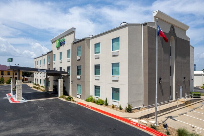


Property Detail
491 Agnes St
Austin-Round Rock-San Marcos, TX
BASTROP WEST COMMERCIAL SEC 2, LOT 4B (RESUB), ACRES 1.3740
78375
BASTROP
Commercialnec
Texas
C and X Area of minimal flood hazard, usually depicted on FIRMs as above the 500-year flood level.
4b
2024
1.37 AC
2025
San Marcos/Austin Surrounding
950403
Austin
33,485 SF
NEARBY LISTINGS FOR SALE OR LEASE
-
-
View all Bastrop listings for sale on LoopNet.com
DEMOGRAPHICS near 491 Agnes St
1 mile
3 mile
5 mile
2025 Total Population
3,829
19,267
29,132
2030 Population
4,514
22,218
33,552
Pop Growth 2025-2030
+ 17.89%
+ 15.32%
+ 15.17%
Average Age
42
40
41
2025 Total Households
1,592
7,459
10,885
HH Growth 2025-2030
+ 18.66%
+ 15.90%
+ 15.81%
Median Household Inc
$71,893
$78,212
$81,084
Avg Household Size
2.30
2.50
2.50
2025 Avg HH Vehicles
2.00
2.00
2.00
Median Home Value
$370,651
$353,781
$353,688
Median Year Built
2010
2004
2004
Nearby Places
Map Layers
Map Styles
 Street
 Aerial
Layers
 Traffic
 Biking
Places
Listings with unknown addresses are not visible on the map
- Restaurants
- Banks
- Shops
- Fitness
- Groceries
PUBLIC TRANSPORTATION
AIRPORT
Austin-Bergstrom International
Drive
Walk
Distance
Austin-Bergstrom International
38 min
25.6 mi
Freight Ports
Calhoun Port
Drive
Walk
Distance
Calhoun Port
169 min
142.6 mi
SALE & LEASE HISTORY
LISTING DATE
SALE/LEASE

Sep 24, 2016
For Sale
Feb 24, 2017
For Sale
Apr 25, 2017
For Sale
Nearby Properties
Address
Land Use
TOTAL SIZE
Lot Size
Zoning
Address
Land Use
TOTAL SIZE
Lot Size
Zoning
22.60 AC
Address
Land Use
TOTAL SIZE
Lot Size
Zoning
120,000 SF
12.54 AC
Address
Land Use
TOTAL SIZE
Lot Size
Zoning
38,112 SF
24.16 AC
Address
Land Use
TOTAL SIZE
Lot Size
Zoning
25.59 AC
Address
Land Use
TOTAL SIZE
Lot Size
Zoning
140,496 SF
8.05 AC
Address
Land Use
TOTAL SIZE
Lot Size
Zoning
140,878 SF
8.31 AC
Address
Land Use
TOTAL SIZE
Lot Size
Zoning
123,176 SF
29.42 AC
Address
Land Use
TOTAL SIZE
Lot Size
Zoning
83,994 SF
7.83 AC
Address
Land Use
TOTAL SIZE
Lot Size
Zoning
180,568 SF
23.98 AC
Address
Land Use
TOTAL SIZE
Lot Size
Zoning
105,020 SF
13.43 AC
Address
Land Use
TOTAL SIZE
Lot Size
Zoning
125,000 SF
11.98 AC
Address
Land Use
TOTAL SIZE
Lot Size
Zoning
87,953 SF
8.06 AC
Address
Land Use
TOTAL SIZE
Lot Size
Zoning
86,427 SF
23.38 AC
Address
Land Use
TOTAL SIZE
Lot Size
Zoning
65,206 SF
2.55 AC
Address
Land Use
TOTAL SIZE
Lot Size
Zoning
49,508 SF
6.58 AC
Address
Land Use
TOTAL SIZE
Lot Size
Zoning
169,350 SF
25.30 AC
Address
Land Use
TOTAL SIZE
Lot Size
Zoning
121,305 SF
16.06 AC
Address
Land Use
TOTAL SIZE
Lot Size
Zoning
24,788 SF
Address
Land Use
TOTAL SIZE
Lot Size
Zoning
59,941 SF
4.57 AC
Address
Land Use
TOTAL SIZE
Lot Size
Zoning
40,261 SF
15 AC
Address
Land Use
TOTAL SIZE
Lot Size
Zoning
173,350 SF
10.58 AC
Address
Land Use
TOTAL SIZE
Lot Size
Zoning
133,292 SF
2.67 AC
Address
Land Use
TOTAL SIZE
Lot Size
Zoning
69,508 SF
4.10 AC
Address
Land Use
TOTAL SIZE
Lot Size
Zoning
125,948 SF
12.76 AC
Address
Land Use
TOTAL SIZE
Lot Size
Zoning
54,856 SF
4.15 AC
Address
Land Use
TOTAL SIZE
Lot Size
Zoning
67,979 SF
4.08 AC
Address
Land Use
TOTAL SIZE
Lot Size
Zoning
47,126 SF
3.33 AC
Address
Land Use
TOTAL SIZE
Lot Size
Zoning
32,828 SF
4.02 AC
Address
Land Use
TOTAL SIZE
Lot Size
Zoning
62,734 SF
2.55 AC
Address
Land Use
TOTAL SIZE
Lot Size
Zoning
27,936 SF
5 AC
The World's #1 Commercial Real Estate Marketplace
Connect with us
© 2026 CoStar Group
The information above has been obtained from sources believed reliable. While we do not doubt its accuracy we have not verified it and make no guarantee, warranty or representation about it. It is your responsibility to independently confirm its accuracy and completeness. Any projections, opinions, assumptions, or estimates used are for example only and do not represent the current or future performance of the property. The value of this transaction to you depends on tax and other factors which should be evaluated by your tax, financial, and legal advisors. You and your advisors should conduct a careful, independent investigation of the property to determine to your satisfaction the suitability of the property for your needs.