Property Record
491 E Broad Ave, Rockingham, NC 28379


Property Detail
491 E Broad Ave
747317-01-1624
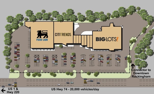
AC FOOD LION & S/E US 74
Commercialnec
RICHMOND
B3
North Carolina
AE The base floodplain where base flood elevations are provided. AE Zones are now used on new format FIRMs instead of A1-A30 Zones.
7.82 AC
2025
North Carolina Southeast Area
2025
Other Market Areas
970500
Rockingham, NC
32,284 SF
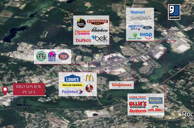
NEARBY LISTINGS FOR SALE OR LEASE
DEMOGRAPHICS near 491 E Broad Ave
1 mile
3 mile
5 mile
2025 Total Population
4,315
16,763
27,858
2030 Population
4,328
16,593
27,588
Pop Growth 2025-2030
+ 0.30%
(1.01%)
(0.97%)
Average Age
40
40
41
2025 Total Households
1,757
6,941
11,515
HH Growth 2025-2030
+ 0.51%
(1.12%)
(1.04%)
Median Household Inc
$27,789
$41,171
$42,237
Avg Household Size
2.30
2.30
2.40
2025 Avg HH Vehicles
1.00
2.00
2.00
Median Home Value
$109,829
$130,046
$134,267
Median Year Built
1964
1972
1974
Nearby Places
Map Layers
Map Styles
 Street
 Aerial
Layers
 Traffic
 Biking
Places
Listings with unknown addresses are not visible on the map
- Restaurants
- Banks
- Shops
- Fitness
- Groceries
PUBLIC TRANSPORTATION
COMMUTER RAIL
Hamlet Amtrak Station (Silver Star - Amtrak)
Drive
Walk
Distance
Hamlet Amtrak Station (Silver Star - Amtrak)
9 min
5.6 mi
Freight Ports
Port of Wilmington
Drive
Walk
Distance
Port of Wilmington
158 min
128.3 mi
SALE & LEASE HISTORY
LISTING DATE
SALE/LEASE

Jan 04, 2023
For Lease
Aug 09, 2017
For Lease
Nearby Properties
Address
Land Use
TOTAL SIZE
Lot Size
Zoning
Address
Land Use
TOTAL SIZE
Lot Size
Zoning
187,379 SF
43.43 AC
Address
Land Use
TOTAL SIZE
Lot Size
Zoning
131,657 SF
18.83 AC
Address
Land Use
TOTAL SIZE
Lot Size
Zoning
5,120 SF
15.36 AC
Address
Land Use
TOTAL SIZE
Lot Size
Zoning
66,923 SF
26.15 AC
Address
Land Use
TOTAL SIZE
Lot Size
Zoning
11,435 SF
2.04 AC
Address
Land Use
TOTAL SIZE
Lot Size
Zoning
25,854 SF
12.76 AC
I2
Address
Land Use
TOTAL SIZE
Lot Size
Zoning
20,240 SF
2.85 AC
Address
Land Use
TOTAL SIZE
Lot Size
Zoning
13,057 SF
1.78 AC
Address
Land Use
TOTAL SIZE
Lot Size
Zoning
156,574 SF
27.74 AC
B3
Address
Land Use
TOTAL SIZE
Lot Size
Zoning
20,280 SF
5.49 AC
Address
Land Use
TOTAL SIZE
Lot Size
Zoning
74,881 SF
11.40 AC
Address
Land Use
TOTAL SIZE
Lot Size
Zoning
42,140 SF
5.69 AC
Address
Land Use
TOTAL SIZE
Lot Size
Zoning
17,086 SF
4.92 AC
Address
Land Use
TOTAL SIZE
Lot Size
Zoning
15,903 SF
1.25 AC
Address
Land Use
TOTAL SIZE
Lot Size
Zoning
5.03 AC
B3
Address
Land Use
TOTAL SIZE
Lot Size
Zoning
361,307 SF
122.08 AC
Address
Land Use
TOTAL SIZE
Lot Size
Zoning
Address
Land Use
TOTAL SIZE
Lot Size
Zoning
93,600 SF
7.47 AC
HI
Address
Land Use
TOTAL SIZE
Lot Size
Zoning
4,810 SF
9 AC
Address
Land Use
TOTAL SIZE
Lot Size
Zoning
62,360 SF
10.16 AC
Address
Land Use
TOTAL SIZE
Lot Size
Zoning
11,572 SF
1.67 AC
Address
Land Use
TOTAL SIZE
Lot Size
Zoning
40,000 SF
9.32 AC
Address
Land Use
TOTAL SIZE
Lot Size
Zoning
13,200 SF
7.59 AC
Address
Land Use
TOTAL SIZE
Lot Size
Zoning
17,061 SF
3.13 AC
R12
Address
Land Use
TOTAL SIZE
Lot Size
Zoning
7,566 SF
9.40 AC
Address
Land Use
TOTAL SIZE
Lot Size
Zoning
15,000 SF
2.49 AC
B3
Address
Land Use
TOTAL SIZE
Lot Size
Zoning
7,325 SF
1.78 AC
Address
Land Use
TOTAL SIZE
Lot Size
Zoning
15,936 SF
2.43 AC
Address
Land Use
TOTAL SIZE
Lot Size
Zoning
34,529 SF
4.15 AC
R9
The World's #1 Commercial Real Estate Marketplace
Connect with us
© 2026 CoStar Group
The information above has been obtained from sources believed reliable. While we do not doubt its accuracy we have not verified it and make no guarantee, warranty or representation about it. It is your responsibility to independently confirm its accuracy and completeness. Any projections, opinions, assumptions, or estimates used are for example only and do not represent the current or future performance of the property. The value of this transaction to you depends on tax and other factors which should be evaluated by your tax, financial, and legal advisors. You and your advisors should conduct a careful, independent investigation of the property to determine to your satisfaction the suitability of the property for your needs.