Property Record
491 Highway 19 Blvd, Red Wing, MN 55066


NEARBY LISTINGS FOR SALE OR LEASE
-
-
View all Red Wing listings for sale on LoopNet.com
Property Detail
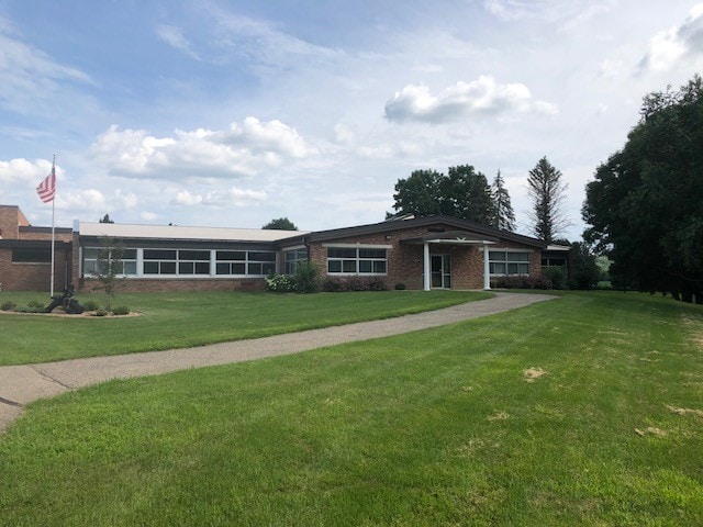
491 Highway 19 Blvd
Red Wing, MN
Section 29
55.729.0340
SECTION 29 4.19 AC ID# 27-0000-45800 PART OF N 1/2 OF SE 1/4 SEC 29 113 15 SEE IND CD 856 A 03/100 AC HWY EASE DOC#695945
Officebuilding
Goodhue
0
Minnesota
2025
4.19 AC
080202
Minnesota South Area
23,348 SF
Other Market Areas
DEMOGRAPHICS near 491 Highway 19 Blvd
1 mile
3 mile
5 mile
2024 Total Population
1,016
3,989
10,508
2029 Population
1,045
4,159
10,822
Pop Growth 2024-2029
+ 2.85%
+ 4.26%
+ 2.99%
Average Age
42
43
43
2024 Total Households
417
1,683
4,543
HH Growth 2024-2029
+ 2.88%
+ 4.28%
+ 2.99%
Median Household Inc
$73,783
$82,010
$68,704
Avg Household Size
2.40
2.30
2.30
2024 Avg HH Vehicles
2.00
2.00
2.00
Median Home Value
$246,929
$255,466
$237,641
Median Year Built
1978
1989
1978
Nearby Places
Map Layers
Map Styles
 Street
 Aerial
Transit
 Traffic
 Biking
Places
Listings with unknown addresses are not visible on the map
- Restaurants
- Banks
- Shops
- Fitness
- Groceries
PUBLIC TRANSPORTATION
COMMUTER RAIL
Drive
Walk
Distance
10 min
5.7 mi
AIRPORT
Minneapolis-St Paul International/Wold-Chamberlain
Drive
Walk
Distance
Minneapolis-St Paul International/Wold-Chamberlain
61 min
46.2 mi
SALE & LEASE HISTORY
LISTING DATE
SALE/LEASE

Sep 13, 2019
For Sale
Jun 28, 2018
For Lease
Nearby Properties
Address
Land Use
TOTAL SIZE
Lot Size
Zoning
Address
Land Use
TOTAL SIZE
Lot Size
Zoning
88,787 SF
19.15 AC
Address
Land Use
TOTAL SIZE
Lot Size
Zoning
192,379 SF
22.63 AC
Address
Land Use
TOTAL SIZE
Lot Size
Zoning
173,191 SF
17.94 AC
Address
Land Use
TOTAL SIZE
Lot Size
Zoning
193,336 SF
15.04 AC
Address
Land Use
TOTAL SIZE
Lot Size
Zoning
120,692 SF
21.92 AC
Address
Land Use
TOTAL SIZE
Lot Size
Zoning
205,520 SF
16.43 AC
Address
Land Use
TOTAL SIZE
Lot Size
Zoning
68,142 SF
9.04 AC
Address
Land Use
TOTAL SIZE
Lot Size
Zoning
77,616 SF
100 AC
Address
Land Use
TOTAL SIZE
Lot Size
Zoning
1,800 SF
4.50 AC
Address
Land Use
TOTAL SIZE
Lot Size
Zoning
58,552 SF
2.21 AC
Address
Land Use
TOTAL SIZE
Lot Size
Zoning
52,602 SF
9.91 AC
Address
Land Use
TOTAL SIZE
Lot Size
Zoning
55,552 SF
3.74 AC
Address
Land Use
TOTAL SIZE
Lot Size
Zoning
13,653 SF
4.89 AC
Address
Land Use
TOTAL SIZE
Lot Size
Zoning
61,206 SF
4.55 AC
Address
Land Use
TOTAL SIZE
Lot Size
Zoning
56,169 SF
2.21 AC
Address
Land Use
TOTAL SIZE
Lot Size
Zoning
39,489 SF
1.44 AC
Address
Land Use
TOTAL SIZE
Lot Size
Zoning
47,931 SF
2.91 AC
Address
Land Use
TOTAL SIZE
Lot Size
Zoning
65,869 SF
4.28 AC
Address
Land Use
TOTAL SIZE
Lot Size
Zoning
14,406 SF
1.28 AC
Address
Land Use
TOTAL SIZE
Lot Size
Zoning
1,993 SF
220 AC
Address
Land Use
TOTAL SIZE
Lot Size
Zoning
48,190 SF
7.20 AC
Address
Land Use
TOTAL SIZE
Lot Size
Zoning
1,311 SF
1.45 AC
Address
Land Use
TOTAL SIZE
Lot Size
Zoning
13,306 SF
1.88 AC
Address
Land Use
TOTAL SIZE
Lot Size
Zoning
38,932 SF
8.17 AC
Address
Land Use
TOTAL SIZE
Lot Size
Zoning
22,850 SF
5 AC
Address
Land Use
TOTAL SIZE
Lot Size
Zoning
242 AC
The World's #1 Commercial Real Estate Marketplace
Connect with us
© 2026 CoStar Group
The information above has been obtained from sources believed reliable. While we do not doubt its accuracy we have not verified it and make no guarantee, warranty or representation about it. It is your responsibility to independently confirm its accuracy and completeness. Any projections, opinions, assumptions, or estimates used are for example only and do not represent the current or future performance of the property. The value of this transaction to you depends on tax and other factors which should be evaluated by your tax, financial, and legal advisors. You and your advisors should conduct a careful, independent investigation of the property to determine to your satisfaction the suitability of the property for your needs.