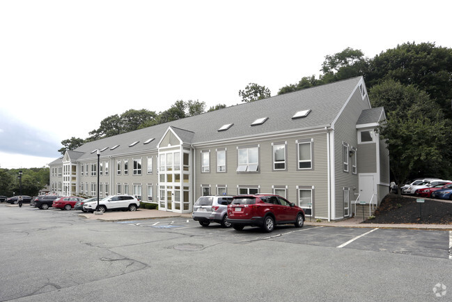
Property Record
491 Maple St, Danvers, MA 01923
Property Detail
491 Maple St
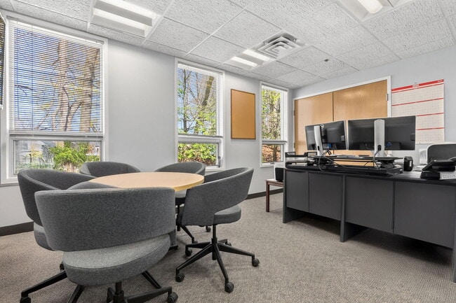
Officecondo
Essex
X
Massachusetts
25009C0403G
39
2025
Danvers/Beverly
2025
Boston
211401
Boston-Cambridge-Newton, MA-NH
919 SF
DANV-000018-000000-000039-000307-000307
NEARBY LISTINGS FOR SALE OR LEASE
DEMOGRAPHICS near 491 Maple St
1 mile
3 mile
5 mile
2024 Total Population
5,050
41,991
117,156
2029 Population
5,038
41,899
116,629
Pop Growth 2024-2029
(0.24%)
(0.22%)
(0.45%)
Average Age
44
45
44
2024 Total Households
1,838
16,881
45,860
HH Growth 2024-2029
(0.33%)
(0.21%)
(0.56%)
Median Household Inc
$105,582
$104,824
$103,132
Avg Household Size
2.30
2.40
2.50
2024 Avg HH Vehicles
2.00
2.00
2.00
Median Home Value
$612,890
$589,784
$604,616
Median Year Built
1992
1975
1967
Nearby Places
Map Layers
Map Styles
 Street
 Aerial
Transit
 Traffic
 Biking
Places
Listings with unknown addresses are not visible on the map
- Restaurants
- Banks
- Shops
- Fitness
- Groceries
PUBLIC TRANSPORTATION
COMMUTER RAIL
North Beverly (Newburyport/Rockport Line - Massachusetts Bay Transportation Authority Commuter Rail (Purple Line))
Drive
Walk
Distance
North Beverly (Newburyport/Rockport Line - Massachusetts Bay Transportation Authority Commuter Rail (Purple Line))
11 min
5.6 mi
Hamilton/Wenham (Newburyport/Rockport Line - Massachusetts Bay Transportation Authority Commuter Rail (Purple Line))
Drive
Walk
Distance
Hamilton/Wenham (Newburyport/Rockport Line - Massachusetts Bay Transportation Authority Commuter Rail (Purple Line))
15 min
7.6 mi
AIRPORT
General Edward Lawrence Logan International
Drive
Walk
Distance
General Edward Lawrence Logan International
30 min
18.4 mi
Freight Ports
Port of Boston
Drive
Walk
Distance
Port of Boston
33 min
21.3 mi
SALE & LEASE HISTORY
LISTING DATE
SALE/LEASE

Sep 24, 2016
For Lease
Nov 29, 2017
For Lease
Nov 28, 2017
For Sale
Mar 05, 2018
For Lease
Jan 08, 2020
For Lease
Dec 28, 2023
For Lease
Apr 18, 2025
For Sale
Nearby Properties
Address
Land Use
TOTAL SIZE
Lot Size
Zoning
Address
Land Use
TOTAL SIZE
Lot Size
Zoning
747,237 SF
36.70 AC
HW
Address
Land Use
TOTAL SIZE
Lot Size
Zoning
374,769 SF
71.70 AC
Address
Land Use
TOTAL SIZE
Lot Size
Zoning
252,965 SF
56.44 AC
R3
Address
Land Use
TOTAL SIZE
Lot Size
Zoning
17 AC
R4
Address
Land Use
TOTAL SIZE
Lot Size
Zoning
198.74 AC
R3
Address
Land Use
TOTAL SIZE
Lot Size
Zoning
13.04 AC
HC
Address
Land Use
TOTAL SIZE
Lot Size
Zoning
172.50 AC
R3
Address
Land Use
TOTAL SIZE
Lot Size
Zoning
49.85 AC
R1B
Address
Land Use
TOTAL SIZE
Lot Size
Zoning
101,389 SF
20 AC
I
Address
Land Use
TOTAL SIZE
Lot Size
Zoning
65.79 AC
I1
Address
Land Use
TOTAL SIZE
Lot Size
Zoning
40.20 AC
R1B
Address
Land Use
TOTAL SIZE
Lot Size
Zoning
206.65 AC
R1B
Address
Land Use
TOTAL SIZE
Lot Size
Zoning
54,302 SF
83.70 AC
R3
Address
Land Use
TOTAL SIZE
Lot Size
Zoning
408,207 SF
37.12 AC
C3
Address
Land Use
TOTAL SIZE
Lot Size
Zoning
93,789 SF
8.22 AC
HW
Address
Land Use
TOTAL SIZE
Lot Size
Zoning
111.24 AC
R3
Address
Land Use
TOTAL SIZE
Lot Size
Zoning
37,553 SF
238.29 AC
IR
Address
Land Use
TOTAL SIZE
Lot Size
Zoning
177,782 SF
12.21 AC
I2
Address
Land Use
TOTAL SIZE
Lot Size
Zoning
19.10 AC
R114
Address
Land Use
TOTAL SIZE
Lot Size
Zoning
15.32 AC
HC
Address
Land Use
TOTAL SIZE
Lot Size
Zoning
71.68 AC
R3
Address
Land Use
TOTAL SIZE
Lot Size
Zoning
15.16 AC
I2
Address
Land Use
TOTAL SIZE
Lot Size
Zoning
12.57 AC
IH
Address
Land Use
TOTAL SIZE
Lot Size
Zoning
15.88 AC
BR
Address
Land Use
TOTAL SIZE
Lot Size
Zoning
24.54 AC
M1
Address
Land Use
TOTAL SIZE
Lot Size
Zoning
139,582 SF
31.13 AC
R1
Address
Land Use
TOTAL SIZE
Lot Size
Zoning
36,156 SF
754.25 AC
R1A
Address
Land Use
TOTAL SIZE
Lot Size
Zoning
81,746 SF
10.50 AC
R1A
Address
Land Use
TOTAL SIZE
Lot Size
Zoning
4.26 AC
R114
Address
Land Use
TOTAL SIZE
Lot Size
Zoning
137,316 SF
11.51 AC
C3
The World's #1 Commercial Real Estate Marketplace
Connect with us
© 2026 CoStar Group
The information above has been obtained from sources believed reliable. While we do not doubt its accuracy we have not verified it and make no guarantee, warranty or representation about it. It is your responsibility to independently confirm its accuracy and completeness. Any projections, opinions, assumptions, or estimates used are for example only and do not represent the current or future performance of the property. The value of this transaction to you depends on tax and other factors which should be evaluated by your tax, financial, and legal advisors. You and your advisors should conduct a careful, independent investigation of the property to determine to your satisfaction the suitability of the property for your needs.