Property Record
491 N Bluff St, Saint George, UT 84770


Save to a Folder
{{folder.Name}}
{{folder.ListingIds.length}} Properties
{{folder.ListingIds.length}} Property
Create a New Folder
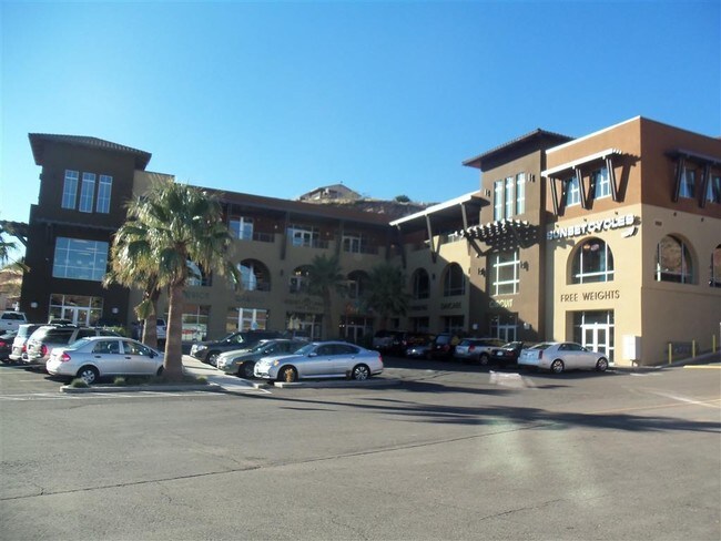
Property Detail
491 N Bluff St
0251739
S: 24 T: 42S R: 16W BEG AT PT ON WLY R/W/L OF BLUFF STREET, SD PT LOC N88*2505 W ALG EXTN OF CTR LN OF 500 NORTH STREET 340.26 FT & S18*2858 E 28.99 FT FM FND CITY SUR CTR LN CNTRL MONT AT INTSEC OF 500 NORTH ST & 600 WEST ST, SD CTR LN BEARING BEING
Commercialnec
WASHINGTON
PDCOM
Utah
B and X Area of moderate flood hazard, usually the area between the limits of the 100-year and 500-year floods.
5.65 AC
2024
Cedar City & St George
2025
Other Market Areas
271501
St. George, UT
35,034 SF
NEARBY LISTINGS FOR SALE OR LEASE
DEMOGRAPHICS near 491 N Bluff St
1 mile
3 mile
5 mile
2025 Total Population
10,893
53,402
110,241
2030 Population
11,835
58,688
120,942
Pop Growth 2025-2030
+ 8.65%
+ 9.90%
+ 9.71%
Average Age
37
40
41
2025 Total Households
3,824
19,325
38,977
HH Growth 2025-2030
+ 8.94%
+ 10.27%
+ 10.11%
Median Household Inc
$64,386
$69,217
$75,845
Avg Household Size
2.70
2.60
2.70
2025 Avg HH Vehicles
2.00
2.00
2.00
Median Home Value
$411,677
$457,474
$510,961
Median Year Built
1990
1996
2000
Nearby Places
Map Layers
Map Styles
 Street
 Aerial
Layers
 Traffic
 Biking
Places
Listings with unknown addresses are not visible on the map
- Restaurants
- Banks
- Shops
- Fitness
- Groceries
PUBLIC TRANSPORTATION
AIRPORT
St George Regional
Drive
Walk
Distance
St George Regional
6 min
1.9 mi
SALE & LEASE HISTORY
LISTING DATE
SALE/LEASE

Sep 25, 2016
For Lease
Jan 31, 2025
For Lease
Jan 28, 2020
For Lease
Dec 02, 2021
For Lease
Nearby Properties
Address
Land Use
TOTAL SIZE
Lot Size
Zoning
Address
Land Use
TOTAL SIZE
Lot Size
Zoning
1,120,988 SF
52.22 AC
PDCOM
Address
Land Use
TOTAL SIZE
Lot Size
Zoning
319,351 SF
31.39 AC
PD
Address
Land Use
TOTAL SIZE
Lot Size
Zoning
319,351 SF
31.39 AC
Address
Land Use
TOTAL SIZE
Lot Size
Zoning
163,605 SF
13.51 AC
C3
Address
Land Use
TOTAL SIZE
Lot Size
Zoning
252,737 SF
3.95 AC
C-4
Address
Land Use
TOTAL SIZE
Lot Size
Zoning
175,817 SF
30.20 AC
Address
Land Use
TOTAL SIZE
Lot Size
Zoning
118,603 SF
16.56 AC
Address
Land Use
TOTAL SIZE
Lot Size
Zoning
141,151 SF
15 AC
PDCOM
Address
Land Use
TOTAL SIZE
Lot Size
Zoning
206,801 SF
12.60 AC
PD
Address
Land Use
TOTAL SIZE
Lot Size
Zoning
9,037 SF
188.69 AC
C2
Address
Land Use
TOTAL SIZE
Lot Size
Zoning
141,567 SF
1.31 AC
C-4
Address
Land Use
TOTAL SIZE
Lot Size
Zoning
280,428 SF
1.96 AC
C-4
Address
Land Use
TOTAL SIZE
Lot Size
Zoning
91,517 SF
8.96 AC
C2
Address
Land Use
TOTAL SIZE
Lot Size
Zoning
68,899 SF
7.36 AC
C3
Address
Land Use
TOTAL SIZE
Lot Size
Zoning
84,384 SF
6.34 AC
C2
Address
Land Use
TOTAL SIZE
Lot Size
Zoning
88,445 SF
3.28 AC
C2
Address
Land Use
TOTAL SIZE
Lot Size
Zoning
97,202 SF
2.92 AC
C3
Address
Land Use
TOTAL SIZE
Lot Size
Zoning
76,907 SF
4 AC
PDCOM
Address
Land Use
TOTAL SIZE
Lot Size
Zoning
94,810 SF
3.15 AC
C-3
Address
Land Use
TOTAL SIZE
Lot Size
Zoning
59,500 SF
4.93 AC
R110
Address
Land Use
TOTAL SIZE
Lot Size
Zoning
57,312 SF
3.14 AC
PDCOM
Address
Land Use
TOTAL SIZE
Lot Size
Zoning
115,588 SF
7.61 AC
R3
Address
Land Use
TOTAL SIZE
Lot Size
Zoning
6,642 SF
67.70 AC
R110
Address
Land Use
TOTAL SIZE
Lot Size
Zoning
67,139 SF
1.25 AC
Address
Land Use
TOTAL SIZE
Lot Size
Zoning
158,638 SF
4.67 AC
C-3
Address
Land Use
TOTAL SIZE
Lot Size
Zoning
69,421 SF
5.73 AC
PDCOM
Address
Land Use
TOTAL SIZE
Lot Size
Zoning
82,440 SF
2.88 AC
Address
Land Use
TOTAL SIZE
Lot Size
Zoning
125,208 SF
4.15 AC
PDCOM
Address
Land Use
TOTAL SIZE
Lot Size
Zoning
67,892 SF
4.99 AC
Address
Land Use
TOTAL SIZE
Lot Size
Zoning
54,787 SF
4.30 AC
R110
The World's #1 Commercial Real Estate Marketplace
Connect with us
© 2026 CoStar Group
The information above has been obtained from sources believed reliable. While we do not doubt its accuracy we have not verified it and make no guarantee, warranty or representation about it. It is your responsibility to independently confirm its accuracy and completeness. Any projections, opinions, assumptions, or estimates used are for example only and do not represent the current or future performance of the property. The value of this transaction to you depends on tax and other factors which should be evaluated by your tax, financial, and legal advisors. You and your advisors should conduct a careful, independent investigation of the property to determine to your satisfaction the suitability of the property for your needs.