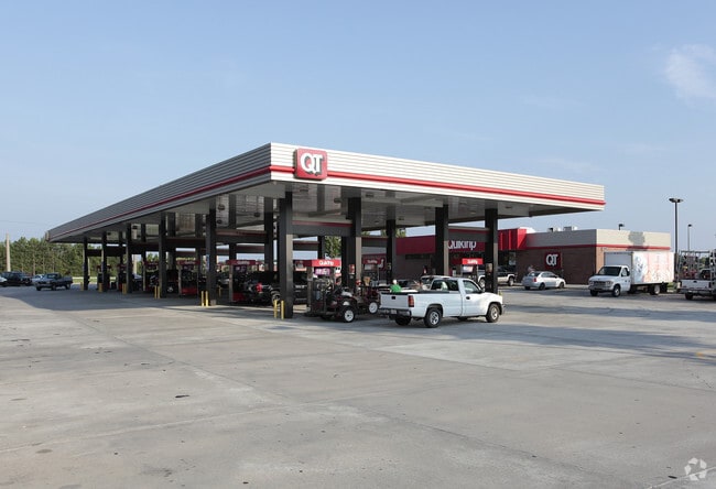
Property Record
491 Nathan Dean Blvd, Dallas, GA 30132
NEARBY LISTINGS FOR SALE OR LEASE
Property Detail
491 Nathan Dean Blvd
Atlanta-Sandy Springs-Roswell, GA
Dallas Commercial
138.3.4.019.0000
REAL PROPERTY
Storebuilding
Paulding
X
Georgia
13223C0137C
415
2025
2.11 AC
2025
Paulding Cnty/Dallas
120305
Atlanta
4,560 SF
DEMOGRAPHICS near 491 Nathan Dean Blvd
1 Mile
3 Mile
5 Mile
2024 Total Population
5,962
29,060
72,564
2029 Population
6,785
33,263
83,280
Pop Growth 2024-2029
+ 13.80%
+ 14.46%
+ 14.77%
Average Age
37
37
38
2024 Total Households
2,247
10,644
25,320
HH Growth 2024-2029
+ 13.84%
+ 14.52%
+ 14.82%
Median Household Inc
$67,965
$71,770
$85,427
Avg Household Size
2.70
2.70
2.80
2024 Avg HH Vehicles
2.00
2.00
2.00
Median Home Value
$225,913
$195,946
$220,759
Median Year Built
2001
1998
1999
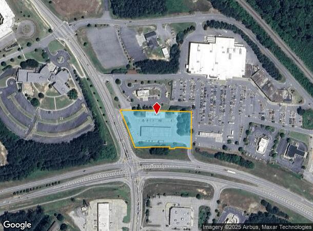
Nearby Places
Map Layers
Map Styles
 Street
 Aerial
- Restaurants
- Banks
- Shops
- Fitness
- Groceries
PUBLIC TRANSPORTATION
AIRPORT
Hartsfield - Jackson Atlanta International
DRIVE
WALK
Distance
Hartsfield - Jackson Atlanta International
58 min
39.0 mi
Freight Ports
Georgia Ports - Savannah
DRIVE
WALK
Distance
Georgia Ports - Savannah
321 min
278.3 mi
Nearby Properties
Address
Land Use
TOTAL SIZE
Lot Size
Zoning
Address
Land Use
TOTAL SIZE
Lot Size
Zoning
83.40 AC
OMI
Address
Land Use
TOTAL SIZE
Lot Size
Zoning
62,628 SF
32.23 AC
B2
Address
Land Use
TOTAL SIZE
Lot Size
Zoning
62.35 AC
Address
Land Use
TOTAL SIZE
Lot Size
Zoning
126,638 SF
20.26 AC
R4
Address
Land Use
TOTAL SIZE
Lot Size
Zoning
133,468 SF
12.37 AC
MF1
Address
Land Use
TOTAL SIZE
Lot Size
Zoning
187,435 SF
31.39 AC
R55
Address
Land Use
TOTAL SIZE
Lot Size
Zoning
Address
Land Use
TOTAL SIZE
Lot Size
Zoning
25.11 AC
Address
Land Use
TOTAL SIZE
Lot Size
Zoning
179,316 SF
13.43 AC
MF1
Address
Land Use
TOTAL SIZE
Lot Size
Zoning
20.91 AC
Address
Land Use
TOTAL SIZE
Lot Size
Zoning
19,718 SF
0.52 AC
B1
Address
Land Use
TOTAL SIZE
Lot Size
Zoning
35,442 SF
0.66 AC
B1
Address
Land Use
TOTAL SIZE
Lot Size
Zoning
0.44 AC
CBD
Address
Land Use
TOTAL SIZE
Lot Size
Zoning
149,128 SF
108.92 AC
I1
Address
Land Use
TOTAL SIZE
Lot Size
Zoning
71,122 SF
30.70 AC
OMI
Address
Land Use
TOTAL SIZE
Lot Size
Zoning
145,409 SF
12.09 AC
I1
Address
Land Use
TOTAL SIZE
Lot Size
Zoning
39,290 SF
10.56 AC
R4
Address
Land Use
TOTAL SIZE
Lot Size
Zoning
136,556 SF
7.24 AC
B2
Address
Land Use
TOTAL SIZE
Lot Size
Zoning
7.69 AC
Address
Land Use
TOTAL SIZE
Lot Size
Zoning
26,770 SF
3.62 AC
R1
Address
Land Use
TOTAL SIZE
Lot Size
Zoning
42,774 SF
7.61 AC
OMI
Address
Land Use
TOTAL SIZE
Lot Size
Zoning
0.56 AC
Address
Land Use
TOTAL SIZE
Lot Size
Zoning
8.59 AC
Address
Land Use
TOTAL SIZE
Lot Size
Zoning
71,416 SF
8.58 AC
B2
Address
Land Use
TOTAL SIZE
Lot Size
Zoning
128.92 AC
Address
Land Use
TOTAL SIZE
Lot Size
Zoning
62,175 SF
4.39 AC
I1
Address
Land Use
TOTAL SIZE
Lot Size
Zoning
45,560 SF
4.06 AC
OMI
Address
Land Use
TOTAL SIZE
Lot Size
Zoning
112,906 SF
11.19 AC
I1
Address
Land Use
TOTAL SIZE
Lot Size
Zoning
57,800 SF
10.48 AC
MF1
Address
Land Use
TOTAL SIZE
Lot Size
Zoning
33,024 SF
5.41 AC
TH
The World's #1 Commercial Real Estate Marketplace
Connect with us
© 2026 CoStar Group
The information above has been obtained from sources believed reliable. While we do not doubt its accuracy we have not verified it and make no guarantee, warranty or representation about it. It is your responsibility to independently confirm its accuracy and completeness. Any projections, opinions, assumptions, or estimates used are for example only and do not represent the current or future performance of the property. The value of this transaction to you depends on tax and other factors which should be evaluated by your tax, financial, and legal advisors. You and your advisors should conduct a careful, independent investigation of the property to determine to your satisfaction the suitability of the property for your needs.