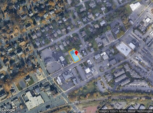
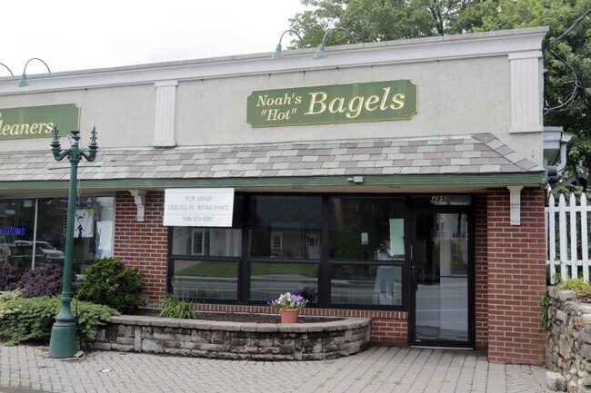
Property Record
491 Springfield Ave, Berkeley Heights, NJ 07922

NEARBY LISTINGS FOR SALE OR LEASE
Property Detail
491 Springfield Ave
01-00206-0000-00013
Union
Commercialnec
New Jersey
X
13
34035C0087E
0.26 AC
2024
Route 78 East
2025
Northern New Jersey
038202
Newark, NJ
7,088 SF
DEMOGRAPHICS near 491 Springfield Ave
1 Mile
3 Mile
5 Mile
2024 Total Population
7,266
39,797
171,839
2029 Population
7,309
39,795
170,803
Pop Growth 2024-2029
+ 0.59%
(0.01%)
(0.60%)
Average Age
42
42
40
2024 Total Households
2,504
13,918
58,003
HH Growth 2024-2029
+ 0.48%
(0.22%)
(0.71%)
Median Household Inc
$151,278
$162,088
$133,882
Avg Household Size
2.80
2.80
2.90
2024 Avg HH Vehicles
2.00
2.00
2.00
Median Home Value
$716,049
$730,647
$695,515
Median Year Built
1967
1965
1958
Nearby Places
Map Layers
Map Styles
 Street
 Aerial
- Restaurants
- Banks
- Shops
- Fitness
- Groceries
PUBLIC TRANSPORTATION
COMMUTER RAIL
Berkeley Heights (Morris & Essex Gladstone Branch - NJ Transit Commuter Rail (NJ Transit))
DRIVE
WALK
Distance
Berkeley Heights (Morris & Essex Gladstone Branch - NJ Transit Commuter Rail (NJ Transit))
1 min
4 min
0.2 mi
Gillette (Morris & Essex Gladstone Branch - NJ Transit Commuter Rail (NJ Transit))
DRIVE
WALK
Distance
Gillette (Morris & Essex Gladstone Branch - NJ Transit Commuter Rail (NJ Transit))
4 min
1.8 mi
SALE & LEASE HISTORY
LISTING DATE
SALE/LEASE

Sep 19, 2018
For Lease
Jul 18, 2017
For Lease
Nearby Properties
Address
Land Use
TOTAL SIZE
Lot Size
Zoning
Address
Land Use
TOTAL SIZE
Lot Size
Zoning
151,088 SF
26.48 AC
CCRC
Address
Land Use
TOTAL SIZE
Lot Size
Zoning
153.40 AC
OR
Address
Land Use
TOTAL SIZE
Lot Size
Zoning
439.33 AC
Address
Land Use
TOTAL SIZE
Lot Size
Zoning
47.69 AC
MU
Address
Land Use
TOTAL SIZE
Lot Size
Zoning
47.80 AC
H-D
Address
Land Use
TOTAL SIZE
Lot Size
Zoning
34.60 AC
MU
Address
Land Use
TOTAL SIZE
Lot Size
Zoning
67.22 AC
R65
Address
Land Use
TOTAL SIZE
Lot Size
Zoning
140,732 SF
42.73 AC
OR
Address
Land Use
TOTAL SIZE
Lot Size
Zoning
23.93 AC
B2
Address
Land Use
TOTAL SIZE
Lot Size
Zoning
24.92 AC
MU
Address
Land Use
TOTAL SIZE
Lot Size
Zoning
61,912 SF
16 AC
OR
Address
Land Use
TOTAL SIZE
Lot Size
Zoning
23.66 AC
R2
Address
Land Use
TOTAL SIZE
Lot Size
Zoning
356.94 AC
OL
Address
Land Use
TOTAL SIZE
Lot Size
Zoning
8.09 AC
B3
Address
Land Use
TOTAL SIZE
Lot Size
Zoning
36.55 AC
OL
Address
Land Use
TOTAL SIZE
Lot Size
Zoning
184,000 SF
24.43 AC
OR
Address
Land Use
TOTAL SIZE
Lot Size
Zoning
6.76 AC
MU
Address
Land Use
TOTAL SIZE
Lot Size
Zoning
3,612 SF
7.92 AC
C
Address
Land Use
TOTAL SIZE
Lot Size
Zoning
16.30 AC
OR
Address
Land Use
TOTAL SIZE
Lot Size
Zoning
34.89 AC
R-1
Address
Land Use
TOTAL SIZE
Lot Size
Zoning
218,207 SF
15.28 AC
Address
Land Use
TOTAL SIZE
Lot Size
Zoning
35.20 AC
OL
Address
Land Use
TOTAL SIZE
Lot Size
Zoning
9.53 AC
DD
Address
Land Use
TOTAL SIZE
Lot Size
Zoning
24.62 AC
CCRC
Address
Land Use
TOTAL SIZE
Lot Size
Zoning
16.32 AC
R2
Address
Land Use
TOTAL SIZE
Lot Size
Zoning
Address
Land Use
TOTAL SIZE
Lot Size
Zoning
11.16 AC
R-3
Address
Land Use
TOTAL SIZE
Lot Size
Zoning
8.56 AC
R2
Address
Land Use
TOTAL SIZE
Lot Size
Zoning
27.24 AC
A-H
Address
Land Use
TOTAL SIZE
Lot Size
Zoning
88 SF
5.27 AC
R4
The World's #1 Commercial Real Estate Marketplace
Connect with us
© 2026 CoStar Group
The information above has been obtained from sources believed reliable. While we do not doubt its accuracy we have not verified it and make no guarantee, warranty or representation about it. It is your responsibility to independently confirm its accuracy and completeness. Any projections, opinions, assumptions, or estimates used are for example only and do not represent the current or future performance of the property. The value of this transaction to you depends on tax and other factors which should be evaluated by your tax, financial, and legal advisors. You and your advisors should conduct a careful, independent investigation of the property to determine to your satisfaction the suitability of the property for your needs.